Zir'in
Zir'in
زرعين Zer'en | |
|---|---|
Desa | |
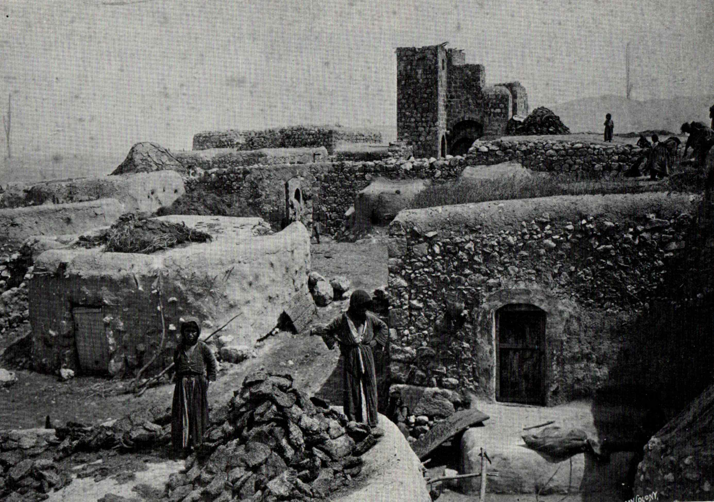
 Rumah Menara Zir'in, oleh Felix Bonfils, sebelum 1885. | |
 Zir'in | |
| Koordinat: 32°33′27″N 35°19′40″E / 32.55750°N 35.32778°E | |
| Grid Palestina | 181/218 |
| Entitas geopolitik | Mandat Palestina |
| Subdistrik | Jenin |
| Tanggal pengosongan | 28 Mei 1948[1] |
| Luas | |
| • Total | 23,920 dunams (2,3.920 ha or 5,911 acre) |
| Populasi (1945) | |
| • Total | 1.420 |
| Sebab pengosongan | Serangan militer oleh pasukan Yishuv |
| Wilayah saat ini | Yizre'el |
Zir'in (bahasa Arab: زرعين, juga disebut Zerein) adalah sebuah desa Arab Palestina di Lembah Jezreel, yang berjarak 11 kilometer (6,8 mi) dari utara Jenin. Diidentifikasikan sebagai kota kuno Yizre'el (Jezreel), desa terebut dikenal sebagai Zir'in pada masa kekuasaan Islam, dan berada di dekat situs Pertempuran Ain Jalut, di mana Mamluk menghadapi ekspansi Mongol dari wilayah selatan. Di bawah kekuasaan Utsmaniyah, desa tersebut menjadi sebuah desa kecil, diperlebar pada masa Mandat Britania pada awal abad ke-20. Setelah direbut oleh Israel pada 1948, Zir'in dihancurkan.
Referensi
Daftar pustaka
- Barron, J.B., ed. (1923). Palestine: Report and General Abstracts of the Census of 1922. Government of Palestine.
- Conder, C.R.; Kitchener, H.H. (1882). The Survey of Western Palestine: Memoirs of the Topography, Orography, Hydrography, and Archaeology. Vol. 2. London: Committee of the Palestine Exploration Fund.
- Government of Palestine, Department of Statistics (1945). Village Statistics, April, 1945.
- Guérin, V. (1874). Description Géographique Historique et Archéologique de la Palestine (dalam bahasa French). Vol. 2: Samarie, pt. 1. Paris: L'Imprimerie Nationale. Pemeliharaan CS1: Bahasa yang tidak diketahui (link) (pp.311 - 323)
- Hadawi, S. (1970). Village Statistics of 1945: A Classification of Land and Area ownership in Palestine. Palestine Liberation Organization Research Center.
- Hütteroth, Wolf-Dieter; Abdulfattah, Kamal (1977). Historical Geography of Palestine, Transjordan and Southern Syria in the Late 16th Century. Erlanger Geographische Arbeiten, Sonderband 5. Erlangen, Germany: Vorstand der Fränkischen Geographischen Gesellschaft. ISBN 3-920405-41-2.
- Karmon, Y. (1960). "An Analysis of Jacotin's Map of Palestine" (PDF). Israel Exploration Journal. 10 (3, 4): 155–173, 244–253. Diarsipkan dari asli (PDF) tanggal 2019-12-22. Diakses tanggal 2020-07-23.
- Khalidi, W. (1992). All That Remains: The Palestinian Villages Occupied and Depopulated by Israel in 1948. Washington D.C.: Institute for Palestine Studies. ISBN 0-88728-224-5.
- Lyons, Malcolm Cameron; Jackson, D.E.P. (1984). Saladin: the Politics of the Holy War. Cambridge University Press. ISBN 978-0-521-31739-9.
- Mills, E., ed. (1932). Census of Palestine 1931. Population of Villages, Towns and Administrative Areas. Jerusalem: Government of Palestine.
- Morris, B. (2004). The Birth of the Palestinian Refugee Problem Revisited. Cambridge University Press. ISBN 978-0-521-00967-6.
- Palmer, E.H. (1881). The Survey of Western Palestine: Arabic and English Name Lists Collected During the Survey by Lieutenants Conder and Kitchener, R. E. Transliterated and Explained by E.H. Palmer. Committee of the Palestine Exploration Fund. (p.172)
- Petersen, Andrew (2001). A Gazetteer of Buildings in Muslim Palestine (British Academy Monographs in Archaeology). Vol. I. Oxford University Press. ISBN 978-0-19-727011-0.
- Pringle, Denys (1993). The Churches of the Crusader Kingdom of Jerusalem: A-K (excluding Acre and Jerusalem). Vol. I. Cambridge University Press. ISBN 0 521 39036 2. (pp. 276-278)
- Pringle, Denys (1997). Secular buildings in the Crusader Kingdom of Jerusalem: an archaeological Gazetter. Cambridge University Press. ISBN 0521 46010 7.
- Pringle, Denys (2009). The Churches of the Crusader Kingdom of Jerusalem: The cities of Acre and Tyre with Addenda and Corrigenda to Volumes I-III. Vol. IV. Cambridge University Press. ISBN 978-0-521-85148-0. ( pp. 269-272)
- Robinson, E.; Smith, E. (1841). Biblical Researches in Palestine, Mount Sinai and Arabia Petraea: A Journal of Travels in the year 1838. Vol. 3. Boston: Crocker & Brewster.
- Tal, D. (2004). War in Palestine, 1948: Strategy and Diplomacy. Routledge. ISBN 0-7146-5275-X.
- Wilson, C.W., ed. (c. 1881). Picturesque Palestine, Sinai and Egypt. Vol. 2. New York: D. Appleton.
Pranala luar
- Welcome to Zir'in
- Zir'in, Zochrot
- Survey of Western Palestine, Map 9: IAA, Wikimedia commons
- Zir'in at Khalil Sakakini Cultural Center
- Zir'in Diarsipkan 2003-11-20 di Wayback Machine. by Rami Nashashibi (1996), Center for Research and Documentation of Palestinian Society.
- Zir'in, circa 1900
| Internasional | |
|---|---|
| Nasional | |
Content Disclaimer
Informasi ini disarikan dari Wikipedia dan disajikan kembali untuk tujuan edukasi. Konten tersedia di bawah lisensi CC BY-SA 3.0. Kami tidak bertanggung jawab atas ketidakakuratan data yang bersumber dari kontribusi publik tersebut.
- The information displayed on this website is sourced in part or in whole from Wikipedia and has been adapted for the purpose of restating it. We strive to provide accurate and relevant information, however:
- There is no guarantee of absolute accuracy. Wikipedia is an open, collaborative project that can be edited by anyone, so information is subject to change.
- It is not intended to constitute professional advice. The content displayed is for informational and educational purposes only. For important decisions (e.g., medical, legal, or financial), please consult a professional.
- Content copyright. Wikipedia is licensed under the Creative Commons Attribution-ShareAlike License (CC BY-SA). This means that content may be reused with appropriate attribution and shared under a similar license.
- Responsible use. Any risk arising from the use of information from this website is entirely the responsibility of the user.