Diyala
| Provinsen Diyala محافظة ديالى | |
|---|---|
 Dæmning på Diyala floden | |
| Overblik | |
| Land: | |
| Guvernør | Muthana Al-Timimi |
| Administrativt center: | Baquba |
| Demografi | |
| Indbyggere: | 1.371.035 (2009) |
| - Areal: | 14.700 km² |
| - Befolkningstæthed: | 93,3 pr. km² |
| Sprog: | arabisk kurdisk |
| Andet | |
| Tidszone: | UTC+3 |
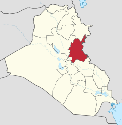
| Oversigtskort | |
 | |
 | |
Diyala (arabisk: محافظة ديالى) er en irakisk provins, beliggende mellem Bagdad og den iranske grænse. Provinsen dækker et areal på 17.685 km² og har 1.371.035(2009) indbyggere.
Provinsens hovedby er Baquba med 467.900(2003) indbyggere.
Provinsen Diyala er opdelt i seks distrikter:
Referencer
Eksterne henvisninger
| Spire Denne artikel om irakisk geografi er en spire som bør udbygges. Du er velkommen til at hjælpe Wikipedia ved at udvide den. |
Content Disclaimer
Informasi ini disarikan dari Wikipedia dan disajikan kembali untuk tujuan edukasi. Konten tersedia di bawah lisensi CC BY-SA 3.0. Kami tidak bertanggung jawab atas ketidakakuratan data yang bersumber dari kontribusi publik tersebut.
- The information displayed on this website is sourced in part or in whole from Wikipedia and has been adapted for the purpose of restating it. We strive to provide accurate and relevant information, however:
- There is no guarantee of absolute accuracy. Wikipedia is an open, collaborative project that can be edited by anyone, so information is subject to change.
- It is not intended to constitute professional advice. The content displayed is for informational and educational purposes only. For important decisions (e.g., medical, legal, or financial), please consult a professional.
- Content copyright. Wikipedia is licensed under the Creative Commons Attribution-ShareAlike License (CC BY-SA). This means that content may be reused with appropriate attribution and shared under a similar license.
- Responsible use. Any risk arising from the use of information from this website is entirely the responsibility of the user.