Share to: share facebook share twitter share wa share telegram print page


2000 Tottori earthquake

2000 Tottori earthquake
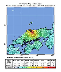
USGS ShakeMap
2000 Tottori earthquake is located in Tottori Prefecture
2000 Tottori earthquake
2000 Tottori earthquake is located in Japan
2000 Tottori earthquake
UTC time2000-10-06 04:30:20
ISC event1839998
USGS-ANSSComCat
Local date6 October 2000 (2000-10-06)
Local time13:30:20 JST (UTC+9)
Magnitude7.3 MJMA
6.7 Mw
Depth10 km (6 mi) (USGS)
9 km (6 mi) (JMA)[1]
Epicenter35°16′N 133°19′E / 35.27°N 133.31°E / 35.27; 133.31[1]
TypeStrike-slip
Areas affectedChūgoku, Shikoku and Kansai regions, Japan
Total damage¥23.63 billion (US$150 million)
Max. intensityJMA 6+ (MMI X)
Landslides≥367
Casualties182 injuries

The 2000 Tottori earthquake (Japanese: 鳥取県西部地震) occurred on 6 October 2000, at 13:30:20 local time with a moment magnitude of 6.7 and a maximum Mercalli intensity of X (Extreme). The epicenter was located in Nambu, near the border with Yasugi, Shimane. About $150 million in damage was caused, with 109,095 homes damaged or destroyed, and at least 182 people were injured.

Earthquake

The United States Geological Survey (USGS) reported a moment magnitude of 6.7 and a focal depth of 10 km (6.2 mi) for the earthquake.[2] The Japan Meteorological Agency recorded a magnitude of MJMA  7.3.[3] This was the first time since the seismic intensity classification was revised in 1996 that a JMA maximum seismic intensity of 6+ or higher was recorded.[4] A USGS seismic installation at Hino recorded 0.9402 g in ground acceleration (pga) and 260.83 cm/s (102.69 in/s) in ground velocity; the station data corresponded to a Modified Mercalli intensity of X (Extreme).[5]

The earthquake was an almost pure left-lateral strike-slip event. It was not caused by the activity of a known fault, but by the activity of an unidentified underground fault. Multiple ground cracks appeared due to underground displacement. The aftershock area was distributed along the source fault of the main shock, from Yasugi City in Shimane Prefecture to Hino District in Tottori Prefecture, extending from south-southeast to north-northwest in a length of approximately 30 km and a depth of approximately 15 km. Prior to the earthquake, swarms of magnitude 5 earthquake activity occurred along the deep extension of the fault in 1989, 1990, and 1997.[6] The earthquake also caused 367 landslides; 348 in Tottori, 18 in Okayama and one in Tokushima.[7]

Locations with a seismic intensity of Shindo 5− and higher[3]
Intensity Prefecture Locations
6+ Tottori Hino, Sakaiminato
6− Tottori Yonago, Hiezu, Hōki, Nambu
5+ Shimane Matsue, Yasugi, Okuizumo
Okayama Niimi, Maniwa
Kagawa Tonoshō
5− Tottori Daisen, Kotoura, Hokuei, Yurihama, Kurayoshi
Shimane Izumo, Unnan, Ōda, Gōtsu
Okayama Okayama, Takahashi, Kibichūō, Tamano, Kurashiki, Kasaoka
Kagawa Takamatsu, Shōdoshima, Mitoyo, Kanonji, Higashikagawa
Hiroshima Fukuyama, Shōbara, Ōsakikamijima, Kure, Fuchū
Tokushima Tokushima
Hyōgo Awaji

Impact

At least 182 people were injured, 39 of them seriously, due to the earthquake, including 141 in Tottori, 18 in Okayama, 11 in Shimane, four in Osaka, three in Hiroshima, two in Kagawa, and one each in Hyōgo, Wakayama and Yamaguchi. The earthquake completely destroyed 2,158 homes, severely damaged 16,220 and partially damaged 90,717 others, with all structural collapses occurring in Tottori, Okayama and Shimane. Additionally, 6,801 waterways, 700 cultural and educational facilities, 667 roads, 254 public buildings, 91 harbors, 78 rivers, 47 hospitals, 20 bridges, five ships and 2,943 other structures were also affected.[7] Liquefaction was reported in Sakaiminato City and homes were destroyed in Hino, Yonago, and other areas. Damage estimates exceeded ¥23.63 billion (US$150 million).[6]

See also

References

  1. ^ a b ISC (2015), ISC-GEM Global Instrumental Earthquake Catalogue (1900–2009), Version 2.0, International Seismological Centre
  2. ^ "M 6.7 – 8 km ESE of Matsue, Japan". United States Geological Survey.
  3. ^ a b "Seismic Intensity Database Search". Japan Meteorological Agency. 6 October 2000. Retrieved 13 January 2025.
  4. ^ "震度データベース検索". Japan Meteorological Agency. Retrieved 16 May 2024.
  5. ^ ANSS. "M 6.7 - 8 km ESE of Matsue, Japan - ShakeMap 2000". Comprehensive Catalog. U.S. Geological Survey.
  6. ^ a b Semmane, Fethi; Cotton, Fabrice; Campillo, Michel (2005). "The 2000 Tottori earthquake: A shallow earthquake with no surface rupture and slip properties controlled by depth". Journal of Geophysical Research: Solid Earth. 110 (B3). Bibcode:2005JGRB..110.3306S. doi:10.1029/2004JB003194.
  7. ^ a b 平成12年(2000年)鳥取県西部地震 (PDF) (Report) (in Japanese). Fire and Disaster Management Agency. 10 October 2002. Retrieved 13 January 2025.

Further reading

  • Ohmi, S.; Watanabe, K.; Shibutani, T.; Hirano, N.; Nakao, S. (2002), "The 2000 Western Tottori Earthquake—Seismic activity revealed by the regional seismic networks—", Earth, Planets and Space, 54 (8): 819–830, Bibcode:2002EP&S...54..819O, doi:10.1186/BF03352075
  • Umeda, K.; Asamori, K.; Negi, T.; Kusano, T. (2011), "A large intraplate earthquake triggered by latent magmatism", Journal of Geophysical Research, 116 (B1): B01207, Bibcode:2011JGRB..116.1207U, doi:10.1029/2010JB007963
Prefix: a b c d e f g h i j k l m n o p q r s t u v w x y z 0 1 2 3 4 5 6 7 8 9

Portal di Ensiklopedia Dunia

Kembali kehalaman sebelumnya