Share to: share facebook share twitter share wa share telegram print page

Blacklick Township, Cambria County, Pennsylvania

Blacklick Township, Pennsylvania
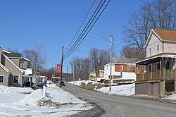
Pennsylvania Route 271 in the community of Twin Rocks
Map of Cambria County, Pennsylvania highlighting Blacklick Township
Map of Cambria County, Pennsylvania
CountryUnited States
StatePennsylvania
CountyCambria
IncorporatedOctober 10, 1850
Area
 • Total
31.20 sq mi (80.80 km2)
 • Land31.15 sq mi (80.68 km2)
 • Water0.05 sq mi (0.12 km2)
Population
 • Total
1,880 Decrease
 • Estimate 
(2021)[2]
1,866
 • Density61.38/sq mi (23.70/km2)
Time zoneUTC-5 (Eastern (EST))
 • Summer (DST)UTC-4 (EDT)
Area code814
FIPS code42-021-06736

Blacklick Township is a township in Cambria County, Pennsylvania, United States. The population was 1,880 at the 2020 census.[2] It is part of the Johnstown, Pennsylvania Metropolitan Statistical Area.

Geography

Blacklick Township is located in western Cambria County at 40.613171,-78.787422.[3] It is bordered to the west by Indiana County. The South Branch of Blacklick Creek forms the majority of the southern border of the township, and the North Branch of Blacklick Creek flows through the western part of the township. The boroughs of Nanty-Glo and Vintondale border the township on the south. Ebensburg, the Cambria County seat, is 7 miles (11 km) to the east, and the city of Johnstown is 12 miles (19 km) to the south.

According to the United States Census Bureau, Blacklick Township has a total area of 31.2 square miles (80.8 km2), of which 31.2 square miles (80.7 km2) is land and 0.04 square miles (0.1 km2), or 0.15%, is water.[4]

Communities

Unincorporated communities

Demographics

Historical population
CensusPop.Note
20002,200
20102,013−8.5%
20201,880−6.6%
2021 (est.)1,866[2]−0.7%
U.S. Decennial Census[5]

At the 2000 census there were 2,200 people, 833 households, and 638 families in the township. The population density was 70.7 inhabitants per square mile (27.3/km2). There were 897 housing units at an average density of 28.8 per square mile (11.1/km2). The racial makeup of the township was 99.59% White, 69% African American, 0.05% Asian, 0.05% from other races, and 0.27% from two or more races. Hispanic or Latino of any race were 0.09%.[6]

There were 833 households, 29.4% had children under the age of 18 living with them, 63.1% were married couples living together, 9.2% had a female householder with no husband present, and 23.4% were non-families. 19.7% of households were made up of individuals, and 11.0% were one person aged 65 or older. The average household size was 2.63 and the average family size was 3.03.

The age distribution was 21.5% under the age of 18, 8.7% from 18 to 24, 28.1% from 25 to 44, 26.1% from 45 to 64, and 15.6% 65 or older. The median age was 41 years. For every 100 females there were 103.7 males. For every 100 females age 18 and over, there were 99.8 males.

The median household income was $31,504 and the median family income was $34,777. Males had a median income of $27,885 versus $21,250 for females. The per capita income for the township was $14,244. 9.8% of the population and 10.0% of families were below the poverty line. 11.9% of those under the age of 18 and 8.1% of those 65 and older were living below the poverty line.

References

  1. ^ "2016 U.S. Gazetteer Files". United States Census Bureau. Retrieved August 13, 2017.
  2. ^ a b c d "City and Town Population Totals: 2020—2021". Census.gov. US Census Bureau. Retrieved August 19, 2022.
  3. ^ "US Gazetteer files: 2010, 2000, and 1990". United States Census Bureau. February 12, 2011. Retrieved April 23, 2011.
  4. ^ "Geographic Identifiers: 2010 Demographic Profile Data (G001): Blacklick township, Cambria County, Pennsylvania". U.S. Census Bureau, American Factfinder. Archived from the original on February 13, 2020. Retrieved March 23, 2015.
  5. ^ "Census of Population and Housing". Census.gov. Retrieved June 4, 2016.
  6. ^ "U.S. Census website". United States Census Bureau. Retrieved January 31, 2008.

40°31′05″N 78°52′17″W / 40.51806°N 78.87139°W / 40.51806; -78.87139

Read other articles:

Elise TestoneLahir29 Juli 1983 (umur 40)Kinnelon, New Jersey, Amerika SerikatGenreBlues,[1] rock,[1] soul[1]PekerjaanPenyanyiInstrumenVokal, piano, gitar, drumTahun aktif2005-sekarang Elise Testone (lahir 29 Juli 1983) adalah penyanyi yang berasal dari Mount Pleasant, South Carolina. Ia merupakan salah satu finalis American Idol musim kesebelas. Kehidupan awal Testone lahir pada tanggal 29 Juli 1983, dari pasangan LuAnne dan Victor Testone.[2][3] Refe…

Artikel ini perlu diwikifikasi agar memenuhi standar kualitas Wikipedia. Anda dapat memberikan bantuan berupa penambahan pranala dalam, atau dengan merapikan tata letak dari artikel ini. Untuk keterangan lebih lanjut, klik [tampil] di bagian kanan. Mengganti markah HTML dengan markah wiki bila dimungkinkan. Tambahkan pranala wiki. Bila dirasa perlu, buatlah pautan ke artikel wiki lainnya dengan cara menambahkan [[ dan ]] pada kata yang bersangkutan (lihat WP:LINK untuk keterangan lebih lanjut). …

UlujamiKecamatanPeta lokasi Kecamatan UlujamiNegara IndonesiaProvinsiJawa TengahKabupatenPemalangPopulasi • Total107,898 jiwaKode Kemendagri33.27.13 Kode BPS3327130 Luas2.305 haDesa/kelurahan18 Desa Ulujami (Jawa: ꦈꦭꦸꦗꦩꦶ, translit. Ulujami) adalah sebuah kecamatan di Kabupaten Pemalang, Jawa Tengah, Indonesia. Ulujami berbatasan langsung di sebelah timur dengan Kabupaten Pekalongan. Pemerintahan Kecamatan Ulujami berada di Desa Rowosari Peninggalan Sejarah D…

Intan dan grafit adalah dua alotrop karbon: bentuk murni dari unsur yang sama tetapi berbeda dalam struktur. Alotropi atau alotropisme (dari bahasa Yunani allos, 'lainnya', dan tropos, 'tata krama') adalah sebuah perilaku yang diperlihatkan oleh beberapa unsur kimia. Unsur-unsur seperti ini dapat ditemukan dalam dua bentuk atau bisa juga lebih, yang dikenal sebagai allotrop unsur tersebut. Pada tiap alotrop, atom-atom unsur tersebut terikat dalam bentuk yang berbeda-beda. Alotrop adalah modifika…

Nesher נֶשֶׁרTranskripsi bahasa Ibrani • ISO 259NešrDistrik HaifaDidirikan1925Pemerintahan • JenisKota • Kepala DaerahAvi BinamoLuas • Total12.090 dunams (12,09 km2 or 4,67 sq mi)Populasi (2010) • Total23.000 • Kepadatan1,9/km2 (4,9/sq mi)Arti namaEagle Nesher (Ibrani: נֶשֶׁר) adalah sebuah kota di Distrik Haifa, Israel. Pada 2011, Nesher memiliki populasi sebesa…

التصنيف الرئيسي | اقتصاد | جغرافيا | سياسة | تاريخ | رياضة | عدل   بوابة جنوب السودان علم جنوب السودان شعار جمهوية جنوب السودان جمهورية جنوب السودان هي دولة تقع في شرق أفريقيا، وتعتبر مدينة جوبا عاصمتها وأكبر مدنها، ومن أكبر مدنها هي واو وملكال ورومبيك وأويل وياي. وتجدر الإ…

Robert BridgesPekerjaanPenulisKebangsaanBritaniaAlmamaterEton, OxfordGenrePuisiPenghargaanPenyair laureat Robert Seymour Bridges, OM, (23 November 1844 – 21 April 1930) adalah penyair dan penyair laureat Britania dari tahun 1913 sampai 1930. Referensi Bridges, Robert: The Poetical Works of Robert Bridges, Oxford Editions of Standard Authors, Oxford University Press, 2nd edition, 1936. (reissued 1953 with The Testament of Beauty) Guérard, Albert, Jr.: Robert Bridges: A Study of T…

Strada statale 670dei Piani d'AspromonteDenominazioni successiveStrada provinciale 6 Inn. SS 18 (Villa San Giovanni) - Inn. ex SS 183 (Bivio per Gambarie) LocalizzazioneStato Italia Regioni Calabria Province Reggio Calabria DatiClassificazioneStrada statale InizioVilla San Giovanni Fineex SS 183 presso Gambarie Lunghezza30,200[1] km Provvedimento di istituzioneD.M. 49 del 06/02/1992 - G.U. 49 del 28/02/1992[2] GestoreANAS (1992-2002) Manuale La ex strada statale 67…

Sjønståfjell TunnelOverviewLocationFauske, Nordland, NorwayCoordinates67°11′57″N 15°40′01″E / 67.1991°N 15.6670°E / 67.1991; 15.6670Route Fv830StartStorvikaEndnear SjønståOperationOpened1956/1975TrafficAutomotiveTechnicalLength2,827 metres (9,275 ft) The Sjønståfjell Tunnel (Norwegian: Sjønståfjelltunnelen) is a road tunnel that is part of Norwegian County Road 830 in the municipality of Fauske in Nordland county, Norway. It is located between Fin…

JawaNama lokal: ꦗꦮ (Jawa)ᮏᮝ (Sunda)Topografi Pulau JawaGeografiLokasiAsia TenggaraKoordinat7°29′30″S 110°00′16″E / 7.49167°S 110.00444°E / -7.49167; 110.00444Koordinat: 7°29′30″S 110°00′16″E / 7.49167°S 110.00444°E / -7.49167; 110.00444KepulauanKepulauan Sunda BesarLuas132.114 (sudah termasuk laut) km2Peringkat luaske-13Titik tertinggiGunung Semeru (3.676 m)PemerintahanNegara IndonesiaProvins…

Cuisine of ethnic Indian communities of Malaysia This article uses bare URLs, which are uninformative and vulnerable to link rot. Please consider converting them to full citations to ensure the article remains verifiable and maintains a consistent citation style. Several templates and tools are available to assist in formatting, such as reFill (documentation) and Citation bot (documentation). (August 2022) (Learn how and when to remove this template message) Indian rojak in Malaysia. This articl…

This article is about a square in Banská Bystrica. For other squares with the same name, see SNP Square (disambiguation). The Slovak National Uprising Square Slovak National Uprising Square (Námestie Slovenského národného povstania), or SNP Square (Námestie SNP) is an area in central Banská Bystrica, Slovakia, named after the insurgency of 1944. It has been the hub of the city's life and a prestigious address for more than 600 years. During the 20th century, the square saw periodic mass g…

اَلشَّيْخ عُمَر اَلقَاضي (من اليمين إلى اليسار) : الشيخ عمر مع والده الشيخ عبد الوهاب القاضي. معلومات شخصية الاسم الكامل الشِّيخ عُمَر بن عَبد الوهاب بن عبد الرَّحيم بن عبد الله القاضِي الميلاد 1347 هـ / 1929 مدَشتي، هَرمُزَكَان، إيران الوفاة 6 ذو الحجة 1425 هـ / 28 يناير 2004 م (75 عام…

Pour les articles homonymes, voir Porcelaine (homonymie). La porcelaine est caractérisée par sa finesse et sa transparence après cuisson. La porcelaine est une céramique fine et translucide qui, si elle est produite à partir du kaolin par cuisson à plus de 1 200 °C, prend le nom plus précis de porcelaine dure. Elle est majoritairement utilisée dans les arts de la table. Les techniques de fabrication de la porcelaine atteignent leur perfection en Chine au XIIe siècle, en …

Argentine footballer and manager (1935–2021) Vicente Cantatore Personal informationFull name Vicente Cantatore SocciDate of birth (1935-10-06)6 October 1935Place of birth Rosario, ArgentinaDate of death 15 January 2021(2021-01-15) (aged 85)Place of death Valladolid, SpainPosition(s) MidfielderYouth career Talleres de BelgranoSenior career*Years Team Apps (Gls)1953 Talleres de Belgrano 1955–1958 San Lorenzo 8 (0)1959 Tigre 4 (0)1960–1963 Rangers 1964–1970 Santiago Wanderers 1971–19…

El Proyecto de Ley de Retenciones y Creación del Fondo de Redistribución Social fue anunciado el 17 de junio de 2008 por la Presidenta de Argentina, Cristina Fernández de Kirchner por cadena nacional. De esta forma, lo enviaba al Congreso Nacional con el fin de ratificar la Resolución 125/08 dictada por el Ministro de Economía Martín Lousteau y para la creación de un Fondo de Redistribución Social, formado con la recaudación impositiva que excediera el 35 % de las retenciones a la …

Syrian tribal confederation A Bedouin tribesman of the Banu Nu'aym tribe in the Hauran, 1895 The Banu Nu'aym (Arabic: بنو نعيم), also spelled al-Na'imeh, al-Na'im or al-Ne'im, are a large tribal confederation present in the Hauran and Golan Heights regions of Syria. History The Banu Nu'aym was the dominant tribe among the 1,122 Bedouin households in the Lajat lava field of the Hauran in the 16th century.[1] They also accounted for 51 and 120 households in the nahiya (subdistrict) …

2016年美國總統選舉 ← 2012 2016年11月8日 2020 → 538個選舉人團席位獲勝需270票民意調查投票率55.7%[1][2] ▲ 0.8 %   获提名人 唐納·川普 希拉莉·克林頓 政党 共和黨 民主党 家鄉州 紐約州 紐約州 竞选搭档 迈克·彭斯 蒂姆·凱恩 选举人票 304[3][4][註 1] 227[5] 胜出州/省 30 + 緬-2 20 + DC 民選得票 62,984,828[6] 65,853,514[6] 得…

此條目可能包含不适用或被曲解的引用资料,部分内容的准确性无法被证實。 (2023年1月5日)请协助校核其中的错误以改善这篇条目。详情请参见条目的讨论页。 各国相关 主題列表 索引 国内生产总值 石油储量 国防预算 武装部队(军事) 官方语言 人口統計 人口密度 生育率 出生率 死亡率 自杀率 谋杀率 失业率 储蓄率 识字率 出口额 进口额 煤产量 发电量 监禁率 死刑 国债 外…

SD N 1 CandiSekolah Dasar Negeri 1 CandiInformasiNama latinState Primary School I TempleDidirikan1985JenisSekolah dasarAkreditasiAKepala SekolahSiti MutmainahJumlah kelas6Rentang kelasI-VIKurikulumKurikulum 2013StatusNegeriAlamatLokasiJl. Sidoagung Gemiwang Rt. 1/Rw. III, Kec. Karanganyar, Kab. Kebumen, Jawa Tengah,  IndonesiaTel./Faks.(0287) 551823Surelsdn1candi@yahoo.co.idMoto Sekolah Dasar Negeri 1 Candi adalah salah satu sekolah dasar negeri yang terletak di Kecamatan Kar…

Kembali kehalaman sebelumnya