|
Boulogne–Pont de Saint-Cloud station
Boulogne–Pont de Saint-Cloud (French pronunciation: [bulɔɲ pɔ̃ də sɛ̃ klu]) is the western terminus of Line 10 of the Paris Métro. The station lies under the Rond-Point Rhin et Danube, near the Pont de Saint-Cloud bridge over the Seine, in the commune of Boulogne-Billancourt. The station was opened on 2 October 1981 when Line 10 was extended from Boulogne–Jean Jaurès.[1] The station is the most westerly station on Paris Métro system. Passenger servicesAccessThe station has four accesses divided into six metro entrances:
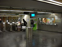
In the ticket area is a ceramic fresco, geographically depicting the period of reconquest during the Second World War from 1943 to 1945. Station layout
PlatformsBoulogne–Pont de Saint-Cloud is a station with a particular configuration. It has a central platform framed by the two tracks of the metro. Its shape and decoration are typical of the 1980s. The vertical walls are painted in a colour gradient ranging from off-white on the east side, through orange to burgundy on the west side, and support a horizontal ceiling painted white. The advertising frames are metallic, and the name of the station is inscribed in Parisine font on enamelled plates. The Motte style seats are orange on circular benches treated in flat white tiles, which are surmounted by orange poles each comprising three globes for lighting and are of the same model as those illuminating the platforms of the Bobigny - Pablo Picasso station on line 5 as well as those of the Le Kremlin-Bicêtre stations, Villejuif - Paul Vaillant-Couturier and Villejuif - Louis Aragon on line 7. The station is devoid of a rear station due to the lack of space due to its proximity to the Seine, so the manoeuvres are executed in front of the station. The trains are thus received alternately on the two tracks and leave directly by turning back. For the same reason, the station has no train garage. Other connectionsThe station is connected remotely with the Île-de-France tramway Line 2 at the Gare du Pont de Saint-Cloud, located on the other side of the Pont de Saint-Cloud bridge. In addition, it is served by lines 52, 72, 126, 160, 175, 260 and 467 of the RATP Bus Network, by line 460 of the Réseau de bus du Grand Versailles bus network and by line 17 of the Hourtoule transport company. Gallery
References
Wikimedia Commons has media related to Boulogne - Pont de Saint-Cloud (Paris Metro). |
||||||||||||||||||||||||||||||||||||||||||||||||||||||||||


