Share to: share facebook share twitter share wa share telegram print page

Calhoun County, West Virginia

Calhoun County
The Calhoun County Courthouse in Grantsville
Flag of Calhoun County
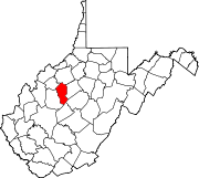
Map of West Virginia highlighting Calhoun County
Location within the U.S. state of West Virginia
Map of the United States highlighting West Virginia
West Virginia's location within the U.S.
Coordinates: 38°50′N 81°07′W / 38.84°N 81.12°W / 38.84; -81.12
Country United States
State West Virginia
FoundedMarch 5, 1856
Named forJohn C. Calhoun
SeatGrantsville
Largest townGrantsville
Area
 • Total281 sq mi (730 km2)
 • Land279 sq mi (720 km2)
 • Water1.4 sq mi (4 km2)  0.5%
Population
 (2020)
 • Total6,229
 • Estimate 
(2021)
6,176 Decrease
 • Density22/sq mi (8.6/km2)
Time zoneUTC−5 (Eastern)
 • Summer (DST)UTC−4 (EDT)
Congressional district1st
Websitewww.calhouncounty.wv.gov

Calhoun County is a county in the U.S. state of West Virginia. As of the 2020 census, the population was 6,229,[1] making it the third-least populous county in West Virginia. Its county seat is Grantsville.[2] The county was founded in 1856 and named for South Carolina politician John C. Calhoun.[3][4]

Geography

According to the United States Census Bureau, the county has a total area of 281 square miles (730 km2), of which 279 square miles (720 km2) is land and 1.4 square miles (3.6 km2) (0.5%) is water.[5]

In 1863, West Virginia's counties were divided into civil townships, with the intention of encouraging local government. This proved impractical in the heavily rural state, and in 1872 the townships were converted into magisterial districts.[6] Calhoun County was divided into five districts: Centre, Lee, Sheridan, Sherman, and Washington. Between 1980 and 1990, the county was reorganized into five new magisterial districts: District 1, District 2, District 3, District 4, and District 5.[7]

Major highways

Adjacent counties

Demographics

Historical population
CensusPop.Note
18602,502
18702,93917.5%
18806,072106.6%
18908,15534.3%
190010,26625.9%
191011,2589.7%
192010,268−8.8%
193010,8665.8%
194012,45514.6%
195010,259−17.6%
19607,948−22.5%
19707,046−11.3%
19808,25017.1%
19907,885−4.4%
20007,582−3.8%
20107,6270.6%
20206,229−18.3%
2021 (est.)6,176[8]−0.9%
U.S. Decennial Census[9]
1790–1960[10] 1900–1990[11]
1990–2000[12] 2010–2020[1]

2010 census

As of the 2010 United States census, there were 7,627 people, 3,268 households, and 2,178 families living in the county.[13] The population density was 27.3 inhabitants per square mile (10.5/km2). There were 3,963 housing units at an average density of 14.2 per square mile (5.5/km2).[14] The racial makeup of the county was 98.4% white, 0.3% American Indian, 0.2% black or African American, 0.2% Asian, 0.2% from other races, and 0.7% from two or more races. Those of Hispanic or Latino origin made up 0.7% of the population.[13] In terms of ancestry, 22.4% were German, 21.3% were Irish, 7.7% were American, 7.3% were English, and 5.7% were Dutch.[15]

Of the 3,268 households, 26.5% had children under the age of 18 living with them, 51.7% were married couples living together, 9.7% had a female householder with no husband present, 33.4% were non-families, and 28.5% of all households were made up of individuals. The average household size was 2.33 and the average family size was 2.80. The median age was 45.1 years.[13]

The median income for a household in the county was $26,922 and the median income for a family was $34,897. Males had a median income of $32,229 versus $20,707 for females. The per capita income for the county was $17,121. About 13.2% of families and 20.5% of the population were below the poverty line, including 35.0% of those under age 18 and 6.6% of those age 65 or over.[16]

2000 census

As of the census of 2000, there were 7,582 people, 3,071 households, and 2,201 families living in the county. The population density was 27 people per square mile (10 people/km2). There were 3,848 housing units at an average density of 14 per square mile (5.4/km2). The racial makeup of the county was 98.91% White, 0.11% Black or African American, 0.30% Native American, 0.11% Asian, 0.01% Pacific Islander, 0.13% from other races, and 0.44% from two or more races. 0.55% of the population were Hispanic or Latino of any race.

There were 3,071 households, out of which 28.90% had children under the age of 18 living with them, 57.00% were married couples living together, 10.30% had a female householder with no husband present, and 28.30% were non-families. 24.90% of all households were made up of individuals, and 12.30% had someone living alone who was 65 years of age or older. The average household size was 2.46 and the average family size was 2.91.

In the county, the population was spread out, with 22.40% under the age of 18, 8.00% from 18 to 24, 25.90% from 25 to 44, 27.10% from 45 to 64, and 16.70% who were 65 years of age or older. The median age was 41 years. For every 100 females there were 99.70 males. For every 100 females age 18 and over, there were 98.30 males.

The median income for a household in the county was $21,578, and the median income for a family was $26,701. Males had a median income of $25,609 versus $14,304 for females. The per capita income for the county was $11,491. About 19.10% of families and 25.10% of the population were below the poverty line, including 29.40% of those under age 18 and 24.90% of those age 65 or over.

Politics

Calhoun County is a historically secessionist and Democratic county, which never voted Republican between the first Reconstruction election and Dwight D. Eisenhower’s landslide win in 1956.[17] Since then it has consistently followed the statewide results of West Virginia, from Democratic-leaning to Republican bastion in the twenty-first century.

United States presidential election results for Calhoun County, West Virginia[18]
Year Republican Democratic Third party
No.  % No.  % No.  %
2020 2,364 79.57% 568 19.12% 39 1.31%
2016 2,035 77.14% 456 17.29% 147 5.57%
2012 1,319 59.68% 818 37.01% 73 3.30%
2008 1,366 56.24% 993 40.88% 70 2.88%
2004 1,588 54.97% 1,266 43.82% 35 1.21%
2000 1,425 54.49% 1,112 42.52% 78 2.98%
1996 1,000 36.70% 1,402 51.45% 323 11.85%
1992 1,095 33.51% 1,627 49.79% 546 16.71%
1988 1,395 45.63% 1,644 53.78% 18 0.59%
1984 1,765 53.88% 1,473 44.96% 38 1.16%
1980 1,606 46.67% 1,717 49.90% 118 3.43%
1976 1,283 37.12% 2,173 62.88% 0 0.00%
1972 1,992 56.59% 1,528 43.41% 0 0.00%
1968 1,612 44.63% 1,682 46.57% 318 8.80%
1964 1,275 32.68% 2,626 67.32% 0 0.00%
1960 1,946 49.63% 1,975 50.37% 0 0.00%
1956 2,094 52.06% 1,928 47.94% 0 0.00%
1952 2,101 49.56% 2,138 50.44% 0 0.00%
1948 1,549 42.08% 2,126 57.76% 6 0.16%
1944 1,687 42.81% 2,254 57.19% 0 0.00%
1940 1,891 39.70% 2,872 60.30% 0 0.00%
1936 1,733 33.88% 3,369 65.87% 13 0.25%
1932 1,564 33.11% 3,139 66.45% 21 0.44%
1928 1,745 44.27% 2,179 55.28% 18 0.46%
1924 1,399 38.51% 2,231 61.41% 3 0.08%
1920 1,671 48.48% 1,773 51.44% 3 0.09%
1916 936 41.31% 1,317 58.12% 13 0.57%
1912 575 23.84% 1,349 55.93% 488 20.23%

Attractions

Calhoun County is home to four public parks: The Upper West Fork Park in Chloe on West Virginia Route 16, the West Fork Park in Arnoldsburg on U.S. Route 33, Mt. Zion Park on West Virginia Route 16, and Calhoun County Park on West Virginia Route 16.

Calhoun is home to the annual West Virginia Wood Festival, the West Virginia Molasses Festival in September.

Calhoun County was home to one of the last 500 drive-in theaters in the nation, now closed. Calhoun also has one of the largest genealogy collections in the state, housed at Calhoun County Library. The library is also home to the "West Virginia Room" which includes books on West Virginia and by West Virginians.

Communities

Town

Magisterial districts

  • District 1
  • District 2
  • District 3
  • District 4
  • District 5

Unincorporated communities

See also

References

  1. ^ a b "State & County QuickFacts". United States Census Bureau. Retrieved October 18, 2022.
  2. ^ "Find a County". National Association of Counties. Archived from the original on May 31, 2011. Retrieved June 7, 2011.
  3. ^ "Calhoun County history sources". Archived from the original on January 17, 2013. Retrieved January 17, 2013.
  4. ^ "West Virginia County Histories". Archived from the original on March 20, 2008. Retrieved March 19, 2008.
  5. ^ "2010 Census Gazetteer Files". United States Census Bureau. August 22, 2012. Retrieved July 23, 2015.
  6. ^ Otis K. Rice & Stephen W. Brown, West Virginia: A History, 2nd ed., University Press of Kentucky, Lexington (1993), p. 240.
  7. ^ United States Census Bureau, U.S. Decennial Census, Tables of Minor Civil Divisions in West Virginia, 1870–2010.
  8. ^ "Annual Estimates of the Resident Population for Counties: April 1, 2020 to July 1, 2021". Retrieved October 18, 2022.
  9. ^ "U.S. Decennial Census". United States Census Bureau. Retrieved January 9, 2014.
  10. ^ "Historical Census Browser". University of Virginia Library. Retrieved January 9, 2014.
  11. ^ "Population of Counties by Decennial Census: 1900 to 1990". United States Census Bureau. Retrieved January 9, 2014.
  12. ^ "Census 2000 PHC-T-4. Ranking Tables for Counties: 1990 and 2000" (PDF). United States Census Bureau. Archived (PDF) from the original on October 9, 2022. Retrieved January 9, 2014.
  13. ^ a b c "DP-1 Profile of General Population and Housing Characteristics: 2010 Demographic Profile Data". United States Census Bureau. Archived from the original on February 13, 2020. Retrieved April 3, 2016.
  14. ^ "Population, Housing Units, Area, and Density: 2010 - County". United States Census Bureau. Archived from the original on February 13, 2020. Retrieved April 3, 2016.
  15. ^ "DP02 SELECTED SOCIAL CHARACTERISTICS IN THE UNITED STATES – 2006-2010 American Community Survey 5-Year Estimates". United States Census Bureau. Archived from the original on February 13, 2020. Retrieved April 3, 2016.
  16. ^ "DP03 SELECTED ECONOMIC CHARACTERISTICS – 2006-2010 American Community Survey 5-Year Estimates". United States Census Bureau. Archived from the original on February 13, 2020. Retrieved April 3, 2016.
  17. ^ Menendez, Albert J.; The Geography of Presidential Elections in the United States, 1868-2004, pp. 334-335 ISBN 0786422173
  18. ^ Leip, David. "Dave Leip's Atlas of U.S. Presidential Elections". uselectionatlas.org. Retrieved March 27, 2018.

External links

38°50′N 81°07′W / 38.84°N 81.12°W / 38.84; -81.12

Read more information:

Russian newspaper The BellTypeOnline newspaperFormatElectronic publishingFounder(s)Yelizaveta Osetinskaya, Elizaveta Osetinskaya, Irina Malkova and Peter Mironenko[1]Founded2017; 7 years ago (2017)[1]LanguageRussian, EnglishCountryRussiaWebsiteen.thebell.ioMedia of RussiaList of newspapers The Bell is an Independent online newspaper in Russia, described by Bloomberg as one of the last Russian independent news sources still standing.[1] History The Bell w…

Contoh tipikal dari ruang kompleks adalah garis proyektif kompleks. Ini dapat dilihat baik sebagai bola, lipatan halus yang timbul dari geometri diferensial, atau bola Riemann, perpanjangan dari bidang kompleks dengan menambahkan titik tak terhingga.Artikel atau sebagian dari artikel ini mungkin diterjemahkan dari Complex geometry di en.wikipedia.org. Isinya masih belum akurat, karena bagian yang diterjemahkan masih perlu diperhalus dan disempurnakan. Jika Anda menguasai bahasa aslinya, harap pe…

Dari kanan ke kiri: patung Isis, suaminya Osiris, dan putra mereka Horus, protagonis mitos Osiris. Patung ini berasal dari masa Dinasti ke-22 Mitos Osiris adalah kisah yang paling rumit dan berpengaruh dalam mitologi Mesir kuno. Mitos ini berkisah tentang pembunuhan dewa Osiris, penguasa awal Mesir Kuno, dan dampak dari pembunuhan tersebut. Pembunuh Osiris adalah saudaranya sendiri, yaitu Set, yang kemudian merebut takhta Osiris. Sementara itu, istri Osiris, Isis, menghidupkan kembali tubuh suam…

Artikel ini memberikan informasi dasar tentang topik kesehatan. Informasi dalam artikel ini hanya boleh digunakan untuk penjelasan ilmiah; bukan untuk diagnosis diri dan tidak dapat menggantikan diagnosis medis. Wikipedia tidak memberikan konsultasi medis. Jika Anda perlu bantuan atau hendak berobat, berkonsultasilah dengan tenaga kesehatan profesional. Penyakit paru obstruktif kronisPatologi kasar yang menunjukkan emfisema tipe sentrilobular yang merupakan ciri dari merokok. Tampilan jarak deka…

Dorcadion songaricum Klasifikasi ilmiah Kerajaan: Animalia Filum: Arthropoda Kelas: Insecta Ordo: Coleoptera Famili: Cerambycidae Subfamili: Lamiinae Tribus: Dorcadiini Genus: Dorcadion Spesies: Dorcadion songaricum Dorcadion songaricum adalah spesies kumbang tanduk panjang yang tergolong famili Cerambycidae. Spesies ini juga merupakan bagian dari genus Dorcadion, ordo Coleoptera, kelas Insecta, filum Arthropoda, dan kingdom Animalia. Larva kumbang ini biasanya mengebor ke dalam kayu dan dapat m…

LabneLabne dengan minyak zaitunNama lainchak(k)a, yogurt Yunani, labneh, suzma, keju yogurtJenisYogurtTempat asalTimur Tengah atau Asia TengahDaerahAsia Barat, Selatan, dan Tengah; Eropa TenggaraBahan utamaYogurtEnergi makanan(per porsi )457 kJ (109 kcal) per 100 g[1] kkalSunting kotak info • L • BBantuan penggunaan templat ini  Media: Labne Labne, yogurt Yunani,[2] keju yogurt, atau labneh (Arab: لبنةcode: ar is deprecated labnah, dibaca LEB-neigh…

Fortified house and National Monument, County Louth, Ireland The MintNative name Irish: An MiontaTypeFortified houseLocationTholsel Street, Carlingford,County Louth, IrelandCoordinates54°02′25″N 6°11′11″W / 54.040144°N 6.186272°W / 54.040144; -6.186272AreaCooley PeninsulaBuilt15th/16th centuryOwnerState National monument of IrelandOfficial nameThe MintReference no.242 Location of The Mint in Ireland The Mint is a fortified house and National Monument loca…

ويست بالم بيتش   الاسم الرسمي (بالإنجليزية: West Рalm Beach)‏    الإحداثيات 26°42′35″N 80°03′51″W / 26.709722222222°N 80.064166666667°W / 26.709722222222; -80.064166666667  [1] تاريخ التأسيس 1884  تقسيم إداري  البلد الولايات المتحدة[2][3]  التقسيم الأعلى مقاطعة بالم بيتش  عاصمة …

منتخب جنوب إفريقيا لكرة القدم (بالأفريقانية: Suid-Afrikaanse nasionale sokkerspan)‏  معلومات عامة اللقب Bafana Bafana (الأولاد) بلد الرياضة  جنوب إفريقيا الفئة كرة القدم للرجال  رمز الفيفا RSA الاتحاد اتحاد جنوب أفريقيا لكرة القدم كونفدرالية كاف (أفريقيا) الملعب الرئيسي ملعب البنك الوطني ال…

Ini adalah nama Korea; marganya adalah Son. Son Ho-junLahir27 Juni 1984 (umur 39)Gwangju, Korea SelatanNama lainSon Ho-joonPendidikanUniversitas Songwon - Department of EntertainmentPekerjaanAktorTahun aktif2006 - sekarangAgenYG EntertainmentNama KoreaHangul손호준 Alih AksaraSon Ho-junMcCune–ReischauerSon Ho-chun Son Ho-jun (lahir 27 Juni 1984) adalah penyanyi dan aktor asal Korea Selatan. Sebelum debutnya di dunia akting, Son memulai debutnya di dunia hiburan pada tahun 2007…

Pour les articles homonymes, voir Lafayette. Émetteur de LafayetteVue générale de l'émetteur de Lafayette.PrésentationType Émetteur d'ondes radioélectriques 24000 m 16 décembre 1920 : inauguration 1923 : station Bordeaux -Lafayette 1924 : Bordeaux-La Fayette-PTTDestination initiale antenne en nappe (400 m x 1200 m) suspendu sur 8 pylônes, émetteur à arc 1 MW (1920-1923) puis alternateur HF 500 kW (1923-1938)Destination actuelle disparuIngénieur Plan des installations c…

2012 2022 Élections législatives de 2017 en Charente-Maritime 5 sièges de députés à l'Assemblée nationale 11 et 18 juin 2017 Type d’élection Élections législatives Campagne 22 mai au 10 juin12 juin au 16 juin Débat(s) 1re circonscription : mardi 13 juin sur France Bleu La Rochelle-Sud Ouest[1]4e circonscription : dimanche 14 mai sur France 3 Poitou-Charentes[2] Corps électoral et résultats Population 637 089 Inscrits 491 038 Votants au 1er tour 247 17…

Lambang Peta Data dasar Bundesland: Bayern Regierungsbezirk: Oberfranken Ibu kota: Bayreuth Wilayah: 1.273,09 km² Penduduk: 108.923 (30 Juni 2005) Kepadatan penduduk: 86 jiwa per km² Nomor pelat kendaraan bermotor: BT Kreisschlüssel: 09 4 72 Pembagian administratif: 33 Gemeinden Alamatkantor bupati: Markgrafenallee 595448 Bayreuth Situs web resmi: www.landkreis-bayreuth.de Alamat e-mail: poststelle@lra-bt.bayern.de Politik Bupati: Klaus-Günter Dietel, CSU Bayreuth adalah sebuah distrik (Land…

American baseball player and manager (1878-1970) For other people named Fred Mitchell, see Fred Mitchell (disambiguation). Baseball player Fred MitchellPitcher / Catcher / First baseman / ManagerBorn: (1878-06-05)June 5, 1878Cambridge, Massachusetts, U.S.Died: October 13, 1970(1970-10-13) (aged 92)Newton, Massachusetts, U.S.Batted: RightThrew: RightMLB debutApril 17, 1901, for the Boston AmericansLast MLB appearanceJune 15, 1913, for the Boston BravesMLB statis…

Pour les articles homonymes, voir Ramillies. Cet article est une ébauche concernant une localité brabançonne wallonne. Vous pouvez partager vos connaissances en l’améliorant (comment ?) selon les recommandations des projets correspondants. Ramillies Vue générale du village, avec l'église Saint-Martin Héraldique Administration Pays Belgique Région  Région wallonne Communauté  Communauté française Province  Province du Brabant wallon Arrondissement Nivelles Bourg…

Artikel ini sebatang kara, artinya tidak ada artikel lain yang memiliki pranala balik ke halaman ini.Bantulah menambah pranala ke artikel ini dari artikel yang berhubungan atau coba peralatan pencari pranala.Tag ini diberikan pada Januari 2023. Sebuah aturan sistem tenaga listrik adalah serangkaian spesifikasi teknis yang harus dicapai oleh semua fasilitas yang terhubung ke sistem tenaga listrik, untuk memastikan keamanan, keselamatan, dan keekonomian dari sistem. Fasilitas-fasilitas tersebut da…

Manufacturer of guitars Ovation Guitar CompanyCompany typeSubsidiaryIndustryMusical instrumentsPredecessorOvation Instruments, a division of Kaman Aircraft[1][2] (c. 1964)[history 1][history 2]Foundedc. 1965,[citation needed] New Hartford, ConnecticutFounderCharles KamanHeadquartersNew Hartford, ConnecticutProducts Current: Acoustic and classical guitars, acoustic basses, mandolins, ukuleles [3] Former: Electric guitars (1967–80)[…

Ini adalah nama Maluku, (Ambon), marganya adalah Pesulima Broery MarantikaLahirSimon Dominggus Pesulima(1942-06-25)25 Juni 1942Ambon, Masa Pendudukan JepangMeninggal7 April 2000(2000-04-07) (umur 57)Depok, Jawa Barat, IndonesiaNama lainBroeryPekerjaanpenyanyi, aktorSuami/istriAstrid Kayhatu Anita Sarawak ​(m. 1981⁠–⁠1985)​ Wanda Irene Latuperissa ​ ​(m. 1989)​Anak3Orang tuaGijsberth Pesulima Wilmintje M…

Artikel ini sebatang kara, artinya tidak ada artikel lain yang memiliki pranala balik ke halaman ini.Bantulah menambah pranala ke artikel ini dari artikel yang berhubungan atau coba peralatan pencari pranala.Tag ini diberikan pada November 2022. Javier Garrido Informasi pribadiNama lengkap Javier Garrido BehobideTanggal lahir 15 Maret 1985 (umur 39)Tempat lahir Irun, SpanyolTinggi 1,78 m (5 ft 10 in)[1]Posisi bermain Bek kiriInformasi klubKlub saat ini AEK LarnacaNomo…

Questa voce sull'argomento calciatori tedeschi è solo un abbozzo. Contribuisci a migliorarla secondo le convenzioni di Wikipedia. Segui i suggerimenti del progetto di riferimento. Patrick Funk Nazionalità  Germania Altezza 178 cm Peso 76 kg Calcio Ruolo Centrocampista Squadra Essingen Carriera Squadre di club1 2008-2011 Stoccarda II72 (7)2010 Stoccarda9 (1)2011-2013→  St. Pauli56 (0)2014-2018 Wehen Wiesbaden108 (3)2018-2019 Aalen32 (0)2019- Essingen? (?) Na…

Kembali kehalaman sebelumnya