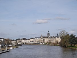
Part of Château-Gontier-sur-Mayenne in Pays de la Loire, France
Château-Gontier (French pronunciation: [ʃɑto ɡɔ̃tje] ⓘ commune in the Mayenne department in north-western France .[ 2] Château-Gontier-sur-Mayenne .[ 3]
Geography
It is about 30 km (19 mi) south of Laval , the préfecture of the department of Mayenne. Château-Gontier is home to the Refuge de l'Arche , also known as the Ark Refuge [1] , a refuge for abandoned or mistreated animals.
History
There are chalybeate springs close to the town. Château-Gontier owes its origin and its name to a castle erected in the first half of the 11th century by Gunther, the steward of Fulk Nerra of Anjou, on the site of a farm belonging to the monks of St Aubin d’Angers. On the extinction of the family, the lordship was assigned by Louis XI of France to Philippe de Comines . The town suffered severely during the wars of the League . In 1793 it was occupied by the Vendeans .[ 5]
Culture and heritage
The following buildings have been listed as historical monuments :
The ruined 13th century castle[ 6]
The 11th century church of Saint John Baptist[ 7]
The church of the Holy Trinity[ 8]
The 12th century chapel of Le Genneteil[ 9]
The 16th century chapel of Le Moulinet[ 10]
The 17th century Hôtel de Lantivy[ 11]
People
Climate
Climate data for Château-Gontier (Coudray ) (1996–2020 normals, extremes 1972–present)
Month
Jan
Feb
Mar
Apr
May
Jun
Jul
Aug
Sep
Oct
Nov
Dec
Year
Record high °C (°F)
16.1
21.9
25.5
29.2
34.0
38.4
39.8
39.1
36.6
30.6
21.5
18.0
39.8
Mean daily maximum °C (°F)
8.8
10.3
13.5
17.0
20.5
24.0
25.9
25.9
23.0
17.7
12.4
9.3
17.4
Daily mean °C (°F)
5.5
6.2
8.5
11.0
14.5
17.8
19.5
19.4
16.7
13.1
8.6
5.9
12.2
Mean daily minimum °C (°F)
2.3
2.0
3.4
5.0
8.6
11.6
13.1
13.0
10.4
8.4
4.9
2.6
7.1
Record low °C (°F)
−16.0
−13.2
−11.9
−4.0
−2.2
0.2
5.0
4.9
1.0
−3.5
−6.8
−9.4
−16.0
Average precipitation mm (inches)
69.8
56.1
50.2
52.6
58.5
53.1
46.2
43.2
61.9
71.3
76.6
78.9
718.4
Average precipitation days (≥ 1.0 mm)
12.1
10.0
9.5
9.6
9.6
7.2
6.4
7.1
7.9
10.9
11.7
12.3
114.3
Source: Meteociel[ 12]
See also
References
^ Téléchargement du fichier d'ensemble des populations légales en 2019 , INSEE ^ Des villages de Cassini aux communes d'aujourd'hui : Commune data sheet Château-Gontier , EHESS (in French) .^ Arrêté préfectoral 14 November 2018 (in French) ^ public domain : Chisholm, Hugh , ed. (1911). "Château-Gontier ". Encyclopædia Britannica ^ Base Mérimée : Château (restes) , Ministère français de la Culture. (in French) ^ Base Mérimée : Eglise Saint-Jean-Baptiste , Ministère français de la Culture. (in French) ^ Base Mérimée : Eglise de la Trinité , Ministère français de la Culture. (in French) ^ Base Mérimée : Chapelle du Genneteil , Ministère français de la Culture. (in French) ^ Base Mérimée : Chapelle du Moulinet (ancienne) , Ministère français de la Culture. (in French) ^ Base Mérimée : Hôtel dit de Lantivy , Ministère français de la Culture. (in French) ^ "Normales et records pour Coudray (53)" . Meteociel. Retrieved 20 November 2024 .
International National Geographic


