|
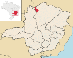
Chapada Gaúcha Chapada Gaúcha is a municipality in the northern region of Minas Gerais, Brazil. The population in 2020 was 13,953 in an area of 3,215 km2.[1] The elevation of the municipal seat is 872 meters. It became a municipality in 1997. The postal code (CEP) is 39314-000. GeographyChapada Gaúcha is part of the statistical microregion of Januária. It is connected by poor roads to Arinos and to Januária. It lies in an extensive agricultural area on highlands south of the boundary with the state of Bahia. The Grande Sertão Veredas National Park lies a few kilometers from the municipal seat. See Braziltour[permanent dead link] for information about the park. The park is not open to visitors and has no facilities. It was created in 1989 and has an area of 231,668.00 hectares. Distances
ClimateThe climate is semi-humid. The dry season is well-defined, and occurs between the months of May and November. The rainy season takes place from November through April. The average annual temperature is around 21 °C – with an average annual high of 30 °C, and a low of 18 °C. June is normally the coldest month of the year. EconomyThe main economic activities are cattle raising (65,000 head in 2006) and farming with large production of soybeans (9,000 ha.), corn, and rice. In the urban area there were no financial institutions as of 2006[update]. There were 134 automobiles, giving a ratio of about one automobile for every 80 inhabitants. The Gross Domestic Product was R$36,891,000.00 (2005) a year, which was mainly generated by services and agriculture. Health care was provided by 7 public health clinics. There were no hospitals as of 2005[update]. Farm Data for 2006
Municipal Human Development Index Chapada Gaúcha was in the bottom tier of the poorest municipalities in Minas Gerais
See alsoReferencesExternal links |