Share to: share facebook share twitter share wa share telegram print page

Charlotte County, Florida

Charlotte County
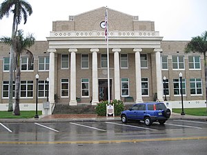
The Old Charlotte County Courthouse at Punta Gorda in April 2010.
Official seal of Charlotte County
Official logo of Charlotte County
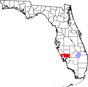
Map of Florida highlighting Charlotte County
Location within the U.S. state of Florida
Map of the United States highlighting Florida
Florida's location within the U.S.
Coordinates: 26°54′N 81°57′W / 26.9°N 81.95°W / 26.9; -81.95
Country United States
State Florida
FoundedApril 23, 1921
Named forCharlotte Harbor
SeatPunta Gorda
Largest communityPort Charlotte
Area
 • Total858 sq mi (2,220 km2)
 • Land680 sq mi (1,800 km2)
 • Water178 sq mi (460 km2)  20.7%
Population
 (2020)
 • Total186,847[1]
 • Density275/sq mi (106/km2)
Time zoneUTC−5 (Eastern)
 • Summer (DST)UTC−4 (EDT)
Congressional district17th
Websitewww.charlottecountyfl.gov

Charlotte County is a U.S. county located in southwestern Florida. As of the 2020 census, the population was 186,847.[2] Its county seat is Punta Gorda.[3]

Charlotte County comprises the Punta Gorda, FL Metropolitan Statistical Area, which is included in the North Port-Bradenton, Florida Combined Statistical Area.

History

Charlotte County was established April 23, 1921. It was named for the Bay of Charlotte Harbor. "Charlotte" came from "Carlota" (Spanish). In 1565, the Spanish named "Bahia de Carlota", followed by the English in 1775 who named the area Charlotte Harbor in tribute to Queen Charlotte. Punta Gorda is the only incorporated city in Charlotte County.

On August 13, 2004, Charlotte County, Hurricane Charley came ashore near Port Charlotte as a Category 4 hurricane. On September 28, 2022, Charlotte County was struck by Hurricane Ian, which made a second landfall near the city of Punta Gorda, Florida.[4]

Historic places

Historic places in Charlotte County include the Old Charlotte County Courthouse as well as those on the List of Registered Historic Places in Charlotte County.

Geography

According to the U.S. Census Bureau, the county has a total area of 858 square miles (2,220 km2), of which 680 square miles (1,800 km2) is land and 178 square miles (460 km2) (20.7%) is water.[5] Charlotte Harbor Estuary is an important natural preserve and one of the most productive in Florida.

The Punta Gorda, Florida Metropolitan Statistical Area, consisting of Charlotte County, was defined by the U.S. Office of Management and Budget in 1992.[6]


Adjacent counties

National protected area

Demographics

Historical population
CensusPop.Note
19304,013
19403,663−8.7%
19504,28617.0%
196012,594193.8%
197027,559118.8%
198058,460112.1%
1990110,97589.8%
2000141,62727.6%
2010159,97813.0%
2020186,84716.8%
2023 (est.)206,134[7]10.3%
U.S. Decennial Census[8]
1790-1960[9] 1900-1990[10]
1990-2000[11] 2010-2015[2]
Charlotte County racial composition
(NH = Non-Hispanic)[a]
Race Pop 2010[14] Pop 2020[15] % 2010 % 2020
White (NH) 137,628 153,700 86.03% 82.26%
Black or African American (NH) 8,622 8,870 5.39% 4.75%
Native American or Alaska Native (NH) 348 385 0.22% 0.21%
Asian (NH) 1,884 2,566 1.18% 1.37%
Pacific Islander (NH) 49 63 0.03% 0.03%
Some Other Race (NH) 184 782 0.12% 0.42%
Mixed/Multi-Racial (NH) 2,050 6,402 1.28% 3.43%
Hispanic or Latino 9,213 14,079 5.76% 7.54%
Total 159,978 186,847

As of the 2020 United States census, there were 186,847 people, 79,789 households, and 51,016 families residing in the county.

As of the census[16] of 2010, there were 159,978 people, 73,370 households, and 44,130 families residing in the county. The population density was 234 people per square mile (90 people/km2). There were 100,632 housing units at an average density of 115 per square mile (44/km2). The racial makeup of the county was 90.05% White, 5.68% Black or African American, 0.26% Native American, 1.19% Asian, 0.04% Pacific Islander, 1.10% from other races, and 1.67% from two or more races. 5.76% of the population were Hispanic or Latino of any race. 92.3% spoke only English at home. 3.0% of the population spoke Spanish at home and 1.1% French.

There were 73,370 households, out of which 17.66% had children under the age of 18 living with them, 59.20% were married couples living together, 7.20% had a female householder with no husband present, and 30.90% were non-families. 26.00% of all households were made up of individuals, and 16.70% had someone living alone who was 65 years of age or older. The average household size was 2.18 and the average family size was 2.56.

In the county, the population was spread out, with 14.30% under the age of 18, 5.38% from 18 to 24, 6.99% from 25 to 34, 39.21% from 35 to 64, and 34.12% who were 65 years of age or older (making this the county with the highest percentage of people over 65 in America). The median age was 56.43 years. For every 100 females there were 94.58 males.

The median income for a household (2007-2011) in the county was $45,112; median income for families (2007-2011) was $47,415. Males (2011) had a median income of $27,352 versus $26,861 for females. The per capita income for the county was $28,875. About 5.30% of families and 11.9% of the population were below the poverty line, including 17.40% of those under age 18 and 5.60% of those age 65 or over.

According to an October 2001 Census Brief of the 2000 Census, Charlotte County had the highest median age of any U.S. county with a population of more than 100,000 people at 54.3.[17] The median age in 2010 for Charlotte County was 55.9 years, second only to Sumter County in Florida.

Government and politics

Charlotte County Fire & EMS apparatus at Fawcett Memorial Hospital

The county is governed by a five-person Commission, all of them elected to represent districts within the county for a four-year term. The elections are partisan according to political party affiliation and primaries are held months earlier in the event there are numerous candidates. All registered voters in the county are allowed to vote for a candidate Commissioner in each the five districts, not just the voters living in a particular district.

The five current Commissioners for Charlotte County, Florida and terms of office expirations:

  • Ken Doherty (R), District 1, November 3, 2020[18]
  • Christopher Constance (R), District 2, November 8, 2022[19]
  • Bill Truex (R) District 3, November 3, 2020[18]
  • Stephen R. Deutsch (R) District 4, November 8, 2022[19]
  • Joe Tiseo (R) District 5, November 3, 2020[18]

Charlotte County, as is typical for the southwestern Florida coast, became and remained a solidly Republican county in the years following the Second World War. No Democrat has won the county since Lyndon Johnson did so during his 1964 landslide,[20] the only time a Democrat has carried the county since Franklin D. Roosevelt in 1944. In the last 60 years, Bill Clinton in 1992 and 1996 was the only Democrat not being outvoted by an absolute majority due to the appeal of Ross Perot. Charlotte resisted George Wallace in the 1968 election to still return an absolute Republican majority, unlike several neighboring counties.

United States presidential election results for Charlotte County, Florida[21]
Year Republican Democratic Third party
No.  % No.  % No.  %
2020 73,243 62.84% 42,273 36.27% 1,042 0.89%
2016 60,218 61.96% 33,445 34.41% 3,524 3.63%
2012 47,996 56.52% 35,906 42.28% 1,021 1.20%
2008 45,205 52.87% 39,031 45.65% 1,263 1.48%
2004 44,428 55.68% 34,256 42.93% 1,102 1.38%
2000 35,428 52.96% 29,646 44.31% 1,826 2.73%
1996 27,847 44.18% 27,121 43.03% 8,059 12.79%
1992 24,311 39.17% 22,907 36.91% 14,846 23.92%
1988 28,893 63.98% 15,974 35.37% 292 0.65%
1984 27,486 70.85% 11,305 29.14% 2 0.01%
1980 20,486 64.62% 9,769 30.82% 1,445 4.56%
1976 12,703 54.44% 10,300 44.14% 330 1.41%
1972 12,888 76.64% 3,874 23.04% 55 0.33%
1968 6,056 50.58% 3,647 30.46% 2,270 18.96%
1964 4,163 46.29% 4,831 53.71% 0 0.00%
1960 3,026 60.92% 1,941 39.08% 0 0.00%
1956 1,589 63.11% 929 36.89% 0 0.00%
1952 1,134 58.79% 795 41.21% 0 0.00%
1948 559 44.09% 520 41.01% 189 14.91%
1944 404 33.86% 789 66.14% 0 0.00%
1940 407 30.90% 910 69.10% 0 0.00%
1936 548 41.20% 782 58.80% 0 0.00%
1932 396 29.33% 954 70.67% 0 0.00%
1928 593 55.73% 441 41.45% 30 2.82%
1924 167 31.21% 321 60.00% 47 8.79%

Voter Registration

Voter Registration and Party Membership as of March 31, 2022:[22]
Party Number of Votes Percentage
Republican 70,736 47.13%
No Party Affiliation 40,020 26.66%
Democratic 36,065 24.03%
Minor parties 3,275 2.18%
Total 150,096 100.0%

Economy

Charlotte County attracted plentiful new commercial developers and companies in 2023, continuing the county’s growth trend of the last several years. Most of the building activity is taking place within industrial areas surrounding Punta Gorda Airport, as much of the rest of the county’s land is zoned for residential use, and the land that is zoned commercial outside the airport area has insufficient acreage to support large-scale projects. "Charlotte County Florida. Your Business. Cleared for Takeoff".

Another program the Economic Development Department is working with is an affordable housing initiative called the “Live Local Act.”

The program was created by the Florida Legislature to fund and incentivize workforce housing.

“Affordable housing and workforce housing is an issue in Charlotte County, Sarasota County, Florida and the entire country,” he said. “People need someone where to live in order to work here.”

CCED has been holding workshops with the county’s large employers like hospitals, the school district, Cheney Brothers or the Sheriff’s Office. "Charlotte County Florida. Your Business. Cleared for Takeoff".

Education

Florida SouthWestern State College maintains a campus in the county. Southern Technical College operates a campus in the county. Charlotte County Public Schools administers all public schools from kindergarten through twelfth grade.

Western Michigan University operated a regional location in the county until August 2019 when they closed the school. AeroGuard Flight Training Center opened a flight school at the airport. The Airframe and Power Plant Program offered through Charlotte Technical College also operates at the airport.

Library

The Charlotte County Library System consists of 4 library branches.[23]

  • Port Charlotte Public Library
  • Punta Gorda Public Library
  • Englewood Charlotte Public Library
  • Mid-County Regional Library

The erection of the first library was in 1963.[24] In 1976, Charlotte County and Glades County joined to make the Charlotte-Glades Library System. One reason the counties paired together was due to the additional $50,000 in state aid to libraries who join to serve the public. Charlotte County was financially responsible in the relationship. In 2008 the two counties separated and reverted to providing services to residents and visitors of their own communities.[25] The newest addition to the library system was an expansion to the Englewood Branch; the new building created is an additional 6,500 square feet. This provides more space for the youth services department, a new computer lab, and an archives run by the historical department.[26]

Communities

City

Census-designated places (unincorporated)

Other unincorporated communities

Transportation

Airport

See also

Notes

  1. ^ Note: the US Census treats Hispanic/Latino as an ethnic category. This table excludes Latinos from the racial categories and assigns them to a separate category. Hispanics/Latinos can be of any race.[12][13]

References

  1. ^ "U.S. Census Bureau QuickFacts: Charlotte County, Florida". Census.gov. Retrieved May 5, 2021.
  2. ^ a b "State & County QuickFacts". United States Census Bureau. Archived from the original on February 21, 2016. Retrieved June 13, 2014.
  3. ^ "Find a County". National Association of Counties. Archived from the original on May 31, 2011. Retrieved June 7, 2011.
  4. ^ US Department of Commerce, NOAA. "Hurricane Ian: September 30, 2022". www.weather.gov. Retrieved February 22, 2023.
  5. ^ "US Gazetteer files: 2010, 2000, and 1990". United States Census Bureau. February 12, 2011. Retrieved April 23, 2011.
  6. ^ "Metro Area History 1950–2020". U.S. Census Bureau. March 2020. Row 4128. Retrieved July 28, 2023.
  7. ^ "Annual Estimates of the Resident Population for Counties: April 1, 2020 to July 1, 2023". United States Census Bureau. Retrieved March 31, 2024.
  8. ^ "U.S. Decennial Census". United States Census Bureau. Retrieved June 13, 2014.
  9. ^ "Historical Census Browser". University of Virginia Library. Archived from the original on August 11, 2012. Retrieved June 13, 2014.
  10. ^ "Population of Counties by Decennial Census: 1900 to 1990". United States Census Bureau. Retrieved June 13, 2014.
  11. ^ "Census 2000 PHC-T-4. Ranking Tables for Counties: 1990 and 2000" (PDF). United States Census Bureau. Retrieved June 13, 2014.
  12. ^ https://www.census.gov/ [not specific enough to verify]
  13. ^ "About the Hispanic Population and its Origin". www.census.gov. Retrieved May 18, 2022.
  14. ^ "Explore Census Data". data.census.gov. Retrieved May 27, 2022.
  15. ^ "Explore Census Data". data.census.gov. Retrieved May 27, 2022.
  16. ^ "U.S. Census website". United States Census Bureau. Retrieved May 14, 2011.
  17. ^ "Census 2000 Brief" (PDF). www.census.gov. Retrieved May 5, 2021.
  18. ^ a b c "Summary Results - Election Night Reporting". enr.electionsfl.org. Retrieved November 7, 2018.
  19. ^ a b "Summary Results - Election Night Reporting". enr.electionsfl.org. Retrieved November 7, 2018.
  20. ^ Sullivan, Robert David; ‘How the Red and Blue Map Evolved Over the Past Century’; America Magazine in The National Catholic Review; June 29, 2016
  21. ^ David Leip’s Atlas of U.S. Presidential Elections; 2016 Presidential General Election Data Graphs – Florida by County (and earlier election years)
  22. ^ "Sarasota County, FL : Supervisor of Elections". Sarasota County, FL : Supervisor of Elections. SOE Software Corporation. April 20, 2022. Retrieved April 20, 2022.
  23. ^ "Charlotte County Library System: Home Page". www2.youseemore.com.
  24. ^ "Charlotte County Government. Charlotte County Weekly Department Highlights" (PDF).
  25. ^ Charlotte County Government. Charlotte-Glades Library System Long-Range Plan of Service.
  26. ^ "Sweet Sparkman Architects. Englewood Charlotte Library".

External links

26°54′N 81°57′W / 26.90°N 81.95°W / 26.90; -81.95

Read more information:

Simplisia Simplicia TaksonomiKerajaanAnimaliaFilumArthropodaKelasInsectaOrdoLepidopteraFamiliNoctuidaeGenusSimplicia Guenée, 1854 Tata namaSinonim takson Libisosa Walker, 1859 Culicula Walker, 1863 Aginna Walker, 1865 Nabartha Moore, 1885 lbs Simplisia adalah genus ngengat serasah dari keluarga Erebidae. Genus ini ditemukan oleh Achille Guenée pada tahun 1854.[1][2] Deskripsi Palpinya berbentuk sabit, dengan sambungan kedua mencapai di atas puncak kepala. Sambungan ketiga panja…

AjibataKecamatanGapura selamat datang di Kecamatan AjibataPeta lokasi Kecamatan AjibataNegara IndonesiaProvinsiSumatera UtaraKabupatenTobaPemerintahan • CamatTigor SiraitPopulasi • Total7,668 (2.019) jiwaKode Kemendagri12.12.08 Kode BPS1206082 Luas72,80 km²Desa/kelurahan9 desa 1 kelurahan Ajibata adalah sebuah kecamatan di Kabupaten Toba, Sumatera Utara, Indonesia. Geografi Kecamatan Ajibata dan Danau Toba Kecamatan Ajibata memiliki wilayah seluas 72,8 km2.[1 …

Bintang Kranggan FCNama lengkapBintang Kranggan Football ClubBerdiri1986; 38 tahun lalu (1986)StadionLapangan Hankam KalimanggisJakarta Timur, DKI JakartaPemilikPT. Bintang KrangganKetuaFerry SyahputraLigaLiga 3 Bintang Kranggan FC (atau disingkat BKFC) adalah tim sepak bola Indonesia yang bermarkas di Lapangan Hankam Kalimanggis, Kota Jakarta Timur, DKI Jakarta. Tim ini berkompetisi di Liga 3 Zona DKI Jakarta.[1] Referensi ^ https://www.pssi.org/news/bintang-kranggan-siap-hadapi-pe…

Perkebunan teh di Goalpara, Sukabumi utara pada tahun 1923 Parahyangan (Sunda: ᮕᮛᮠᮡᮍᮔ᮪, Parahyangan) bisa disebut juga sebagai Priangan atau Preanger (Belanda: Preangercode: nl is deprecated ) adalah wilayah geobudaya dan pegunungan yang berpusat di provinsi Jawa Barat di Pulau Jawa, Indonesia.[1] Di sebelah barat, wilayah ini berbatasan dengan provinsi Banten, sebelah utara berbatasan dengan wilayah DKI Jakarta dan wilayah pesisir utara Jawa Barat, sebelah timur berbat…

Artikel ini tidak memiliki referensi atau sumber tepercaya sehingga isinya tidak bisa dipastikan. Tolong bantu perbaiki artikel ini dengan menambahkan referensi yang layak. Tulisan tanpa sumber dapat dipertanyakan dan dihapus sewaktu-waktu.Cari sumber: Divisi Barat Daya NBA – berita · surat kabar · buku · cendekiawan · JSTOR Divisi Barat Daya (Southwest Division) merupakan salah satu dari tiga divisi yang ada di Wilayah Barat National Basket Associat…

Pemandangan Panteli di Leros Leros (Greek: Λέροςcode: el is deprecated ) adalah sebuah pulau di Yunani. Pulau ini terletak di Laut Aegea bagian selatan. Terletak 317 kilometer dari pelabuhan Piraeus di Athena, dari mana dapat dicapai dengan naik feri 8,5 jam (atau dengan penerbangan 45 menit dari Athena). Leros adalah bagian dari unit regional Kalymnos. Pulau itu juga disebut dalam Italia: Lerocode: it is deprecated . Pada tahun 2011, pulau ini memiliki jumlah penduduk sebesar 7.917 jiwa da…

Pour les articles homonymes, voir Pellerin et Kim Jong-suk (homonymie). Fleur Pellerin Fleur Pellerin en 2015. Fonctions Ministre de la Culture et de la Communication 26 août 2014 – 11 février 2016(1 an, 5 mois et 16 jours) Président François Hollande Premier ministre Manuel Valls Gouvernement Valls II Prédécesseur Aurélie Filippetti Successeur Audrey Azoulay Secrétaire d'État chargée du Commerce extérieur, de la Promotion du tourisme et des Français de l'étranger 9…

State park in California, United States Robert Louis Stevenson State ParkOne of the peaks of Mount Saint HelenaShow map of CaliforniaShow map of the United StatesLocationSonoma and Napa counties, CaliforniaNearest cityCalistoga, CaliforniaCoordinates38°39′12″N 122°36′12″W / 38.653416°N 122.603406°W / 38.653416; -122.603406Governing bodyState of California California Historical LandmarkReference no.710[1] Robert Louis Stevenson State Park…

Major salivary gland in many animals Parotid and parotids redirect here. For the carotids, see Common carotid artery. For the amphibian skin gland, see Parotoid gland. Parotid glandLocation of the left parotid gland in humans (shown in green).ImageDetailsPart ofSalivary glandsSystemDigestive systemIdentifiersLatinglandula parotideaMeSHD010306TA98A05.1.02.003TA22800FMA59790Anatomical terminology[edit on Wikidata] The parotid gland is a major salivary gland in many animals. In humans, the two …

American scientific research institute (founded 1946) Not to be confused with SRA International. SRI InternationalEntrance to SRI International headquarters in Menlo ParkFormerlyStanford Research Institute (1946–1970)Company type501(c)(3) nonprofit scientific research instituteIndustryResearch and developmentFoundedMenlo Park, California(1946; 78 years ago (1946))FounderTrustees of Stanford UniversityHeadquartersMenlo Park, California, U.S.Area servedWorldwideKey peopleDavid …

Keuskupan Agung BaltimoreArchidioecesis BaltimorensisKatolik LokasiNegara Amerika SerikatWilayahKota Baltimore dan sembilan county di tengah dan barat Maryland Provinsi gerejawiBaltimoreStatistikLuas4.801 km2 (1.854 sq mi)Populasi- Total- Katolik(per 2012)3.148.690510,328 (16.2%)Paroki144InformasiDenominasiGereja Katolik RomaGereja sui iurisGereja LatinRitusRitus RomaPendirian6 November 1789 (234 tahun lalu)KatedralKatedral Maria Ratu KamiKonkatedralBasili…

Ruslan Effendy Kepala Staf Kodam II/SriwijayaMasa jabatan29 Maret 2023 – 1 April 2024 PendahuluIzak PangemananPenggantiAminton ManurungKomandan Korem 043/Garuda HitamMasa jabatan21 Januari 2022 – 29 Maret 2023 PendahuluDrajad Brima YogaPenggantiIwan Ma'ruf Zainudin Informasi pribadiLahir26 Januari 1967 (umur 57)Ambon, MalukuSuami/istriHenny Ruslan EffendyOrang tuaLettu Pol. (Purn.) Chusnein Eddy (ayah)Hj. Etty Litamahuputty (ibu)Alma materAkademi Militer (1991)Karier m…

Об экономическом термине см. Первородный грех (экономика). ХристианствоБиблия Ветхий Завет Новый Завет Евангелие Десять заповедей Нагорная проповедь Апокрифы Бог, Троица Бог Отец Иисус Христос Святой Дух История христианства Апостолы Хронология христианства Ранне…

This article does not cite any sources. Please help improve this article by adding citations to reliable sources. Unsourced material may be challenged and removed.Find sources: Częstochowa Voivodeship – news · newspapers · books · scholar · JSTOR (December 2009) (Learn how and when to remove this template message) Częstochowa VoivodeshipWojewództwo częstochowskieVoivodeship of Poland1975–1998Location within PolandCapitalCzęstochowaArea •…

Artikel ini perlu diwikifikasi agar memenuhi standar kualitas Wikipedia. Anda dapat memberikan bantuan berupa penambahan pranala dalam, atau dengan merapikan tata letak dari artikel ini. Untuk keterangan lebih lanjut, klik [tampil] di bagian kanan. Mengganti markah HTML dengan markah wiki bila dimungkinkan. Tambahkan pranala wiki. Bila dirasa perlu, buatlah pautan ke artikel wiki lainnya dengan cara menambahkan [[ dan ]] pada kata yang bersangkutan (lihat WP:LINK untuk keterangan lebih lanjut). …

Russian politician In this name that follows Eastern Slavic naming customs, the patronymic is Zhamalovich and the family name is Bifov. You can help expand this article with text translated from the corresponding article in Russian. (February 2024) Click [show] for important translation instructions. Machine translation, like DeepL or Google Translate, is a useful starting point for translations, but translators must revise errors as necessary and confirm that the translation is accurat…

علي فرقاني علي فرقاني مع شبيبة القبائل معلومات شخصية الميلاد 21 سبتمبر 1952 (العمر 71 سنة)أونان  [لغات أخرى]‏  الطول 1.72 م (5 قدم 7 1⁄2 بوصة) مركز اللعب وسط الجنسية الجزائر  معلومات النادي النادي الحالي منتخب الجزائر لكرة القدم للمحليين مسيرة الشباب سنوات فر…

Annibale MaffeiRitratto di Annibale Maffei, museo civico di Mirandola Viceré di SiciliaDurata mandato1714 –1718 Capo di StatoVittorio Amedeo II di Savoia PredecessoreCarlo Antonio Spinola SuccessoreGiovan Francesco di Bette Dati generaliProfessionegenerale Annibale MaffeiNascitaMirandola, 10 dicembre 1666 MorteTorino, 15 agosto 1735 Dati militariPaese servitoDucato di SavoiaRegno di Sardegna Forza armataEsercito sabaudo GradoGenerale ComandantiVittorio Amedeo II di …

Ytterbium(III) acetate Names Other names Ytterbium acetateYtterbium triacetate Identifiers CAS Number 20981-49-1 Y 3D model (JSmol) Interactive image ChemSpider 146917 ECHA InfoCard 100.040.109 EC Number 244-137-6 PubChem CID 167952 CompTox Dashboard (EPA) DTXSID90890790 InChI InChI=1S/3C2H4O2.Yb/c3*1-2(3)4;/h3*1H3,(H,3,4);/q;;;+3/p-3Key: OSCVBYCJUSOYPN-UHFFFAOYSA-K SMILES CC(=O)[O-].CC(=O)[O-].CC(=O)[O-].[Yb+3] Properties Chemical formula Yb(CH3COO)3 Appearance crystal Solubilit…

American legislative district Maryland's legislative district 9BRepresentspart of Howard CountyDelegate(s)Courtney Watson (D)Registration50.2% Democratic24.3% Republican24.1% unaffiliatedDemographics49.4% White10.2% Black/African American0.3% Native American31.7% Asian0.0% Hawaiian/Pacific Islander1.9% Other race6.5% Two or more races4.8% HispanicPopulation (2020)46,786Voting-age population35,064Registered voters31,234 Maryland House of…

Kembali kehalaman sebelumnya