|
Colt, Arkansas
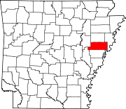
Colt is a Second Class City in St. Francis County, Arkansas, United States. The population was 378 at the 2010 census, an increase from 368 in 2000.[3] GeographyAccording to the United States Census Bureau, the city has a total area of 1.2 square miles (3.1 km2), all land. Demographics
At the 2000 census,[3] there were 368 people, 163 households and 111 families residing in the town. The population density was 295.2 inhabitants per square mile (114.0/km2). There were 188 housing units at an average density of 150.8 per square mile (58.2/km2). The racial makeup of the town was 94.02% White, 5.43% Black or African American, 0.54% from other races. 0.54% of the population were Hispanic or Latino of any race. There were 163 households, of which 27.6% had children under the age of 18 living with them, 55.8% were married couples living together, 7.4% had a female householder with no husband present, and 31.9% were non-families. 30.1% of all households were made up of individuals, and 13.5% had someone living alone who was 65 years of age or older. The average household size was 2.26 and the average family size was 2.77. Age distribution was 22.8% under the age of 18, 9.2% from 18 to 24, 29.3% from 25 to 44, 24.7% from 45 to 64, and 13.9% who were 65 years of age or older. The median age was 38 years. For every 100 females, there were 94.7 males. For every 100 females age 18 and over, there were 94.5 males. The median household income was $31,250, and the median family income was $37,000. Males had a median income of $31,000 versus $19,375 for females. The per capita income for the town was $14,958. About 11.7% of families and 13.7% of the population were below the poverty line, including 19.5% of those under age 18 and 15.9% of those age 65 or over. TransportationThe main Highways of Colt are Arkansas State Routes 1 and 306. The two routes cross each other in the middle of the town. The Delta Regional Airport serves as the city's primary airport. Rail Service is provided by the Union Pacific. EducationForrest City School District operates public schools serving the community.[5] Forrest City High School is the local high school. Notable people
References
Wikimedia Commons has media related to Colt, Arkansas. |
||||||||||||||||||||||||||||||||||||||||||||||||||||||||||||||||||||||||||||||||||||||||||||||


