|
Deeg
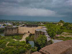
  Deeg is an ancient historical city in Deeg district of Rajasthan, India. It is carved out from its former district bharatpur on 7 August 2023. It is situated 32 kilometres (20 mi) north of Bharatpur and 98 kilometres (61 mi) northwest of Agra. In Hindu mythology, Deeg was situated along the parikrama path of Krishna, which started at Goverdhan, 14 kilometres (8.7 mi) from Deeg. Some people[who?] identify it as the ancient town of "Dirgha" or "Dirghapur" mentioned in the epic Skanda Purana. Deeg was the first capital of the Sinsinwar Hindu Jat state of Bharatpur, when Maharaja Badan Singh was proclaimed its ruler in 1722. In 1730, Maharaja Suraj Mal built the strong fortress of Deeg. After Suraj Mal moved the capital to Bharatpur, Deeg became the second capital of the rulers of Bharatpur princely state. It is known for its number of forts, palaces, gardens and fountains. Deeg in filmsSome scenes of Noorjehan (1967) were shot in Deeg Palace, as does Mughal-e-Azam. The same is true for Siddhartha (1972), an Indo-American drama mystery film based on the 1922 novel of the same name by Hermann Hesse. Siddhartha also has some scenes in Bharatpur's Keoladeo National Park. GeographyDeeg Palace is a Palace in Deeg & 32 km from city of Bharatpur in Deeg District in Rajasthan, India. It is built in 1772 as a luxurious summer resort for the rulers of Bharatpur State. The palace was in active use till the early 1970s.[1] Deeg Palace is the only palace of Hindu style in the whole of North India. Deeg is located at 27°28′N 77°20′E / 27.47°N 77.33°E.[2] It has an average elevation of 174 m (571 ft). HistoryAfter acquiring the throne, Maharaja Badan Singh chose Deeg as the place for his stronghold and capital. Hence, he initiated the construction of the Deeg Palace here. Being the capital of the Jat rulers and located at a distance of just about 32 km from Bharatpur, his palace served as a summer mansion for the royal family. He became the founder of Jat House in Bharatpur and under his reign, the place gained immense prosperity and urbanisation. In fact, Maharaja Surajmal, son of Badan Singh is often hailed as the hero of the Jat dynasty. Owing to its great location, architectural beauty and grandeur, the palace caught the attention of many dynasties and almost constantly under the threat from Mughals. Hence, in order to protect the stunning Deeg Palace against the attack from invader, Maharaja Suraj Mal ordered the construction of a mighty fortress around the palace. During 1804, both the Battle of Deeg and the Siege of Deeg brought the British East India Company into conflict with Bharatpur's Jat rulers and their Maratha allies for control of the area. ArchitectureThe palace complex together with its water gardens was a summer retreat for the maharajas of Bharatpur. The layout comprises several palaces called Bhawans, interwoven within series of charbaghs and water gardens. The major Bhawans are Gopal Bhawan, Divan I Khas or the Kishan Bhawan, Wrestling palace or Nand Bhawan, Keshav Bhawan, Hardev Bhawan, Suraj Bhawan and symmetrically arranged twin pavilions of Sawan & Bhadon.[3] "Deeg and Delhi were at that time the center of equal beauty and trade, Deeg was the first class among the protected places of fortifications of India." DemographicsAs of 2011[update] India census,[4] Deeg had a population of 44,999. Males constitute 54% of the population and females 46%. Deeg has an average literacy rate of 75.61%, higher than the national average of 74.04%: male literacy is 85.73% and, female literacy is 64.23%. In Deeg, 17% of the population is under 6 years of age. Sex ratio of Deeg is 886 Attractions and festivals
ReferencesWikimedia Commons has media related to Deeg.
|
||||||||||||||||||||||||||||||||||||||||||||||


