Khan Yunis (Arabic: خان يونس, lit. 'Caravansary [of] Yonis[2]'), also spelled Khan Younis or Khan Yunus, is a Palestinian city serving as the capital of the Khan Yunis Governorate in the southern Gaza Strip. It has been largely destroyed on account of the ongoing Israel–Hamas war.
Before the 14th century, Khan Yunis was a village known as "Salqah". To protect caravans, pilgrims and travellers a vast caravan serai was constructed there by the emir Yūnus an-Nūrūzī in 1387–88, an official of the Mamluk Empire.[3]
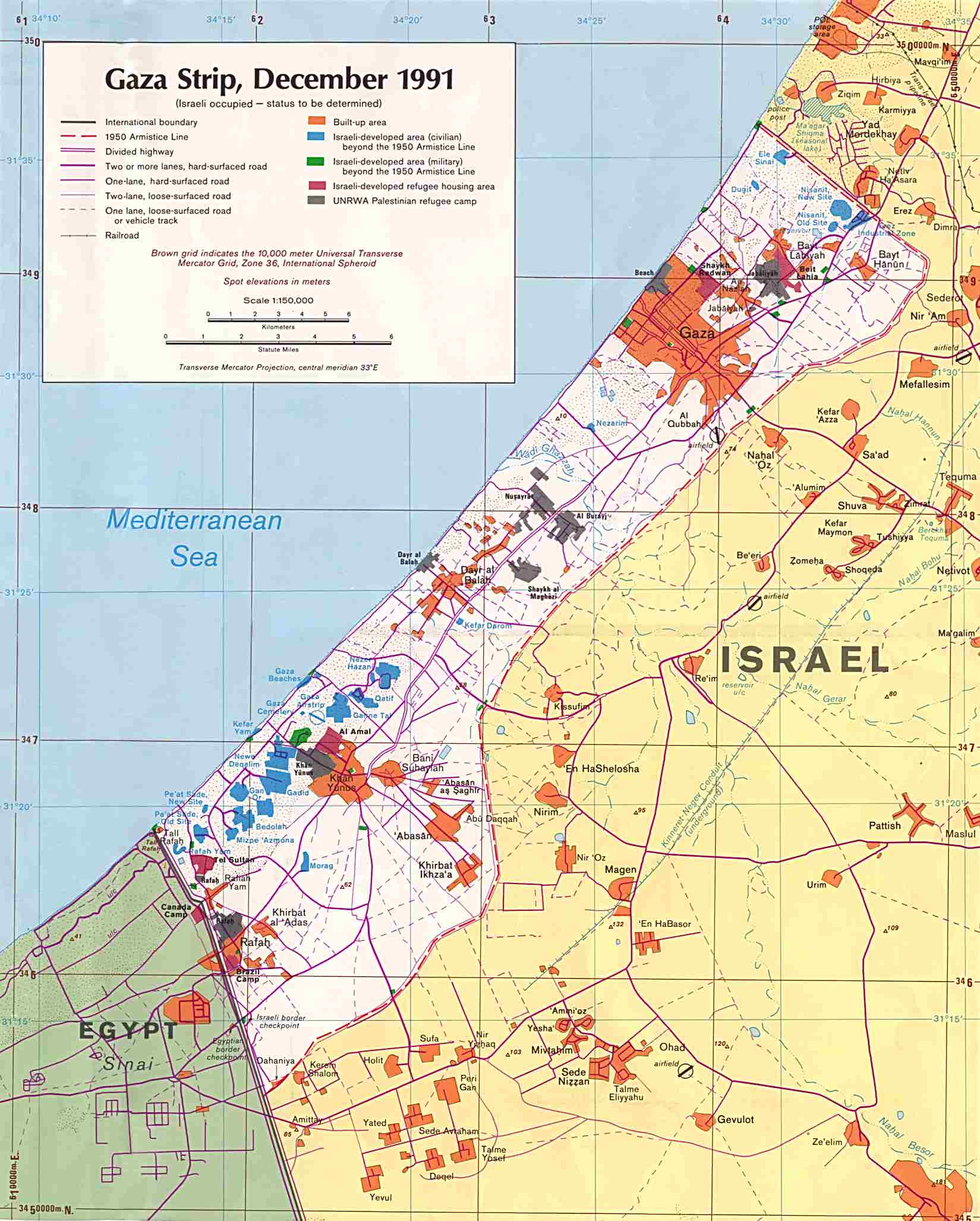
According to the Palestinian Central Bureau of Statistics, Khan Yunis had a population of 205,125 in 2017.[1] Khan Yunis, which lies only four kilometres (2+1⁄2 miles) east of the Mediterranean Sea, has a semi-arid climate with temperature of 30 °C maximum in summer and 10 °C minimum in winter, with an annual rainfall of approximately 260 mm (10.2 in).
History
The southern part of the historic khan at Khan Yunis, 1930s
Ancient period
Herodotus describes a city named Ienysos (Ancient Greek: Ιηνυσος) located between Lake Serbonis and Kadytis (modern Gaza city). He talks about how the Persian military marched through the location on its way to Egypt. He also describes how the coastal area between Kadytis and Ienysos was inhabited by local Arab tribes. Some sources, due to phonological resemblance of the names and due to the general matching of the geographic locations, associate this site with modern Khan Yunis.[4]
Other sources have suggested a further inland location of "Khirbet Ma'in Abu Sitta" (Palestinian village depopulated in 1949, near modern kibbutz of Nir Oz)[5] or the Egyptian town of Arish as possible locations of Ienysos, but there is no clear evidence to support this identification.[4][6]
Ancient discoveries in Khan Yunis feature a lintel with a Greek inscription, discovered repurposed in the tomb of Sheikh Hamada. The inscription translates to: 'Hilarion - giving thanks to St. Georgius.' Originally housed in the Musée de Notre Dame de France in Jerusalem, the lintel is currently lost.[7]
Establishment by Mamluks
Before the 14th century, Khan Yunis was a village known as "Salqah".[3] To protect caravans, pilgrims and travellers a vast caravan serai was constructed there by emir Yūnus an-Nūrūzī in 1387–88, an official of the Mamluk Empire.[3] The growing town surrounding it was named "Khan Yunis" after him. In 1389 Yunus was killed in battle.[8] Yunus ibn Abdallah an-Nuruzi ad-Dawadar was the executive secretary (dawadar), one of the high-ranking officials of the Mamluk sultan Barquq. The town became an important center for trade and its weekly Thursday market drew traders from neighboring regions.[9]
The khan served as resting stop for couriers of the barid, the Mamluk postal network in Palestine and Syria.
Ottoman period
In late 1516 Khan Yunis was the site of a minor battle in which the Egypt-based Mamluks were defeated by Ottoman forces under the leadership of Sinan Pasha. The Ottoman sultan Selim I then arrived in the area where he led the Ottoman army across the Sinai Peninsula to conquer Egypt.[10] During the 17th and 18th centuries the Ottomans assigned an Asappes garrison associated with the Cairo Citadel to guard the fortress at Khan Yunis.[11]
Pierre Jacotin named the village Kan Jounes on his map from 1799,[12] while in 1838, Robinson noted Khan Yunas as a Muslim village located in the Gaza district.[13] In 1863 French explorer Victor Guérin visited Khan Yunis. He found it had about a thousand inhabitants, and that many fruit trees, especially apricots were planted in the vicinity.[14]
At the end of the 19th-century the Ottomans established a municipal council to administer the affairs of Khan Yunis, which had become the second largest town in the Gaza District after Gaza itself.[15]
British Mandate
In the 1922 census of Palestine conducted by the British Mandate authorities, Khan Yunis had a population of 3890 inhabitants (3866 Muslims, 23 Christians, and one Jew),[16] decreasing in the 1931 census to 3811 (3767 Muslims, 41 Christians, and three Jews), in 717 houses in the urban area[17] and 3440 (3434 Muslims and 6 Christians) in 566 houses in the suburbs.[18]
Khan Yunis 1931 1:20,000
In the 1938 village statistics, the population is listed as 4,379 (including three Jews) with 3,953 in nearby suburbs.[19] In the 1945 statistics, Khan Yunis had a population of 11,220 (11,180 Muslims and 40 Christians),[20] with 2,302 (urban) and 53,820 (rural) dunams of land, according to an official land and population survey.[21] Of this, 4,172 dunams were plantations and irrigable land, 23,656 used for cereals,[22] while 1,847 dunams were built-up land.[23]
During the night of 31 August 1955, three Israeli paratroop companies attacked the British-built Tegart fort in Khan Yunis from where attacks had been carried out against Israelis.[24] The police station, a petrol station and several buildings in the village of Abasan were destroyed, as well as railway tracks and telegraph poles. In heavy fighting, 72 Egyptian soldiers were killed. One Israeli soldier was killed and 17 were wounded. The operation led to a ceasefire on September 4, forcing President Gamal Abdel Nasser and the Egyptian government to halt Palestinian fedayeen operations against Israel.[25] One of the mechanized companies was commanded by Rafael Eitan.[24][26]
Before the Suez War, Khan Yunis was officially administered by the All-Palestine Government, seated in Gaza and later in Cairo. After a fierce firefight, the Sherman tanks of the IDF 37th Armored Brigade broke through the heavily fortified lines outside of Khan Yunis held by the 86th Palestinian Brigade.[27] It was the only site in the Gaza strip where the Egyptian army put up any resistance to the Israeli invasion of Gaza, but it surrendered on 3 November 1956.
There are conflicting reports of what happened. Israel said that Palestinians were killed when Israeli forces were still facing armed resistance, while the Palestinians said all resistance had ceased by then, and that many unarmed civilians were killed as the Israel troops went through the town and camp, seeking men in possession of arms.[28][29]
The killings, dubbed the Khan Yunis massacre, were reported to the UN General Assembly on 15 December 1956 by the Director of the United Nations Relief and Works Agency, Henry Labouisse. According to the report, the exact number of dead and wounded is not known, but the director received lists of names of persons allegedly killed from a trustworthy source, including 275 people, of which 140 were refugees and 135 local residents.[29][30]
After 1959, the All-Palestine Government of Gaza Strip was abolished and the city was included in the United Arab Republic, which was shortly disestablished and the Gaza Strip came under the direct Egyptian military occupation rule.
As a result of the 1993-1995 Oslo Accords, Khan Yunis and most of the Gaza Strip (excluding Israeli settlements and military areas) were placed under the control of the Palestinian Authority.
Khan Yunis was the site of Israeli helicopter attacks in August 2001 and October 2002 that left several civilians killed, hundreds wounded and civilian buildings within the vicinity destroyed.[citation needed]
During the ongoing Israel–Hamas war, Israel has bombed Khan Yunis along with other cities in the Gaza Strip as part of an offensive against Hamas. The Israeli Air Force extensively bombed much of the city, including the Hamad City apartment complex.[31][32][33] Local sources have reported numerous civilian casualties in Khan Yunis as a result of Israeli bombings,[34][35] which Palestinian news agency Wafa put at "at least 70" as of December 3.[36] The Al Qarara Cultural Museum was destroyed in an explosion as a result of an Israeli attack in October 2023, part of an offensive that reportedly targeted civilian homes and mosques in the vicinity.[37][38] Israeli armored units began entering the outskirts of the city in December 2023. After several months of fighting, Israeli forces ended up withdrawing from Khan Yunis and most of the southern Gaza Strip.[39][40][41] Having failed to root out Hamas from Khan Yunis,[42][43] Israeli forces began a second invasion of the city in late July 2024, which also ended in an Israeli withdrawal.[44] Israeli forces invaded Khan Yunis yet again in August 2024, and withdrew once more at the end of the month.[45]
Economy
Khan Yunis is the second largest urban area in the Gaza Strip after Gaza City. It serves as the principal market center of the territory's southern half and hosts a weekly Bedouin souk ("open-air market") mostly involving local commodities.[46] As of 2012[update] Khan Yunis had the highest unemployment rate in the Palestinian territories.[47]
^ abRetsö, J. (2014). The Arabs in antiquity: Their history from the Assyrians to the Umayyads - "Chapter 9: The Age of the Achaemenids - Herodotus of Halicarnassus". Routledge.
^Abu-Sitta, S. H. (2017). Mapping my return: A Palestinian memoir. American University in Cairo Press.
^Verreth, Herbert (2006). The northern Sinai from the 7th century BC till the 7th century AD. A guide to the sources. Vol. 1. Leuven. p. 263.
^ abUNRWA Report to the UN General Assembly November 1 – December 14, 1956Archived June 29, 2013, at the Wayback Machine.: "The town of Khan Yunis and the Agency's camp adjacent thereto were occupied by Israel troops on the morning of 3 November. A large number of civilians were killed at that time, but there is some conflict in the accounts given as to the causes of the casualties. The Israel authorities state that there was resistance to their occupation and that the Palestinian refugees formed part of the resistance. On the other hand, the refugees state that all resistance had ceased at the time of the incident and that many unarmed civilians were killed as the Israel troops went through the town and camp, seeking men in possession of arms. The exact number of dead and wounded is not known, but the Director has received from sources he considers trustworthy lists of names of persons allegedly killed on 3 November, numbering 275 individuals, of whom 140 were refugees and 135 local residents of Khan Yunis."
Konstusio paru Konstusio paru, dikenal juga dengan memar paru adalah cedera pada jaringan paru-paru tanpa kerusakan struktural yang sebenarnya akibat kecelakaan atau tertimpa beban berat. Akibatnya, darah dan cairan lain menumpuk di dalam jaringan paru-paru. Kelebihan cairan menyebabkan penurunan permukaan pernapasan yang menyebabkan hipoksia. Patofisiologi kontusio paru meliputi perubahan ventilasi dan perfusi (proses deoksigenasi dan reoksigenasi darah di paru[1]), peningkatan pirau in…
CipadaDesaPeta Desa Cipada di Kec. CisaruaPeta lokasi Desa CipadaNegara IndonesiaProvinsiJawa BaratKabupatenBandung BaratKecamatanCisaruaKode pos40751[1]Kode Kemendagri32.17.03.2005 Luas... km²Jumlah penduduk... jiwaKepadatan... jiwa/km² Cipada adalah desa di Kecamatan Cisarua, Kabupaten Bandung Barat, Jawa Barat, Indonesia. Desa ini dahulu adalah bagian dari Desa Cipada, Cikalong Wetan, Bandung Barat ketika masa kolonial Belanda dan masa pemerintahan sesudah merdeka wilayah ini a…
بطولة أوروبا للألعاب المائية 1926 البطولة بطولة أوروبا للألعاب المائية رقم الموسم الأول التاريخ 18–22 أغسطس 1926 المكان بودابست، المجر الفائزون الأول ألمانيا الثاني السويد الثالث المجر 1927 تعديل مصدري - تعديل بطولة أوروبا للألعاب المائية 1926 هو الموسم �…
Events at the1993 World ChampionshipsTrack events100 mmenwomen200 mmenwomen400 mmenwomen800 mmenwomen1500 mmenwomen3000 mwomen5000 mmen10,000 mmenwomen100 m hurdleswomen110 m hurdlesmen400 m hurdlesmenwomen3000 msteeplechasemen4 × 100 m relaymenwomen4 × 400 m relaymenwomenRoad eventsMarathonmenwomen10 km walkwomen20 km walkmen50 km walkmenField eventsHigh jumpmenwomenPole vaultmenLong jumpmenwomenTriple jumpmenwomenShot putmenwomenDiscus throwmenwomenHammer throwmenJavelin throwmenwomenCombine…
Latvijas PSR čempionāts futbolā 1967A klase 1967 Competizione Virslīga Sport Calcio Edizione 23ª Organizzatore LFF Luogo Unione Sovietica RSS Lettone Partecipanti 14 Risultati Vincitore ESR Riga(2º titolo) Statistiche Incontri disputati 183 Gol segnati 426 (2,33 per incontro) Cronologia della competizione 1966 1968 Manuale L'edizione 1967 del massimo campionato di calcio lettone fu la 23ª come competizione della Repubblica Socialista Sovietica Lettone; il titolo fu v…
Henri IIIPotret oleh François ClouetRaja PolandiaAdipati Agung LituaniaBerkuasa16 Mei 1573 – 12 Mei 1575Penobatan22 Februari 1574, Katedral WawelPendahuluZygmunt II AugustPenerusAnna and IstvánInterrexJakub UchańskiRaja PrancisBerkuasa30 Mei 1574 – 2 Agustus 1589Penobatan13 Februari 1575, Katedral ReimsPendahuluCharles IXPenerusHenri IVInformasi pribadiKelahiran(1551-09-19)19 September 1551Château de FontainebleauKematian2 Agustus 1589(1589-08-02) (umur 37)Château de Saint-CloudPem…
United States historic placeOskaloosa City HallU.S. National Register of Historic PlacesU.S. Historic districtContributing property Show map of IowaShow map of the United StatesLocationJct. of S. Market St. and 2nd Ave. E., NE cornerOskaloosa, IowaCoordinates41°17′37″N 92°38′40″W / 41.29361°N 92.64444°W / 41.29361; -92.64444Arealess than one acreBuilt1911ArchitectFrank E. WetherellS.B. SinclairArchitectural styleRenaissance RevivalPart ofOskaloosa City Sq…
Major League Baseball team season 2000 Cincinnati RedsLeagueNational LeagueDivisionCentralBallparkCinergy FieldCityCincinnatiRecord85–77 (.525)Divisional place2ndOwnersCarl LindnerGeneral managersJim BowdenManagersJack McKeonTelevisionFSN Ohio (George Grande, Chris Welsh)RadioWLW(Marty Brennaman, Joe Nuxhall)StatsESPN.comBB-reference ← 1999 Seasons 2001 → The Reds playing against the Milwaukee Brewers during an August 2000 away game at Milwaukee County Stadium. The 2…
Questa voce o sezione sull'argomento veicoli militari non cita le fonti necessarie o quelle presenti sono insufficienti. Puoi migliorare questa voce aggiungendo citazioni da fonti attendibili secondo le linee guida sull'uso delle fonti. Segui i suggerimenti del progetto di riferimento. MT-LBMT-LBDescrizioneEquipaggio2+11 fanti Dimensioni e pesoLunghezza7,47 m Larghezza2,85 m Altezza2,42 m Peso14,9 t Propulsione e tecnicaMotoreYaMZ-238N diesel V8 Potenza220 hp Trazionecingolata PrestazioniVe…
Script used to write the Aramaic language Aramaic alphabetAramaic inscription from Tayma, containing a dedicatory inscription to the god SalmScript type Abjad Time period800 BC to AD 600DirectionRight-to-leftLanguagesAramaic (Syriac[1] and Mandaic), Hebrew, EdomiteRelated scriptsParent systemsEgyptian hieroglyphsProto-SinaiticPhoenicianAramaic alphabetChild systems Hebrew[1] Maalouli[2][3] Nabataean[1] Arabic Syriac Sogdian Old Uyghur Mongolian Manchu Chri…
Historic movie theater in Tuscaloosa, Alabama Not to be confused with Alabama Theatre. United States historic placeBama Theatre-City Hall BuildingU.S. National Register of Historic PlacesAlabama Register of Landmarks and Heritage The theatre in 2010Show map of AlabamaShow map of the United StatesLocation600 Greensboro Ave, Tuscaloosa, AlabamaCoordinates33°12′31″N 87°34′5″W / 33.20861°N 87.56806°W / 33.20861; -87.56806Built1937ArchitectDavid O. Whilldin of Birm…
MedusaMedusa, disegni di Stjepan Šejić UniversoUniverso Marvel Lingua orig.Inglese AutoriStan Lee Jack Kirby EditoreMarvel Comics 1ª app.marzo 1965 1ª app. inThe Fantastic Four (vol. 1[1]) n. 36 Editore it.Editoriale Corno 1ª app. it.maggio 1972 1ª app. it. inI Fantastici Quattro n. 31 Interpretata daSerinda Swan Voce italianaFederica De Bortoli Caratteristiche immaginarieAlter egoMedusalith Amaquelin-Boltagon Specieinumana SessoFemmina Etniaattilana Luogo di n…
Men's national volleyball team representing Brazil BrazilNickname(s)CanarinhosGalacticBest of All TimesAssociationCBVConfederationCSVHead coachBernardo Rezende[1]FIVB ranking5 (as of 2 December 2023)Uniforms Home Away Third Summer OlympicsAppearances14 (First in 1964)Best result (1992, 2004, 2016)World ChampionshipAppearances17 (First in 1956)Best result (2002, 2006, 2010)World CupAppearances12 (First in 1969)Best result (2003, 2007, 2019)www.cbv.com.br (in Portuguese) Honours Event 1st …
President of Nicaragua from 1909 to 1910 In this Spanish name, the first or paternal surname is Madriz and the second or maternal family name is Rodríguez. José Madriz RodríguezPresident of NicaraguaActingIn office21 December 1909 – 20 August 1910Preceded byJosé Santos ZelayaSucceeded byJosé Dolores Estrada (Acting) Personal detailsBornJosé Santos Madriz Rodríguez(1867-07-21)21 July 1867León, NicaraguaDied14 May 1911(1911-05-14) (aged 43)Mexico City, MexicoPolitic…
County in New Mexico, United States County in New MexicoUnion CountyCountyUnion County Courthouse in ClaytonLocation within the U.S. state of New MexicoNew Mexico's location within the U.S.Coordinates: 36°29′N 103°28′W / 36.48°N 103.47°W / 36.48; -103.47Country United StatesState New MexicoFoundedJanuary 1, 1894SeatClaytonLargest townClaytonArea • Total3,831 sq mi (9,920 km2) • Land3,824 sq mi (9,900 …
Esta página cita fontes, mas que não cobrem todo o conteúdo. Ajude a inserir referências. Conteúdo não verificável pode ser removido.—Encontre fontes: ABW • CAPES • Google (N • L • A) (Junho de 2022) IV Campeonato Brasileiro de Futebol Taça Brasil de 1961 Dados Participantes 18 Organização CBD Local de disputa Brasil Período 9 de julho – 27 de dezembro Gol(o)s 124 Partidas 38 Média 3,26 gol(o)s por partida Campeão S…
Эта статья включает описание термина «энергия покоя» Эта статья включает описание термина «E=mc2»; см. также другие значения. Эквивале́нтность ма́ссы и эне́ргии — физическая концепция теории относительности, согласно которой полная энергия физического объекта (физичес…


")


