Share to: share facebook share twitter share wa share telegram print page

Lyceum–The Circle Historic District

Lyceum–The Circle Historic District
Lyceum Building
Lyceum–The Circle Historic District is located in Mississippi
Lyceum–The Circle Historic District
LocationUniversity Circle, Oxford, Mississippi
Coordinates34°21′57.6″N 89°32′5.7″W / 34.366000°N 89.534917°W / 34.366000; -89.534917
Area10 acres (40,000 m2)
Built1848
ArchitectWilliam Nichols
Architectural styleNeoclassical Revival
NRHP reference No.08001092
Significant dates
Added to NRHPOctober 7, 2008[1]
Designated NHLDOctober 7, 2008[1]

The Lyceum–The Circle Historic District is a historic district within the University of Mississippi campus in Oxford, Mississippi. It includes eight buildings and several monuments lining University Circle, and surrounds "The Circle" on the campus. The university was established as the flagship public institution of the state, and generations of leading families' sons and daughters have studied here.

The district is also significant for its association with the civil rights movement during the Ole Miss riot of 1962 and the increasing role the Federal government took to preserve constitutional rights of minorities. Ole Miss was integrated by the enrollment of James H. Meredith, an African-American military veteran, on October 1, 1962. In Mississippi in the fall of 1962, there was violent resistance to court-ordered desegregation of the university. The violence required intervention by the Federal government to protect the safety of citizens.

Meredith's admission was followed by riots on the campus, by both white students and outside segregationists who gathered there from around the state. The disturbances took place following court decisions for integration of public educational institutions, during the civil rights movement. This historic district was designated as a U.S. National Historic Landmark on October 7, 2008. (This may not have been announced publicly until October 14.)[1][2]

Elements of the district

Located at the center of the University of Mississippi campus, the district contains eight academic buildings arranged on University Circle, which encompasses an interior common area dubbed "The Circle," a historic site in the district. The eight buildings include the Lyceum Building, Brevard Hall, the Croft Institute for International Studies (known as the "Y" Building at the time of desegregation and earlier as the "Old Chapel"), and Carrier, Shoemaker, Ventress, Bryant, and Peabody dormitory halls. The district also includes the flagpole in the center of The Circle, the Confederate Monument in The Circle, and University Circle.[2]

Lyceum Building
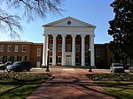
34°21′56″N 89°32′10″W / 34.365494°N 89.536037°W / 34.365494; -89.536037 (Lyceum Building)

In the university's early days, the Lyceum Building was the only academic structure, housing a lecture hall, several classrooms, the faculty offices, a geological museum, and the library.[3] The Lyceum is now used for the university's administration offices. Its columned facade is represented on the official crest of the university, along with the date of establishment. Built in 1848 to the designs of architect William Nichols, the building is the oldest on campus and concurrent with its founding.[2]

The Circle

34°21′55″N 89°32′06″W / 34.36533°N 89.53498°W / 34.36533; -89.53498 (The Circle)

The Circle is surrounded by University Circle, a road designed for one-way traffic. The area contains oak and magnolia trees, beds of pansies, and expanses of grass. A metal flagpole stands at the center of the green, serving as a hub for the sidewalk paths through the area. Since the mid-nineteenth century, The Circle has been the focal point and historic core of the Ole Miss campus.[2]

Flagpole
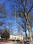
34°21′55″N 89°32′06″W / 34.365311°N 89.535051°W / 34.365311; -89.535051 (Flagpole)

The flagpole has stood in the center of The Circle since 1962. Its brick base was constructed in 2000. During the famous desegregation riots, a former Ole Miss football player climbed the pole in an effort to attract rioters' attention and convince them to go home.[2]

Confederate Monument

34°21′55″N 89°32′03″W / 34.365284°N 89.534085°W / 34.365284; -89.534085 (Confederate Monument)

A contextual plaque now stands in the same position where the Confederate Monument stood from 1906 until it was moved on July 14, 2020. The Confederate Monument was moved to the site of a Civil War cemetery in a secluded area of campus. 34°21′39″N 89°32′22″W / 34.3609677°N 89.539401°W / 34.3609677; -89.539401 (Confederate Monument)

The Confederate Monument contains a sub-column fashioned in the likeness of a castle, inscribed with the following: "To Our Confederate Dead, 1861-1865, Albert Sidney Johnston Chapter 379 U.D.C." (United Daughters of the Confederacy) and a Confederate soldier looking into the distance and holding a rifle at his side. It is often jokingly referred to by the Ole Miss and Oxford communities as the "second place trophy."[2]

University Circle

34°21′55″N 89°32′02″W / 34.365222°N 89.533962°W / 34.365222; -89.533962 (University Circle)

University Circle is a 50 ft (15 m) wide roundabout with outlets between the "Y" Building and Bryant Hall, and on either side of the Lyceum, providing access to other parts of the campus.[2]

Brevard Hall

34°21′53″N 89°32′09″W / 34.364677°N 89.535968°W / 34.364677; -89.535968 (Old Chemistry Building)

The Old Chemistry Building, now designated as Brevard Hall, was built in 1923. During the desegregation riots on September 30, 1962, students broke into the building and threw Molotov cocktail bombs from its windows at federal and civilian vehicles parked around The Circle.[2]

Carrier Hall

34°21′51″N 89°32′07″W / 34.364226°N 89.535222°W / 34.364226; -89.535222 (Carrier Hall)

Carrier Hall was one of several buildings which students plundered for riot material in 1962. Branching off from the two-story main section is a rear section connected by two covered passageways. This section also contains two stories and is slightly inset and setback from the main section.[2]

Shoemaker Hall

34°21′53″N 89°32′00″W / 34.364677°N 89.533431°W / 34.364677; -89.533431 (Shoemaker Hall)

During the 1962 riots, four-story Shoemaker Hall was under construction. Students took up construction materials, including loose bricks, metal conduit pipes, and a bulldozer to attack federal officers. The dorm hall was the site of one of the two fatalities associated with the riots. Each of the men killed was shot execution style.[2]

Ventress Hall

34°21′56″N 89°32′01″W / 34.365417°N 89.533672°W / 34.365417; -89.533672 (Ventress Hall)

Two-story Ventress Hall, built in 1889, appears in a famous photo of James Meredith walking in the commencement procession on August 18, 1963.[2]

"Y" Building

34°21′57″N 89°32′03″W / 34.365842°N 89.534305°W / 34.365842; -89.534305 (Croft Institute)

The Croft Institute for International Studies, known as the "Y" Building at the time of desegregation and earlier as the Old Chapel, in 1962 harbored many people escaping the tear gas and the general melee. Others crowded into the Y to watch United States President John F. Kennedy's televised speech regarding the desegregation of Ole Miss.[2]

Bryant Hall

34°21′58″N 89°32′06″W / 34.366236°N 89.534949°W / 34.366236; -89.534949 (Bryant Hall)

After housing the university's library from 1911 to 1952, Bryant Hall has been home to the Fine Arts Center and the departments of Philosophy, Religion, and Classics. During the riots, much of the pitched battle was fought in front of the hall.[2]

Peabody Hall

34°21′58″N 89°32′09″W / 34.366174°N 89.535780°W / 34.366174; -89.535780 (Peabody Hall)

During the riot, Peabody Hall offered people a safe harbor from tear gas. While trapped in the building, faculty member Russell Barrett documented the riot.[2]

References

  1. ^ a b c "Interior Designates 16 New National Historic Landmarks". D.O.I. News Release. U.S. Department of the Interior. October 14, 2008. Archived from the original on October 20, 2008. Retrieved October 16, 2008.
  2. ^ a b c d e f g h i j k l m n Gene Ford and Susan Cianci Salvatore (January 23, 2007). "National Historic Landmark Nomination: Lyceum" (PDF). National Park Service. {{cite journal}}: Cite journal requires |journal= (help)
  3. ^ "Virtual Tours - University of Mississippi". University of Mississippi. Retrieved July 11, 2008.

Read other articles:

Kay Ivey Gubernur Alabama ke-54PetahanaMulai menjabat 10 April 2017WakilWill Ainsworth PendahuluRobert BentleyPenggantiPetahanaWakil Gubernur Alabama ke-30Masa jabatan17 Januari 2011 – 10 April 2017GubernurRobert Bentley PendahuluJim Folsom Jr.PenggantiWill AinsworthBandahara Alabama ke-38Masa jabatan20 Januari 2003 – 17 Januari 2011GubernurBob Riley PendahuluLucy BaxleyPenggantiYoung Boozer Informasi pribadiLahirKay Ellen Ivey15 Oktober 1944 (umur 79)Camden, Alaba…

Il miglio verdeDavid Morse, Michael Clarke Duncan e Tom Hanks in una scena del filmTitolo originaleThe Green Mile Paese di produzioneStati Uniti d'America Anno1999 Durata189 min Generedrammatico, fantastico RegiaFrank Darabont SoggettoStephen King (romanzo) SceneggiaturaFrank Darabont ProduttoreFrank Darabont, David Valdes Casa di produzioneWarner Bros., Universal Pictures, Castle Rock Entertainment, Darkwoods Productions Distribuzione in italianoUIP FotografiaDavid Tattersall MontaggioRicha…

Lara Dutta BhupathiLara Dutta pada tahun 2012Lahir16 April 1978 (umur 46)Ghaziabad, Uttar Pradesh, IndiaPekerjaanAktris, Produser, ModelTahun aktif1995–sekarangSuami/istriMahesh Bhupathi (2011–sekarang)Anak1Situs webmylaradutta.com Lara Dutta Bhupathi (lahir 16 April 1978) adalah artis India, Dutabesar UNFPA dan Miss Universe tahun 2000. dan pada tahun yang sama wakil India lain di kontes yang lain pula juga memenangkan kontes serupa, yaitu Priyanka Chopra yang dinobatkan menjadi M…

Cinta Fitri Season 5Genre Drama Roman Keluarga PembuatMD EntertainmentDitulis olehLintang WardhaniSkenarioLintang WardhaniSutradaraEncep MasdukiPemeran Teuku Wisnu Shireen Sungkar Adly Fairuz Dinda Kanya Dewi Shandy Syarif Verlita Evelyn Iqbal Pakula Donita Nuri Maulida Lian Firman Penggubah lagu tema Melly Goeslaw Heru Lagu pembuka Atas Nama Cinta oleh Rossa [a] Cinta Kita oleh Shireen Sungkar feat. Teuku Wisnu [b] Lagu penutup Atas Nama Cinta oleh Rossa [c] Cinta Kita o…

ロバート・デ・ニーロRobert De Niro 2011年のデ・ニーロ生年月日 (1943-08-17) 1943年8月17日(80歳)出生地 アメリカ合衆国・ニューヨーク州ニューヨーク市身長 177 cm職業 俳優、映画監督、映画プロデューサージャンル 映画、テレビドラマ活動期間 1963年 -配偶者 ダイアン・アボット(1976年 - 1988年)グレイス・ハイタワー(1997年 - )主な作品 『ミーン・ストリート』(1973年)『…

International song competition Eurovision Song Contest 1983DatesFinal23 April 1983HostVenueRudi-Sedlmayer-HalleMunich, West GermanyPresenter(s)Marlene CharellMusical directorDieter ReithDirected byRainer BertramExecutive supervisorFrank NaefExecutive producerChristian HayerGünther LebramHost broadcasterArbeitsgemeinschaft der öffentlich-rechtlichen Rundfunkanstalten der Bundesrepublik Deutschland (ARD)Bayerischer Rundfunk (BR)Websiteeurovision.tv/event/munich-1983 ParticipantsNumber of entries…

Australian meat pie and soup dish Pie floaterTypeStreet foodPlace of originSouth AustraliaMain ingredientsAustralian meat pie, pea soup The pie floater is an Australian dish sold in Adelaide. It consists of a meat pie in a thick pea soup, typically with the addition of tomato sauce. Believed to have been first created in the 1890s, the pie floater gained popularity as a meal sold by South Australian pie carts. In 2003, it was recognised as a South Australian Heritage Icon. Development Pea soup w…

Aéroport international de Pékin-Capitale北京首都国际机场Běijīng Shǒudū Guójì Jīchǎng Vue aérienne de l'aéroport international de Pékin-Capitale Localisation Pays Chine Ville Pékin Coordonnées 40° 04′ 49″ nord, 116° 35′ 04″ est Altitude 35 m (116 ft) Informations aéronautiques Code IATA PEK Code OACI ZBAA Type d'aéroport public Gestionnaire Beijing Capital International Airport Company Limited Pistes Direction Longueur Surface 18L/3…

RoccapiemonteKomuneComune di RoccapiemonteLokasi Roccapiemonte di Provinsi SalernoNegaraItaliaWilayah CampaniaProvinsiSalerno (SA)Luas[1] • Total5,31 km2 (2,05 sq mi)Ketinggian[2]86 m (282 ft)Populasi (2016)[3] • Total9.124 • Kepadatan1,700/km2 (4,500/sq mi)Zona waktuUTC+1 (CET) • Musim panas (DST)UTC+2 (CEST)Kode pos84086Kode area telepon081Situs webhttp://www.comune.roccapiemonte.sa.it Ro…

American cardiologist and author (1910–1980) Herman TarnowerBorn(1910-03-18)March 18, 1910New York City, U.S.DiedMarch 10, 1980(1980-03-10) (aged 69)Purchase, New York, U.S.Cause of deathGunshot woundsEducationSyracuse UniversityOccupation(s)Cardiologist, writerNotable workThe Complete Scarsdale Medical Diet Herman Tarnower (March 18, 1910 – March 10, 1980) was an American cardiologist and co-author (with Samm Sinclair Baker) of the bestselling diet book The Complete Scarsdale …

County in Georgia, United States County in GeorgiaStewart CountyCountyStewart County courthouse in LumpkinLocation within the U.S. state of GeorgiaGeorgia's location within the U.S.Coordinates: 32°05′N 84°50′W / 32.08°N 84.84°W / 32.08; -84.84Country United StatesState GeorgiaFoundedDecember 23, 1830; 194 years ago (1830)Named forDaniel StewartSeatLumpkinLargest cityRichlandArea • Total464 sq mi (1,200 km2)…

 烏克蘭總理Прем'єр-міністр України烏克蘭國徽現任杰尼斯·什米加尔自2020年3月4日任命者烏克蘭總統任期總統任命首任維托爾德·福金设立1991年11月后继职位無网站www.kmu.gov.ua/control/en/(英文) 乌克兰 乌克兰政府与政治系列条目 宪法 政府 总统 弗拉基米尔·泽连斯基 總統辦公室 国家安全与国防事务委员会 总统代表(英语:Representatives of the President of Ukraine) 总理…

此条目序言章节没有充分总结全文内容要点。 (2019年3月21日)请考虑扩充序言,清晰概述条目所有重點。请在条目的讨论页讨论此问题。 哈萨克斯坦總統哈薩克總統旗現任Қасым-Жомарт Кемелұлы Тоқаев卡瑟姆若马尔特·托卡耶夫自2019年3月20日在任任期7年首任努尔苏丹·纳扎尔巴耶夫设立1990年4月24日(哈薩克蘇維埃社會主義共和國總統) 哈萨克斯坦 哈萨克斯坦政府與…

Jon Dahl Tomasson Informasi pribadiNama lengkap Jon Dahl TomassonTanggal lahir 29 Agustus 1976 (umur 47)Tempat lahir Roskilde, DenmarkTinggi 1,82 m (5 ft 11+1⁄2 in)Posisi bermain PenyerangInformasi klubKlub saat ini FeyenoordNomor 11Karier junior1981–19851985–1992 Solrød BKKøge BKKarier senior*Tahun Tim Tampil (Gol) 1992–19941994–19971997–19981998–20022002–20052005–20072007–20082008– Køge BKSC HeerenveenNewcastle UnitedFeyenoordMilanStuttgartVilla…

愛媛県立宇和高等学校三瓶分校 北緯33度22分35秒 東経132度25分31秒 / 北緯33.37639度 東経132.42528度 / 33.37639; 132.42528座標: 北緯33度22分35秒 東経132度25分31秒 / 北緯33.37639度 東経132.42528度 / 33.37639; 132.42528過去の名称 第二山下実科高等女学校第二山下高等女学校愛媛県立三瓶高等学校国公私立の別 公立学校設置者  愛媛県学区 南予学区学区外…

Hill in Germany Not to be confused with Drachenfels Castle (Wasgau). Drachenfels, view from Mehlem The Drachenfels (Dragon's Rock, German pronunciation: [ˈdʁaxənˌfɛls]) is a hill (321 metres (1,053 ft)) in the Siebengebirge uplands between Königswinter and Bad Honnef in Germany. The hill was formed by rising magma that could not break through to the surface, and then cooled and became solid underneath. It is the subject of much tourism and romanticism in the North Rhine-Westph…

Part of a series on theAnthropology of art,media, music, dance and film Basic concepts Color symbolism Visual culture Body culture Material culture New media Case studies Art Art of the Americas Indigenous Australian art Oceanic art Film Nanook of the North The Ax Fight Nǃai, the Story of a ǃKung Woman Incidents of Travel in Chichen Itza The Doon School Quintet Museums National Anthropological Archives Centro Cultural Mexiquense Museum of Anthropology at UBC Museum of Anthropology, Cambridge M…

Questa voce o sezione sull'argomento storia è priva o carente di note e riferimenti bibliografici puntuali. Sebbene vi siano una bibliografia e/o dei collegamenti esterni, manca la contestualizzazione delle fonti con note a piè di pagina o altri riferimenti precisi che indichino puntualmente la provenienza delle informazioni. Puoi migliorare questa voce citando le fonti più precisamente. Segui i suggerimenti del progetto di riferimento. Antica GreciaIl mondo greco intorno al 350 a.C., do…

Voce principale: Regno di Sardegna. Mappa della costa della Sardegna con le torri ancora esistenti e quelle in costruzione o in progettazione nel 1720, dalla biblioteca dell'Università di Cagliari Il Regno di Sardegna, come possedimento dell'impero spagnolo, fu conteso tra due dinastie, gli Asburgo e i Borboni dal 1700 al 1720. Con la morte di Carlo II, l'ultimo degli Asburgo spagnoli, il 1º novembre 1700, il trono passò al duca Filippo d'Angiò (Filippo V di Spagna), sebbene anche l'imperato…

Russian admiral (1844–1915) Aleksei Alekseyevich BirelevAlexei Birilev as Kontr Admiral (Rear Admiral)Born(1844-03-16)March 16, 1844near Tver, Russian EmpireDiedFebruary 16, 1915(1915-02-16) (aged 70)Petrograd, Russian EmpireAllegiance Russian EmpireService/branch Imperial Russian NavyYears of service1859–1907RankAdmiralCommands heldBaltic FleetRussian Pacific FleetBattles/warsRusso-Japanese WarOther workNavy Minister Aleksei Alekseyevich Birelev (Russian: Алекс…

Kembali kehalaman sebelumnya