Share to: share facebook share twitter share wa share telegram print page

Moundville Archaeological Site

Moundville Archaeological Site
Artist's conception of the Moundville Archaeological Site
Moundville Archaeological Site is located in Alabama
Moundville Archaeological Site
Moundville Archaeological Site is located in the United States
Moundville Archaeological Site
Location634 Mound State Parkway
Moundville, Alabama, US
Nearest cityTuscaloosa
Coordinates33°00′17″N 87°37′52″W / 33.00467°N 87.63107°W / 33.00467; -87.63107
NRHP reference No.66000149
Significant dates
Added to NRHPOctober 15, 1966[1]
Designated NHLJuly 19, 1964 [2]

Moundville Archaeological Site, also known as the Moundville Archaeological Park, is a Mississippian culture archaeological site on the Black Warrior River in Hale County, near the modern city of Tuscaloosa, Alabama.[3] Extensive archaeological investigation has shown that the site was the political and ceremonial center of a regionally organized Mississippian culture chiefdom polity between the 11th and 16th centuries. The archaeological park portion of the site is administered by the University of Alabama Museums and encompasses 185 acres (75 ha), consisting of 29 platform mounds around a rectangular plaza.[3]

The site was declared a National Historic Landmark in 1964 and was added to the National Register of Historic Places in 1966.[2]

Moundville is the second-largest site in the United States of the classic Middle Mississippian era, after Cahokia in Illinois. The culture was expressed in villages and chiefdoms throughout the central Mississippi River Valley, the lower Ohio River Valley, and most of the Mid-South area, including Kentucky, Tennessee, Alabama, and Mississippi as the core of the classic Mississippian culture area.[4] The park contains a museum and an archaeological laboratory.

History

Moundville was mentioned by E. G. Squier and Edwin Hamilton Davis in their work, Ancient Monuments of the Mississippi Valley (c1848), a survey conducted for the Smithsonian Institution. Later in the century, Nathaniel Thomas Lupton created a fairly accurate map of the site.

Little excavation work was conducted at Moundville by the Bureau of Ethnology's Division of Mound Exploration, partly because the landowner imposed a fee. The first significant archaeological investigations were not conducted until the early 20th century, by Clarence Bloomfield Moore, a lawyer from Philadelphia. He dug extensively at Moundville in 1906, and his detailed records of his work and finds have been of use to modern archaeologists. But looters dug into the mounds over the next two decades and took many artifacts, in addition to destroying stratigraphy of some structures.

In the mid-1920s concerned citizens, including Walter B. Jones (geologist) (after whom the site's museum is named) had begun a concerted effort to save the site. With the help of the Alabama Museum of Natural History, they purchased the land containing the mounds. By 1933 the site had officially become known as Mound State Park, but the park was not developed for visitors until 1938. During this period of the Great Depression, workers of the Civilian Conservation Corps were brought in to stabilize the mounds against erosion. They also constructed roads and buildings to allow public uses at the site. The name of the park was changed to Mound State Monument and was opened to the public in 1939.

During a 1980 break-in at the Erskine Ramsay Archaeological Repository at Moundville, 264 pottery vessels, one-fifth of the vessel collection curated by the Alabama Museum of Natural History, were stolen. The highest-quality specimens were taken. Despite an investigation by the Federal Bureau of Investigation, none of the artifacts was seen again until 2018 when three ceremonial bowls were anonymously returned.[5]

In 1991, the park's name was officially changed to Moundville Archaeological Park. In November 2021, the Native American Graves Protection and Repatriation Review Committee found the site to be culturally linked to the seven Muskogean-speaking tribes who have petitioned for the return of 5,982 human remains and funerary objects.[6]

Site
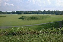
A view of the site from the top of Mound B looking toward Mound A and the plaza
A view across the plaza from mound J to mound B, with mound A in the center

The site was occupied by Native Americans of the Mississippian culture from around 1000 AD to 1450 AD.[3] Around 1150 AD the settlement's leaders began their rise from a local to a regional center, known as a chiefdom. At its height, the community took the form of a roughly 300-acre (121 ha) residential and political area, protected on three sides by a bastioned wooden palisade wall. The remaining side was protected by the river bluff.[3]

The largest platform mounds were built on the northern edge of the plaza; they become increasingly smaller going either clockwise or counter clockwise around the plaza to the south. Scholars theorize that the highest-ranking clans occupied the large northern mounds, with the smaller mounds' supporting buildings used for residences, mortuary, and other purposes. A total of 29 mounds remain on the site.[3]

Of the two largest mounds in the group, Mound A occupies a central position in the great plaza, and Mound B lies just to the north. It is a steep, 58 feet (18 m)-tall pyramidal mound with two access ramps.[3] Archaeologists have also found evidence at the site of borrow pits, other public buildings, and a dozen small houses constructed of pole and thatch.

Archaeologists have interpreted this community plan as a sociogram, an architectural depiction of a social order based on ranked clans. According to this model, the Moundville community was segmented into a variety of different clan precincts, the ranked positions of which were represented in the size and arrangement of paired earthen mounds around the central plaza. By 1300, the site was being used more as a religious and political center than as a residential town.[3] This signaled the beginning of a decline, and by 1500 most of the area was abandoned.[3]

Population
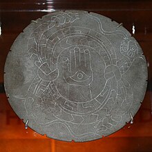
Engraved stone palette from Moundville, illustrating two horned rattlesnakes, perhaps referring to The Great Serpent of the Southeastern Ceremonial Complex

The surrounding area appears to have been densely populated, but the people built relatively few mounds before AD 1200, after which the public architecture of the plaza and mounds was constructed.[3] At its height, the population is estimated to have been around 1,000 to 3,000 people within the walls, with 10,000 additional people in the surrounding river valley.[3]

Based on findings during excavations, the residents of the site were skilled in agriculture, especially the cultivation of maize. Production of maize surpluses gave the people time produce to trade for other goods, supported population density, and allowed craft specialization.[3] Extensive amounts of imported luxury goods, such as copper, mica, galena, and marine shell, have been excavated from the site.[3] The site is renowned by scholars for the artistic excellence of its artifacts of pottery, stonework, and embossed copper left by the former residents.[3]

Excavations and interpretation

Feline statuette excavated at the Moundville site

The first major excavations were done in 1905-06 by Clarence Bloomfield Moore, an independent archeologist, before archaeology had become a professional field of scholarship. His work first brought the site national attention and contributed to archaeologists developing the concept of the Southeastern Ceremonial Complex.[7] One of his many discoveries was a finely carved diorite bowl depicting a crested wood duck. He later donated this work to the Smithsonian Institution, together with more than 500 other pieces.[7]

Although the state had shown little interest in the site, after Moore removed this and many of the site's finest artifacts, the Alabama Legislature passed a law prohibiting people from taking any other artifacts from the state. Archaeological techniques in general were relatively crude when compared to modern standards, but some professionals even during his time criticized Moore for his excavation techniques.[7]

The first large-scale scientific excavations of the site began in 1929 by Walter B. Jones, director of the Alabama Museum of Natural History, and the archaeologist David L. DeJarnette.[8] During the 1930s, Jones used some workers from the Civilian Conservation Corps for excavation as well as stabilization of the mounds. This was a work program developed by the President Franklin D. Roosevelt administration during the Great Depression.

In the early 21st century, work is led by Dr. Jim Knight, Curator of Southeastern Archaeology at the University of Alabama. He is conducting field research at Moundville with an emphasis on ethnohistorical reconstruction. A ceremonial "earth lodge" was discovered in 2007, and about 15 percent of the site has been excavated.[9]

The Jones Archaeological Museum was constructed on the park property in 1939 for display of artifacts collected at the site and interpretation of the ancient peoples and culture. It served as a valuable teaching center for many decades. In the 21st century, the museum was remodeled and equipped with the latest technological improvements in 2010. The University of Alabama maintains an archaeological lab at the park and sponsors summer field seasons and public events.

Ceramics
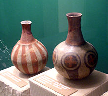
Mississippian culture pottery found at the Moundville site

Two major varieties of pottery are associated with the Moundville site. The Hemphill style pottery is a locally produced ware with a distinctive engraving tradition, and is mostly associated with burial practices.[10] The other variety consists of painted vessels, many of which were not produced locally, which is evidence of trade taking place among other societies outside of the one that lived in Moundville. Unlike the engraved pottery, the negative-painted pottery seems to have been used only by the elites at the Moundville site, as it has not been found outside the site.[11]

Moundville Archaeological Site Human Remains Controversy

In accordance with the 1990 Native American Graves Protection and Repatriation Act (NAGPRA), institutions such as universities and museums are required to document any discovered human remains and return them to the appropriate indigenous tribes. However, there is debate surrounding if modern tribes have a substantial claim to the human remains found at American excavation sites.[12]

In the case of Moundville, currently 7 tribes are laying claim to the 5,892 human remains[13] that have been excavated there. Those tribes being:[14]

• The Choctaw Nation of Oklahoma

• The Chickasaw Nation

• The Coushatta Tribe of Louisiana

• The Muscogee (also known as the Creek) Nation

• The Alabama-Quassarte Tribal Town

• The Seminole Nation of Oklahoma

• The Seminole Tribe of Florida

All of the tribes claim that they are culturally and/or linguistically descended from the culture that lived in Moundville, since that society predates their own. Therefore, the tribes want to have autonomy of the artifacts and human remains that were excavated in Moundville returned to them, as well where they will then decide what to do with them. Often times, the remains are ceremonially reburied according to the respective tribe's traditions, as many believe that the exhumation of the graves to be unethical and disrespectful. Many institutions fear that returning the human remains to the tribes entails no longer being able to study, but this is not necessarily the case. Rather, the tribes would be in control of what artifacts are studied, as well as be included in those same studies. However, many institutions hold onto the artifacts, claiming that the aforementioned tribes are not culturally and linguistically similar enough to the culture that inhabited Moundville.[12]

Geography

The Moundville Archaeological Site is located on a bluff overlooking the Black Warrior River. The site and other affiliated settlements are located within a portion of the Black Warrior River Valley starting below the fall line, just south of present-day Tuscaloosa, Alabama, and extending 25 miles (40 km) downriver. Below the fall line, the valley widens and the uplands consist of rolling hills dissected by intermittent streams. This region corresponds with the transition between the Piedmont and Coastal Plain and encompasses considerable physiographic and ecological diversity. Environmentally this portion of the Black Warrior Valley was an ecotone that had floral and faunal characteristics from temperate oak-hickory, maritime magnolia, and pine forests.[citation needed]

See also

References

  1. ^ "National Register Information System". National Register of Historic Places. National Park Service. January 23, 2007.
  2. ^ a b "Moundville Site". National Historic Landmark summary listing. National Park Service. Archived from the original on January 11, 2008. Retrieved October 28, 2007.
  3. ^ a b c d e f g h i j k l m "An Archaeological Sketch of Moundville". Moundville Archaeological Museum. Archived from the original on November 18, 2007. Retrieved December 4, 2007.
  4. ^ "Southeastern Prehistory: Mississippian and Late Prehistoric Period". National Park Service. Retrieved December 4, 2007.
  5. ^ Yurkanin, Amy (October 11, 2021). "Tribes ask University of Alabama to return artifacts from Moundville". al.com. Retrieved November 24, 2021.
  6. ^ Chandler, Kim (November 23, 2021). "Group finds site linked to tribes seeking return of remains". MSN. Associated Press. Retrieved November 24, 2021.
  7. ^ a b c "Moundville: A Breathtaking Archaeological Find in Alabama". Laura Lee News. 2007. Archived from the original on February 7, 2012. Retrieved December 13, 2007.
  8. ^ "HistoricalStatement". University of Alabama: Office of Archaeological Research. Archived from the original on August 15, 2007. Retrieved December 4, 2007.
  9. ^ "Vernon J. Knight". Department of Anthropology, University of Alabama. Archived from the original on February 8, 2007. Retrieved December 13, 2007.
  10. ^ "Acknowledgments". Visualizing the Sacred: Cosmic Visions, Regionalism, and the Art of the Mississippian World, edited by George E. Lankford, F. Kent Reilly and James F. Garber, New York, US: University of Texas Press, 2021, pp. 120-121. doi:10.7560/723085-001
  11. ^ Steponaitis, Vincas P.; Knight, Vernon J. Jr. (August 8, 2003). "Moundville Art in Historical and Social Context" (PDF). Archived from the original (PDF) on June 14, 2010. Retrieved August 22, 2010.
  12. ^ a b "Skeletons In The Closet : Code Switch". NPR.org. Retrieved March 12, 2022.
  13. ^ "Tribes ask University of Alabama to return artifacts from Moundville". al. October 11, 2021. Retrieved March 12, 2022.
  14. ^ Kunze, Jenna (December 2, 2021). "University of Alabama Keeps Indigenous Remains in Paper Bags; Federal NAGPRA Committee Says Remains are Ancestors of Tribes & Can Be Returned". Native News Online. Retrieved March 12, 2022.

Further reading

  • Knight, Vernon James, Jr. Mound Excavations at Moundville: Architecture, Elites, and Social Order (University of Alabama Press; 2010) 404
  • Knight, Vernon James, Jr. 2004 "Characterizing Elite Midden Mounds at Moundville", American Antiquity 69(1):304-321.
  • Knight, Vernon James, Jr. 1998 "Moundville as a Diagrammatic Ceremonial Center", Archaeology of the Moundville Chiefdom, edited by V.J. Knight Jr. and V.P. Steponaitis, pp. 44–62. Washington: Smithsonian Institution Press.
  • Steponaitis, Vincas P. 1983 Ceramics, Chronology, and Community Patterns: An Archaeological Study at Moundville . Academic Press, New York.
  • Welch, Paul D. 1991 Moundville's Economy. University of Alabama Press, Tuscaloosa.
  • Welch, Paul D., and C. Margaret Scarry. 1995 "Status-related Variation in Foodways in the Moundville Chiefdom", American Antiquity 60:397-419.
  • Wilson, Gregory D. 2008 The Archaeology of Everyday Life at Early Moundville, University of Alabama Press, Tuscaloosa.

External links

Read more information:

Geografi Filipina BenuaAsiaKawasanAsia TenggaraWilayahPeringkat ke-72300.000 km² (115.830,6 mil²)99,18% daratan0,82% perairanTitik tertinggiGunung Apo 3.776 mTitik terendahlongest river= largest lake= Filipina adalah kelompok atau gugus pulau-pulau yang berjajar di lepas pantai Indochina, membentuk batas timur laut bagi Malaysia. Kepulauan tropis ini, berbatasan dengan Laut Cina Selatan di sebelah Barat, Samudra Pasifik di sebelah Timur, Laut Sulawesi dan Laut Sulu di Selatan. Negara…

Artikel ini sedang dalam perubahan besar untuk sementara waktu.Untuk menghindari konflik penyuntingan, dimohon jangan melakukan penyuntingan selama pesan ini ditampilkan.Halaman ini terakhir disunting oleh Badak Jawa (Kontrib • Log) 13 hari 1365 menit lalu. Pesan ini dapat dihapus jika halaman ini sudah tidak disunting dalam beberapa jam. Jika Anda adalah penyunting yang menambahkan templat ini, harap diingat untuk menghapusnya setelah selesai atau menggantikannya dengan {{Under cons…

Halaman ini berisi artikel tentang cokelat yang diproduksi di Swiss. Untuk gaya cokelat yang diciptakan di Swiss, lihat Cokelat susu. Cokelat SwissSebuah pajangan cokelat di NeuchâtelTempat asalSwissBahan utamaCokelatSunting kotak info • L • BBantuan penggunaan templat ini  Media: Cokelat Swiss Cokelat Swiss adalah cokelat yang diproduksi di Swiss. Meskipun biji kakao dan bahan lain seperti gula dapat berasal dari luar Swiss, produksi sebenarnya dari cokelat tersebut haru…

Febriel Buyung Sikumbang Waasops Panglima TNIPetahanaMulai menjabat 19 Januari 2024 PendahuluWastumPenggantiPetahanaKomandan Korem 161/Wira SaktiMasa jabatan16 Januari 2023 – 19 Januari 2024 PendahuluSimon Petrus Kamlasi (Pjs.)PenggantiJoao Xavier Barreto NunesKomandan Korem 023/Kawal SamuderaMasa jabatan8 Juni 2020 – 7 April 2022 PendahuluTri SaktiyonoPenggantiDody Tri Winarto Informasi pribadiLahir14 Februari 1974 (umur 50)Ujung Pandang, Sulawesi SelatanSuami/ist…

MartadahDesaPeta lokasi Desa MartadahNegara IndonesiaProvinsiKalimantan SelatanKabupatenTanah LautKecamatanTambang UlangKode pos70854Kode Kemendagri63.01.08.2003 Luas... km²Jumlah penduduk... jiwaKepadatan... jiwa/km² Martadah adalah salah satu desa di Kecamatan Tambang Ulang, Kabupaten Tanah Laut, Kalimantan Selatan, Indonesia. Pranala luar (Indonesia) Keputusan Menteri Dalam Negeri Nomor 050-145 Tahun 2022 tentang Pemberian dan Pemutakhiran Kode, Data Wilayah Administrasi Pemerintahan, …

Humala beralih ke halaman ini. Untuk kegunaan lain, lihat Humala (disambiguasi). Ollanta HumalaHumala pada tahun 2011 Presiden PeruMasa jabatan28 Juli 2011 – 28 Juli 2016Perdana MenteriSalomon Lerner GhitisWakil PresidenMarisol Espinoza PendahuluAlan GarcíaPenggantiPedro Pablo KuczynskiPemimpin Partai Nasionalis PeruPetahanaMulai menjabat November 2005 Pendahuluposisi baruPenggantiPetahana Informasi pribadiLahir26 Juni 1962 (umur 61)Lima, PeruPartai politikPartai Nasionalis …

العلاقات الوسط أفريقية الليبيرية جمهورية أفريقيا الوسطى ليبيريا   جمهورية أفريقيا الوسطى   ليبيريا تعديل مصدري - تعديل   العلاقات الوسط أفريقية الليبيرية هي العلاقات الثنائية التي تجمع بين جمهورية أفريقيا الوسطى وليبيريا.[1][2][3][4][5] مقارنة …

Species of bat Lesser bamboo bat Conservation status Least Concern  (IUCN 3.1)[1] Scientific classification Domain: Eukaryota Kingdom: Animalia Phylum: Chordata Class: Mammalia Order: Chiroptera Family: Vespertilionidae Genus: Tylonycteris Species: T. pachypus Binomial name Tylonycteris pachypus(Temminck, 1840) The lesser bamboo bat or lesser flat-headed bat (Tylonycteris pachypus) is one of the smallest species of vesper bat,[2] and is native to Southeast Asia. Descrip…

Dalam nama Korean ini, nama keluarganya adalah Byeon. Byeon Woo-seokLahirByeon Woo-seok31 Oktober 1991 (umur 32)Seoul, Korea SelatanPekerjaanAktorPeragawanPembawa acaraTahun aktif2015–sekarangAgenVaro Entertainment[1]Nama KoreaHangul변우석 Hanja邊佑錫 Alih AksaraByeon Woo-seokMcCune–ReischauerPyŏn Woosŏk Byeon Woo-seok (lahir 31 Oktober 1991) adalah aktor dan peragawan asal Korea Selatan. Ia paling dikenal untuk perannya dalam Flower Crew: Joseon Marriage Agency, Li…

Bombay grab – a cruiser of the Bombay Marine, unknown artist c. 1780, British Library A grab was a type of ship common on the Malabar Coast in the 18th and 19th centuries. The name derives from ghurāb or ghorāb, Arabic for raven, which in turn came into Marathi and Konkani as gurab. The ghurāb was originally a galley, but the type evolved.[1] The grab combined an indigenous hull form with a pointed prow, with or without a bowsprit, combined with European rigging on two to three mast…

イスラームにおける結婚(イスラームにおけるけっこん)とは、二者の間で行われる法的な契約である。新郎新婦は自身の自由な意思で結婚に同意する。口頭または紙面での規則に従った拘束的な契約は、イスラームの結婚で不可欠だと考えられており、新郎と新婦の権利と責任の概要を示している[1]。イスラームにおける離婚は様々な形をとることができ、個人的…

Archaeological site in Indiana, US United States historic placeEllerbusch archeological site (12W56)U.S. National Register of Historic Places Overview of the site from the southeastShow map of IndianaShow map of the United StatesLocationAtop the bluff northwest of the junction of State Road 662 and Ellerbursch Rd., west of Newburgh, IndianaCoordinates37°57′8″N 87°25′32″W / 37.95222°N 87.42556°W / 37.95222; -87.42556Area0.8 acres (0.32 ha)NRHP referen…

Taiwanese defense ministry Not to be confused with Ministry of National Defense of the People's Republic of China. Ministry of National Defense中華民國國防部Zhōnghuá Mínguó Guófángbù (Mandarin)Flag of the Ministry of National DefenseAgency overviewFormed1912; 112 years ago (1912) (as Ministry of War)1946; 78 years ago (1946) (as Ministry of National Defence)JurisdictionGovernment of the Republic of ChinaHeadquartersZhongshan, Taipei, TaiwanAnnual…

La période de l'histoire des États-Unis de 1865 à 1918 commence avec la fin de la guerre de Sécession (1861-1865), qui opposa les États industriels du Nord aux États confédérés, notamment sur la question de l'esclavage, et se termine avec la fin de la Première Guerre mondiale. Elle est marquée en particulier par la Reconstruction, qui prend fin avec le Compromis de 1877 et le retrait des troupes du Nord des États sudistes. La période de l'Histoire des États-Unis qui s'est déroulé…

Election in New Hampshire Main article: 1856 United States presidential election 1856 United States presidential election in New Hampshire ← 1852 November 4, 1856 1860 →   Nominee John C. Frémont James Buchanan Party Republican Democratic Home state California Pennsylvania Running mate William L. Dayton John C. Breckinridge Electoral vote 5 0 Popular vote 37,473 31,891 Percentage 53.71% 45.71% County Results Frémont   50-60%   …

Antifungal chemical compound Ketoconazole(2R,4S)-(+)-ketoconazole (top)(2S,4R)-(−)-ketoconazole (bottom)Ball-and-stick model of (2R,4S)-(+)-ketoconazoleClinical dataPronunciation/ˌkiːtoʊˈkoʊnəˌzoʊl, -zɒl/[1][2] Trade namesNizoral, othersOther namesR-41400; KW-1414AHFS/Drugs.comMonographMedlinePlusa682816License data US DailyMed: Ketoconazole Pregnancycategory AU: B3 Routes ofadministrationBy mouth (tablets), topical (cream, shampoo, solution)ATC cod…

この記事は検証可能な参考文献や出典が全く示されていないか、不十分です。出典を追加して記事の信頼性向上にご協力ください。(このテンプレートの使い方)出典検索?: コルク – ニュース · 書籍 · スカラー · CiNii · J-STAGE · NDL · dlib.jp · ジャパンサーチ · TWL(2017年4月) コルクを打ち抜いて作った瓶の栓 コルク(木栓、蘭&…

See also: Sharana, Afghanistan and Sharana District This article relies largely or entirely on a single source. Relevant discussion may be found on the talk page. Please help improve this article by introducing citations to additional sources.Find sources: Sharana Hinduism – news · newspapers · books · scholar · JSTOR (November 2022) Sharana (Kannada:ಶರಣ) meaning to surrender denotes egoless surrender and refuge in Shiva, the Deity of Hinduism.…

PogarKelurahanNegara IndonesiaProvinsiJawa TimurKabupatenPasuruanKecamatanBangilKode Kemendagri35.14.14.1003 Kode BPS3514150003 Luas-Jumlah penduduk8.458 (2003)Kepadatan- Pogar adalah kelurahan di bagian barat kecamatan Bangil, Pasuruan, Jawa Timur, Indonesia. Pogar merupakan gerbang Kota Bangil dari arah barat dan selatan. Disini juga terdapat berbagai fasilitas umum dan rest area kota bordir. Fasilitas Stadion R. Soedarsono berada di kelurahan ini. Transportasi kereta api dilayani di Stas…

Component which maintains a setpoint temperature This article is about the temperature regulating device. For the French cooking oven temperature scale, see Gas Mark § Other cooking temperature scales. This article needs additional citations for verification. Please help improve this article by adding citations to reliable sources. Unsourced material may be challenged and removed.Find sources: Thermostat – news · newspapers · books · scholar · JSTOR…

Kembali kehalaman sebelumnya