|
Myōkō, Niigata
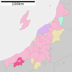
 Myōkō (妙高市, Myōkō-shi) is a city located in Niigata Prefecture, Japan. As of 1 November 2020[update], the city had an estimated population of 31,374 in 12,408 households, and a population density of 70 people per km².[1] The total area of the city was 445.63 square kilometres (172.06 sq mi). Myōkō is a member of the World Health Organization’s Alliance for Healthy Cities (AFHC).[2] GeographyMyōkō is located in an inland region of north-central Niigata Prefecture, on the border of Nagano Prefecture. It lies in mountain surroundings near the historical entrance to the Echigo Plains. The city is surrounded by five mountains. Mount Madarao, Mount Myōkō, Mount Kurohime, Mount Togakushi and Mount Iizuna are collectively known as the Five Mountains of Northern Shinshu (北信五岳, Hokushingogaku). They make up the border of Nagano and Niigata Prefectures. Most of the city is covered with mountains and forests. As the city name implies, Mount Myōkō (2,454 metres; 8,051 ft) is in the city, much of which is within the borders of the Myōkō-Togakushi Renzan National Park. In addition to its namesake, Mount Myōkō, the city is home to two other 100 Famous Japanese Mountains: Mount Hiuchi (2,462 m; 8,077 ft) and Mount Takatsuma (2,353 m; 7,720 ft). Surrounding municipalitiesClimateMyōkō has a Humid climate (Köppen Cfa) characterized by warm, wet summers and cold winters with heavy snowfall. The average annual temperature in Myōkō is 11.9 °C (53.4 °F). The average annual rainfall is 1,924.4 mm (75.76 in) with September as the wettest month. The temperatures are highest on average in August, at around 24.4 °C (75.9 °F), and lowest in January, at around 0.0 °C (32.0 °F).[3]
DemographicsPer Japanese census data,[5] the population of Myōkō has declined steadily over the past 60 years.
HistoryThe area of present-day Myōkō was part of ancient Echigo Province. During the Edo period the area was divided between the holdings of Takada Domain and tenryō territory administered directly by the Tokugawa shogunate. With the creation of the modern municipalities system on June 26, 1890, the village of Arai was created within Nakakubiki District, Niigata. Arai was raised to town status on September 9, 1892 and to city status on November 1, 1954. The city of Myōkō was created on April 1, 2005, by the merger of the city of Arai with the town of Myōkōkōgen, and the village of Myōkō (both from Nakakubiki District). EconomyThe economy of Myōkō is dependent on seasonal tourism, agriculture and forestry, and light manufacturing. GovernmentMyōkō has a mayor-council form of government with a directly elected mayor and a unicameral city legislature of 18 members. Myōkō contributes one member to the Niigata Prefectural Assembly. In terms of national politics, the city is part of Niigata 6th district of the lower house of the Diet of Japan. EducationMyōkō has nine public elementary schools and three public middle schools operated by the city government, and one public high school operated by the Niigata Prefectural Board of Education. The prefecture also operates one special education school for the handicapped. TransportationRailway
HighwayA Note: Jōetsumyōkō station is actually in Jōetsu, 1.5 km away from the border with Myōkō. Local attractions
Sister citiesMyōkō is twinned with: References
External linksWikimedia Commons has media related to Myoko, Niigata.
Information related to Myōkō, Niigata |
||||||||||||||||||||||||||||||||||||||||||||||||||||||||||||||||||||||||||||||||||||||||||||||||||||||||||||||||||||||||||||||||||||||||||||||||||||||||||||||||||||||||||||||||||||||||||||||||||||||||||||||||||||||||||||||||||||||||||||||||||||||||||||||||||


