|
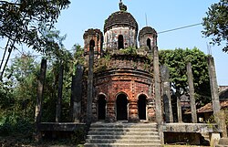
Purbba Gopalpur
Purbba Gopalpur is a village in the Panskua CD block in the Tamluk subdivision of the Purba Medinipur district in the state of West Bengal, India. Geography
8km 5miles
Purbba Gopalpur H
Dakshin Maynadal H
Rupnarayan
Bhabanipur R
Chak Srikrishnapur R
Chandipur R
Nandakumar R
Moyna R
Janu Basan R
Uttar Mechogram R
Shyamsundarpur Patna R
Chatara R
Erashal CT
Kotbar CT
Goasafat CT
Dakshin Baguan CT
Anantapur CT
Shantipur CT
Kakdihi CT
Kharisha CT
Mihitikri CT
Amalhara CT
Kolaghat CT
Panskura M
Tamluk M Cities and towns in Tamluk subdivision of Purba Medinipur district M: municipal city/ town, CT: census town, R: rural/ urban centre, H: historical/ religious centre Owing to space constraints in the small map, the actual locations in a larger map may vary slightly LocationPurbba Gopalpur is located at 22°26′04″N 87°44′50″E / 22.4345°N 87.7472°E. Urbanisation94.08% of the population of Tamluk subdivision live in the rural areas. Only 5.92% of the population live in the urban areas, and that is the second lowest proportion of urban population amongst the four subdivisions in Purba Medinipur district, just above Egra subdivision.[1] Note: The map alongside presents some of the notable locations in the subdivision. All places marked in the map are linked in the larger full screen map. DemographicsAccording to the 2011 Census of India, Purbba Gopalpur had a total population of 1,110, of which 574 (52%) were males and 536 (49%) were females. There were 101 persons in the age range of 0–6 years. The total number of literate persons in Purbba Goplapur was 849 (89.14% of the population over 6 years).[2] Purbba Gopalpur picture gallery
References
Wikimedia Commons has media related to Purba Gopalpur, Panskura CD block. |
||||||||||||||||||||||||||||||||||


