Share to: share facebook share twitter share wa share telegram print page


Shire of Murchison

Shire of Murchison
Western Australia
The Murchison Shire offices
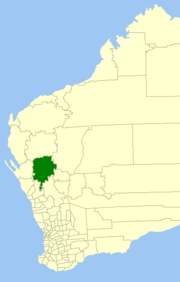
Location in Western Australia
Map
Population101 (LGA 2021)[1]
Established1875
Area49,500 km2 (19,112.1 sq mi)
Shire PresidentRoss Foulkes-Taylor
Council seatMurchison Settlement
RegionMid West
State electorate(s)North West
Federal division(s)Durack
WebsiteShire of Murchison
Mean max temp[2] Mean min temp[2] Annual rainfall[2]
30.5 °C
87 °F
13.6 °C
56 °F
230 mm
9.1 in
LGAs around Shire of Murchison:
Upper Gascoyne Upper Gascoyne Meekatharra
Shark Bay Shire of Murchison Cue
Northampton Greater Geraldton Yalgoo

The Shire of Murchison is a 49,500 km² local government area (LGA), within the Murchison sub-region, in the Mid West region of Western Australia. Encompassing most of the Murchison and East Murchison goldfields, the shire is named after the Murchison River. It is Australia's least-populated LGA and the only one without an official town.[3][4][5] Five sparsely-populated rural localities, with a collective population of 101 (as of 2021), comprise the entire shire. The shire offices, located 300 kilometres (186 mi) northeast of Geraldton, are the focal point of Murchison Settlement, a small part of the Murchison locality.

Description

The Shire of Murchison incorporates 29 pastoral stations and a population of 114[when?]. Most properties are operated by family units with their main income from cattle, meat sheep and wool, with some goats. A small tourism industry is developing in the region with some stations involved in station stays and with the Murchison Oasis Caravan Park and motel units located at the settlement providing facilities for tourists.[5][6]

History

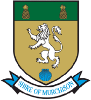
The Shire of Murchison takes its name from the Murchison River, which was named in 1839 by explorer George Grey after Sir Roderick Impey Murchison, President of the Royal Geographical Society of London. The Shire’s logo is based on the coat of arms of his family, Murchison of Tarradale (lion rampant between two pineapples with a scallop shell at the base).[5][7]

The Murchison Road District was gazetted on 3 August 1875. It absorbed the Upper Murchison Road District on 18 March 1912. On 1 July 1961 it became the Shire of Murchison following changes to the Local Government Act, which reformed all remaining road districts into shires.[8][9]

In 2004 the shire was expanded in area when the northern part of the Shire of Mullewa and an eastern section of the Shire of Northampton were incorporated into Murchison.[10]

Murchison Settlement

The Murchison Museum in 2020

In 1966, a new shire office, including a residence for the shire clerk was built, approximately 200 km north of Mullewa on the Carnarvon to Mullewa Road. In 1985, a roadhouse was built nearby and additional shire buildings, including a museum. The area surrounding the shire complex was gazetted as Murchison Settlement in 1988. It has come to include a few other houses and an Australia Post Community Postal Agent (CPA).

Murchison Shire Airport (ICAO airport code: YMSS), which adjoins the townsite, has a 1,448 metre all-weather runway.[3]

Wards

The shire is represented by 7 councillors, and has been divided into two wards. The shire president is elected from among the councillors.

  • Darlot Ward (4 councillors)
  • Ballinyoo Ward (3 councillors)

Prior to 2005, there were 4 wards – Boolardy, Byro, Mileura and Yallalong.

Localities

The localities of the Shire of Murchison with population and size figures based on the most recent Australian census:[11][12]

Locality Population Area Map
East Murchison 0 (SAL 2021)[13] 7,300.6 km2 (2,818.8 sq mi) Map
Murchison 30 (SAL 2021)[14] 23,434.2 km2 (9,048.0 sq mi) Map
Nerramyne 6 (SAL 2021)[15] 1,197.7 km2 (462.4 sq mi) Map
South Murchison 73 (SAL 2021)[16] 11,584.0 km2 (4,472.6 sq mi) Map
Woolgorong 0 (SAL 2021)[17] 1,408.5 km2 (543.8 sq mi) Map

Murchison Radio-astronomy Observatory

The Shire is the site of the Murchison Radio-astronomy Observatory, which lies 70 km east-northeast of Murchison Settlement. A sparse population – and its consequent radio "quietness" – is a factor behind the Shire being selected as one of the two sites for the Square Kilometre Array – a proposed array of radio telescope receivers with a total collecting area of one square kilometre. It is already home to two other major radio telescope facilities: the Murchison Widefield Array and the Australian Square Kilometre Array Pathfinder.

The Square Kilometre Array, or SKA, is a global radio telescope project involving institutions in more than 20 countries. The SKA will be the largest and most capable radio telescope ever constructed—50 times more sensitive than any other radio instrument. Australia and southern Africa will each host different components of the SKA. Management of the facilities at the SKA is coordinated by the CSIRO from the offices and laboratories at the Murchison Radio-astronomy Support Facility in Geraldton.[18]

Heritage-listed places

As of 2023, 35 places are heritage-listed in the Shire of Murchison,[19] of which four are on the State Register of Heritage Places, among them the Boolardy Homestead.[20] The homestead, dating back to 1875, was added to the state register on 29 May 2001.[21]

References

  1. ^ Australian Bureau of Statistics (28 June 2022). "Murchison (Local Government Area)". Australian Census 2021 QuickStats. Retrieved 28 June 2022. Edit this at Wikidata
  2. ^ a b c "Summary statistics Murchison". Climate statistics for Australian locations. Bureau of Meteorology. Retrieved 26 February 2020.
  3. ^ a b SMH Travel (8 February 2004). "Murchison – a vast shire without a town". The Sydney Morning Herald. Retrieved 22 December 2006.
  4. ^ 3218.0 – Regional Population Growth, Australia, 2006–07 — 3218.0 Population Estimates by Statistical Local Area, 2001 to 2007. Australian Bureau of Statistics.
  5. ^ a b c "Annual Report for the year ending 30 June 2015" (PDF). Shire of Murchison, Western Australia. 17 December 2015. Retrieved 29 December 2015.
  6. ^ "Welcome to Murchison". Shire of Murchison. Retrieved 29 December 2015.
  7. ^ Paul, James Balfour (1893). An Ordinary of Arms. Edinburgh: William Green and Sons. p. 165. Retrieved 30 December 2015.
  8. ^ "Municipality Boundary Amendments Register" (PDF). Electoral Boundaries WA. Perth, WA: Office of the Electoral Distribution Commissioners. 31 May 2003. p. 76. Retrieved 21 December 2015.
  9. ^ WA Electoral Commission, Municipality Boundary Amendments Register (release 2.0), 31 May 2003.
  10. ^ "Change of shire for Mid-West pastoral stations". Media Statements. Perth, WA: Government of Western Australia. 30 July 2004. Archived from the original on 22 December 2015. Retrieved 21 December 2015.
  11. ^ "SLIP Map". maps.slip.wa.gov.au. Landgate. Retrieved 26 January 2023.
  12. ^ "NationalMap". nationalmap.gov.au. Geoscience Australia. Retrieved 26 January 2023.
  13. ^ Australian Bureau of Statistics (28 June 2022). "East Murchison (suburb and locality)". Australian Census 2021 QuickStats. Retrieved 28 June 2022. Edit this at Wikidata
  14. ^ Australian Bureau of Statistics (28 June 2022). "Murchison (WA) (suburb and locality)". Australian Census 2021 QuickStats. Retrieved 28 June 2022. Edit this at Wikidata
  15. ^ Australian Bureau of Statistics (28 June 2022). "Nerramyne (suburb and locality)". Australian Census 2021 QuickStats. Retrieved 28 June 2022. Edit this at Wikidata
  16. ^ Australian Bureau of Statistics (28 June 2022). "South Murchison (suburb and locality)". Australian Census 2021 QuickStats. Retrieved 28 June 2022. Edit this at Wikidata
  17. ^ Australian Bureau of Statistics (28 June 2022). "Woolgorong (suburb and locality)". Australian Census 2021 QuickStats. Retrieved 28 June 2022. Edit this at Wikidata
  18. ^ "Murchison Radio-astronomy Observatory Support Facility" (PDF). Australia Telescope National Facility. CSIRO. Retrieved 11 September 2015.
  19. ^ "Shire of Murchison Heritage Places". inherit.stateheritage.wa.gov.au. Heritage Council of Western Australia. Retrieved 24 February 2023.
  20. ^ "Shire of Murchison State Register of Heritage Places". inherit.stateheritage.wa.gov.au. Heritage Council of Western Australia. Retrieved 24 February 2023.
  21. ^ "Boolardy Homestead Group". inherit.stateheritage.wa.gov.au. Heritage Council of Western Australia. Retrieved 13 March 2021.

26°53.61′S 115°57.39′E / 26.89350°S 115.95650°E / -26.89350; 115.95650

Prefix: a b c d e f g h i j k l m n o p q r s t u v w x y z 0 1 2 3 4 5 6 7 8 9

Portal di Ensiklopedia Dunia

Kembali kehalaman sebelumnya