Share to: share facebook share twitter share wa share telegram print page

Tula, American Samoa

Tula
Village
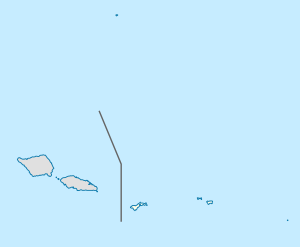
Tula is located in American Samoa
Tula
Tula
Location in American Samoa
Coordinates: 14°15′10″S 170°33′56″W / 14.25278°S 170.56556°W / -14.25278; -170.56556
Country United States
Territory American Samoa
CountyVaifanua
Area
 • Land0.51 sq mi (1.3 km2)
Population
 (2020)
 • Total
308
 • Density794.5/sq mi (306.8/km2)

Tula is a village in the Eastern District of Tutuila Island in American Samoa. Tula is located in Vaifanua County and had a population of 405 as of the 2010 U.S. Census.[1]

Tula is located on Cape Matātula. It is the site of the former upland ridge settlement of Lefutu (AS-21-002).[2] Cape Matatula, which is the northeastern point of Tutuila Island, consists of high rocks that project some distance seaward, forming a prominent headland. The cape's rugged terrain and protruding rocks make it a notable geographical feature.[3]

Etymology

The name of the village, Tula, is derived from the Samoan language and translates into English as “Bald” or “Bare”.[4] Lefutu, which is a hamlet[5] or inland village in Tula, translates to “Barringtonia tree”.[6]

History

Tula was one of the first settlements on Tutuila, having been settled by 600 BCE.[7][8] Numerous ancient artifacts have been discovered at the prehistoric quarry near the town.[9] The Lau'agae Ridge Quarry is the largest of its kind on Tutuila Island.[10]

The prehistoric village of Tulauta (AS-21-1) is located approximately 500 meters inland from the coastal village of Tula. It is situated at the rear of the Tula Valley.[11][12] Large quantities of basalt debris have been found at Tulauta.[13]

In 1985, Gould, Honor, and Reinhardt asserted that the abundance of basalt flakes at the site indicates that Tulauta was among the largest basalt quarries and lithic or adze manufacturing centers in Polynesia. Features identified at the site include 10 to 13 house foundations, two pigsty enclosures, several graves, rock alignments, pits, fireplaces, and walls. One house foundation, elevated higher than the others, is hypothesized to have served as the base for a chief’s house. Additionally, potential evidence of a fale aitu (spirit house) or related structure exists, and a malae (ceremonial ground) may be present in a featureless area dividing the northern and southern clusters of structures. Archaeologists have consistently noted a significant number of basalt artifacts at Tulauta, with over 200 adzes and more than 100 flake tools recovered from the site. Radiocarbon dating results have varied: Frost reported dates of approximately 2560 ± 140 BCE and 630 ± 70 years BCE. Gould obtained dates of 190 ± 80 years BCE and 420 ± 80 years BCE.[14]

Geography

Tula is the easternmost village on Tutuila Island,[15][16] and is situated on the rugged northeast cape of Matātula.[17] It is home to wide, white sand beaches and a prehistoric quarry. The Samoa Observatory, established in 1974 by National Oceanic and Atmospheric Administration (NOAA), sits on Cape Matātula just outside the village of Tula.[18] NASA's Advanced Global Atmospheric Gases Experiment (AGAGE) measures more than 40 trace gases involved in stratospheric ozone depletion, climate change, and air quality at the observatory.[19]

Cape Matā'ula and the nearby village of Onenoa feature small plantations, high cliffs, and forested slopes.[20]

Geology

Tula is closely associated with the geological features of the Olomoana Volcano. The volcanic rocks in this region consist predominantly of olivine basalts, which are geographically limited in extent. Geological studies suggest that these formations resulted from volcanic activity on the northeast rift of the nearby Ālōfau Volcano during the final stages of Pliocene volcanic activity on the island. Evidence of this contemporaneous activity includes the overlapping of Ālōfau volcanic flows on the western slope of the Olomoana volcanic cone. The Olomoana volcanic system spans approximately 2.4 square kilometers and dominates the landscape surrounding the peak near Tula. Notable geological features include several intrusive volcanic plugs, crater fills, and cinder cones, prominently exposed along the eastern coastline. Cape Matatula, within the vicinity of Tula, is recognized as the largest intrusive volcanic plug in the area. This region is characterized by interbedded flows and palagonitized vitric tuffs. Additionally, the Lefulufulu'a trachyte plug intrudes through these layers, adding to the complex geological history of the area. A large, partially exhumed cinder cone is visible in the stream bed that drains towards Tula, offering further insight into the region's volcanic heritage.[21]

Demographics

Year Population[22]
2020 308
2010 405
2000 413
1990 423
1980 347
1970 329
1960 340
1950 261
1940 104
1930 128

Notable people

Composer and radio host Iosefa Salanoa Solatoa (1925-1985) was born and raised in Tula. He composed one of the most popular songs in the Samoan Islands, “Le Eleele ua le Malie i Vai”, and later became President of the Samoan Civic Association of Hawai’i.[23]

References

  1. ^ Census of population and housing (2000): American Samoa Summary Social, Economic, and Housing Characteristics (2000). DIANE Publishing. Pages 13 and 147. ISBN 9781428985490.
  2. ^ Krämer, Augustin (2000). The Samoa Islands. University of Hawaii Press. Pages 497-498 and 432. ISBN 9780824822194.
  3. ^ U.S. Defense Mapping Agency (1977). "Sailing Directions for the Pacific Islands: Volume 3, the South-central Groups". U.S. Department of Defense. Page 169.
  4. ^ Churchill, W. (1913). "Geographical Nomenclature of American Samoa". Bulletin of the American Geographical Society, 45(3), page 193. Retrieved on December 6, 2024, from https://doi.org/10.2307/199273.
  5. ^ Krämer, Augustin (1994). The Samoa Islands: Constitution, pedigrees and traditionsUniversity of Hawaiʻi Press. Page 432. ISBN 9780824816339.
  6. ^ Churchill, W. (1913). Geographical Nomenclature of American Samoa. Bulletin of the American Geographical Society, 45(3), page 192. Retrieved on December 6, 2024, from https://doi.org/10.2307/199273.
  7. ^ Lonely Planet (1990). Samoa: Western & American Samoa. Lonely Planet Publications. Page 135. ISBN 9780864420787.
  8. ^ Stanley, David (1999). Moon Handbooks Tonga-Samoa. Moon Travel Handbooks. Page 163. ISBN 9781566911740.
  9. ^ Murrow, Tony and Malama Meleisea (2000). Samoa: Pacific Pride. Pasifika Press. Page 42. ISBN 9780908597192.
  10. ^ Stubbs, John and William Chapman (2023). Architectural Conservation in Australia, New Zealand and the Pacific Islands: National Experiences and Practice. Taylor & Francis. ISBN 9781003807940.
  11. ^ Clark, Jeffrey T. and David J. Herdrich (1988). “The Eastern Tutuila Archaeological Project, 1986: Final Report”. The Eastern Tutuila Archaeological Project, 1986. Page 26.
  12. ^ Weisler, Marshall (1997). Prehistoric Long-distance Interaction in Oceania: An Interdisciplinary Approach. New Zealand Archaeological Association. Page 73. ISBN 9780959791549.
  13. ^ Birx, H. James (2006). Encyclopedia of Anthropology. SAGE Publications. Page 2049. ISBN 9781452265360.
  14. ^ Clark, J. T., & Herdrich, D. J. (1993). "PREHISTORIC SETTLEMENT SYSTEM IN EASTERN TUTUILA, AMERICAN SAMOA". The Journal of the Polynesian Society, 102(2), pages 157–158 and 166. Retrieved on December 11, 2024, from http://www.jstor.org/stable/20706503.
  15. ^ Lonely Planet (1990). Samoa: Western & American Samoa. Lonely Planet Publications. Page 148. ISBN 9780864420787.
  16. ^ Swaney, Deanna (1994). Samoa: Western & American Samoa: a Lonely Planet Travel Survival Kit. Lonely Planet Publications. Page 178. ISBN 9780864422255.
  17. ^ Krämer, Augustin (2000). The Samoa Islands: An Outline of a Monograph With Particular Consideration of German Samoa. University of Hawaii Press. Page 432. ISBN 9780824822194.
  18. ^ Stanley, David (2004). Moon Handbooks South Pacific. Page 479. ISBN 9781566914116.
  19. ^ "Cape Matatula". Advanced Global Atmospheric Gases Experiment. NASA. Retrieved 12 April 2022.
  20. ^ Swaney, Deanna (1994). Samoa: Western & American Samoa: a Lonely Planet Travel Survival Kit. Lonely Planet Publications. Page 178. ISBN 9780864422255.
  21. ^ Keating, Barbara H. and Barrie R. Bolton (2012). Geology and Offshore Mineral Resources of the Central Pacific Basin. Springer New York. Page 152. ISBN 9781461228967.
  22. ^ "American Samoa Statistical Yearbook 2016" (PDF). American Samoa Department of Commerce.
  23. ^ Sunia, Fofō Iosefa Fiti (2001). Puputoa: Host of Heroes - A record of the history makers in the First Century of American Samoa, 1900-2000. Suva, Fiji: Oceania Printers. Pages 133-134. ISBN 9829036022.

Read other articles:

Peta infrastruktur dan tata guna lahan di Komune La Roche-l'Abeille.  = Kawasan perkotaan  = Lahan subur  = Padang rumput  = Lahan pertanaman campuran  = Hutan  = Vegetasi perdu  = Lahan basah  = Anak sungaiLa Roche-l'Abeille merupakan sebuah komune di departemen Haute-Vienne di Prancis. Lihat pula Komune di departemen Haute-Vienne Referensi INSEE lbsKomune di departemen Haute-Vienne Aixe-sur-Vienne Ambazac Arnac-la-Poste Augne Aureil Azat-le-Ris Balle…

Artikel ini sebatang kara, artinya tidak ada artikel lain yang memiliki pranala balik ke halaman ini.Bantulah menambah pranala ke artikel ini dari artikel yang berhubungan atau coba peralatan pencari pranala.Tag ini diberikan pada Oktober 2022. Kamp pengungsi Kutupalong Kamp pengungsi Kutupalong (bahasa Bengali: কুতুপালং শরনার্থী শিবির ) adalah sebuah kamp pengungsi yang terletak di Ukhia, Cox's Bazar, Bangladesh. Sebagian besar penghuninya adalah pe…

City in the United States This article is about the city in Oregon. For the nearby geological formation, see Celilo Falls. For other uses, see Dalles. Not to be confused with the city of Dallas, Oregon. City in Wasco CountyThe DallesCityCity of the DallesThe Dalles and the Columbia River in November 2008 FlagSealMotto(s): Cognito timor Vincit (Latin), Knowledge Conquers Fear (English)Location in OregonCoordinates: 45°36′06″N 121°10′30″W / 45.60167°N 121.17500°W&#…

يفتقر محتوى هذه المقالة إلى الاستشهاد بمصادر. فضلاً، ساهم في تطوير هذه المقالة من خلال إضافة مصادر موثوق بها. أي معلومات غير موثقة يمكن التشكيك بها وإزالتها. (ديسمبر 2018) الانتخابات التشريعية التونسية 1986  →1981 2 نوفمبر 1986 1989←  125 مقعدًا في مجلس النوابالمقاعد اللازمة للأغل…

Mexican politician In this Spanish name, the first or paternal surname is Polevnsky and the second or maternal family name is Gurwitz. This biography of a living person needs additional citations for verification. Please help by adding reliable sources. Contentious material about living persons that is unsourced or poorly sourced must be removed immediately from the article and its talk page, especially if potentially libelous.Find sources: Yeidckol Polevnsky – news …

العلاقات الإستونية الليتوانية إستونيا ليتوانيا   إستونيا   ليتوانيا تعديل مصدري - تعديل   العلاقات الإستونية الليتوانية هي العلاقات الثنائية التي تجمع بين إستونيا وليتوانيا.[1][2][3][4][5] مقارنة بين البلدين هذه مقارنة عامة ومرجعية للدولتين: وج…

Institut Agama Islam Negeri KediriIAIN KediriLogo Institut Agama Islam Negeri KediriJenisPerguruan Tinggi Islam NegeriDidirikan1997Lembaga indukKementerian Agama Republik IndonesiaAfiliasiIslamRektorDr. Wahidul Anam, M.Ag.AlamatJalan Sunan Ampel, No. 7, Kelurahan Ngronggo, Kota Kediri, Kota KediriSitus webIAIN KediriInstitut Agama Islam Negeri Kediri disingkat IAIN Kediri merupakan salah satu perguruan tinggi keagamaan Islam negeri yang terletak Kota Kediri, Jawa Timur, tepatnya di Jalan Sunan A…

This article needs a plot summary. Please add one in your own words. (January 2022) (Learn how and when to remove this template message) 1965 Japanese filmIllusion of BloodDirected byShirō ToyodaScreenplay byToshio YasumiBased onTokaido Yotsuya kaidanby Nanboku TsuruyaProduced byIchiro SatoHideyuki ShiinoStarringTatsuya NakadaiMariko OkadaCinematographyHiroshi MuraiMusic byToru TakemitsuProductioncompanyTokyo EigaDistributed byTohoRelease date 25 July 1965 (1965-07-25) (Japan…

1971 single by Nitty Gritty Dirt Band House at Pooh CornerSingle by Nitty Gritty Dirt Bandfrom the album Uncle Charlie & His Dog Teddy B-sideTravelin' MoodReleasedApril 12, 1971GenreRockLength2:39LabelLibertySongwriter(s)Kenny LogginsProducer(s)William McEuenNitty Gritty Dirt Band singles chronology Mr. Bojangles (1970) House at Pooh Corner (1971) Some of Shelly's Blues (1971) House at Pooh Corner is a song written by Kenny Loggins, based on the children's book of the same name. It was first…

Place in Centre-Est Region, Burkina FasoGuellaCountry Burkina FasoRegionCentre-Est RegionProvinceBoulgou ProvinceDepartmentTenkodogo DepartmentPopulation (2005 est.) • Total706 Guella is a village in the Tenkodogo Department of Boulgou Province in south-eastern Burkina Faso. As of 2005, the village has a population of 706.[1] References ^ Burkinabé government inforoute communale Archived 2008-10-11 at the Wayback Machine vte Boulgou ProvinceCapital: TenkodogoBagré…

QQ MusicTipeperangkat lunak dan layanan streaming musik Versi pertama2005 Versi stabilDaftarMicrosoft Windows: 15.9.0.0 (9 April 2018)Microsoft Windows: 15.9.5.0 (18 Mei 2018) GenreStreaming musikLisensiPerangkat lunak milik peroranganBahasaDaftar bahasa Tionghoa sederhana Karakteristik teknisSistem operasiMicrosoft Windows XP dan diatasnya, Google Android, Apple MacOS, Apple iOSPlatformiOS Ukuran13.9 MB (bagi Windows), 24.08MB (bagi Android), 32.8MB (bagi MacOS)Bahasa pemrogramanC++ Inform…

Gerbang masuk menuju Vihara Bahtera Bakti atau biasa disebut Kelenteng Ancol Da Bo Gong (Hanzi: 大伯公, pinyin: Tua Pek Kong) atau Vihara Bahtera Bakti adalah kelenteng tertua di Jakarta, selain Kim Tek Ie atau Vihara Dharma Bakti. Vihara atau Kelenteng ini terletak di kawasan Taman Impian Jaya Ancol, tepatnya di Jalan Pantai Sanur V, Ancol, Pademangan, Jakarta Utara.[1] Klenteng Ancol yang dikenal dengan Vihara Bahtera Bhakti menyimpan banyak kisah di balik dinding bangunan yang tida…

Artikel atau sebagian dari artikel ini mungkin diterjemahkan dari Aamir Khan filmography di en.wikipedia.org. Isinya masih belum akurat, karena bagian yang diterjemahkan masih perlu diperhalus dan disempurnakan. Jika Anda menguasai bahasa aslinya, harap pertimbangkan untuk menelusuri referensinya dan menyempurnakan terjemahan ini. Anda juga dapat ikut bergotong royong pada ProyekWiki Perbaikan Terjemahan. (Pesan ini dapat dihapus jika terjemahan dirasa sudah cukup tepat. Lihat pula: panduan pene…

JendiInformasi publikasiPenerbitCIAYO ComicsGenreOlahragaTanggal penerbitan30 Agustus 2018 - 1 November 2018Tim kreatifDitulis olehFahmi HamkaTonny HanggoroArtisDS Studio Jendi adalah komik web karangan tim komikus Fahmi Hamka, Tonny Hanggoro, dan DS Studio. Komik ini terbit di CIAYO Comics pada tanggal 30 Agustus hingga 1 November 2018.[1][2] Komik Jendi menceritakan kisah hidup perenang difabel Jendi Pangabean, untuk menyambut perhelatan Asian Para Games 2018 di Jakarta.[3&…

 烏克蘭總理Прем'єр-міністр України烏克蘭國徽現任杰尼斯·什米加尔自2020年3月4日任命者烏克蘭總統任期總統任命首任維托爾德·福金设立1991年11月后继职位無网站www.kmu.gov.ua/control/en/(英文) 乌克兰 乌克兰政府与政治系列条目 宪法 政府 总统 弗拉基米尔·泽连斯基 總統辦公室 国家安全与国防事务委员会 总统代表(英语:Representatives of the President of Ukraine) 总理…

  هذه المقالة عن الجنة في الإسلام. لمعانٍ أخرى، طالع جنة. جزء من سلسلة مقالات حولالإسلام العقيدة الإيمان توحيد الله  الإيمان بالملائكة الإيمان بالكتب السماوية الإيمان بالرسل والأنبياء الإيمان باليوم الآخر الإيمان بالقضاء والقدر أركان الإسلام شهادة أن لا إله إلا الل…

AEGON Championships 2010 Sport Tennis Data 7 giugno – 13 giugno Edizione 108a Categoria ATP World Tour 250 Superficie Erba Località Londra, Regno Unito Campioni Singolare Sam Querrey Doppio Novak Đoković / Jonathan Erlich 2009 2011 L'AEGON Championships 2010 è stato un torneo di tennis disputato su campi di erba, facente parte dell'ATP World Tour 250 Series, nell'ambito dell'ATP World Tour 2010. È stata la 108ª edizione dell'evento, e si è giocata nell'impianto del Queen's Club a Londra…

Chang'e 5Peluncuran Chang'e 5Jenis misiPengembalian sampel BulanOperatorCNSACOSPAR ID2020-087ASATCAT no.47097Durasi misi1268 hari, 10 jam, 29 menit Properti wahanaProdusenCASTMassa luncur8.200 kg (18.100 pon)[1] Awal misiTanggal luncur23 November 202020:30 UTC24 November 20204:30 CST[2]Roket peluncurLong March 5Tempat peluncuranWenchangKontraktorCALT Akhir MisiTanggal mendarat17 Desember 2020 Pengorbit BulanPenyisipan orbit28 November 202012:58 UTC[3&…

Payment processing company This article contains content that is written like an advertisement. Please help improve it by removing promotional content and inappropriate external links, and by adding encyclopedic content written from a neutral point of view. (July 2023) (Learn how and when to remove this message) BC CardLogo since 2009Native name비씨카드 주식회사Company typeSubsidiaryIndustryFinancial servicesFounded1982; 42 years ago (1982)HeadquartersSeoul, South Korea…

The Asian Beach Handball Championship is the official competition for senior men's and women's national beach handball teams of Asia.[1] Men Summary Year Host Final Third place match Champion Score Runner-up Third place Score Fourth place 2004Details Muscat Oman No playoffs Bahrain Pakistan No playoffs Iran 2007Details Bandar Abbas Pakistan No playoffs Iran Japan No playoffs None awarded 2011Details Muscat Qatar No playoffs Oman Kuwait No playoffs Pakistan 2013Details Hong Kong Qatar No …

Kembali kehalaman sebelumnya