Share to: share facebook share twitter share wa share telegram print page

Wapello County, Iowa

Wapello County
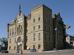
The courthouse in Ottumwa
Map of Iowa highlighting Wapello County
Location within the U.S. state of Iowa
Map of the United States highlighting Iowa
Iowa's location within the U.S.
Coordinates: 41°01′46″N 92°24′32″W / 41.029444444444°N 92.408888888889°W / 41.029444444444; -92.408888888889
Country United States
State Iowa
Founded1843
Named forWapello
SeatOttumwa
Largest cityOttumwa
Area
 • Total436 sq mi (1,130 km2)
 • Land432 sq mi (1,120 km2)
 • Water4.2 sq mi (11 km2)  1.0%
Population
 (2020)
 • Total35,437
 • Density81/sq mi (31/km2)
Time zoneUTC−6 (Central)
 • Summer (DST)UTC−5 (CDT)
Congressional district2nd
Websitewww.wapellocounty.org
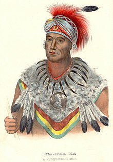
Chief Wapello; "Wa-pel-la the Prince, Musquakee Chief", from History of the Indian Tribes of North America.

Wapello County is a county located in the U.S. state of Iowa. As of the 2020 census, the population was 35,437.[1] The county seat is Ottumwa.[2] The county was formed on February 17, 1843, and named for Wapello, a Meskwaki chief.[3]

Wapello County is included in the Ottumwa, IA Micropolitan Statistical Area.

Geography

According to the U.S. Census Bureau, the county has a total area of 436 square miles (1,130 km2), of which 432 square miles (1,120 km2) is land and 4.2 square miles (11 km2) (1.0%) is water.[4]

Major highways

Transit

Adjacent counties

Demographics

Historical population
CensusPop.Note
18508,471
186014,51871.4%
187022,34653.9%
188025,28513.2%
189030,42620.3%
190035,42616.4%
191037,7436.5%
192037,9370.5%
193040,4806.7%
194044,2809.4%
195047,3977.0%
196046,126−2.7%
197042,149−8.6%
198040,241−4.5%
199035,696−11.3%
200036,0511.0%
201035,625−1.2%
202035,437−0.5%
2023 (est.)35,166[5]−0.8%
U.S. Decennial Census[6]
1790-1960[7] 1900-1990[8]
1990-2000[9] 2010-2018[10]
Population of Wapello County from US census data

2020 census

2022 US Census population pyramid for Wapello County from ACS 5-year estimates

The 2020 census recorded a population of 35,437 in the county, with a population density of 81.2225/sq mi (31.3602/km2). There were 15,734 housing units, of which 14,167 were occupied.[1]

Wapello County Racial Composition[11]
Race Num. Perc.
White (NH) 27,295 77.02%
Black or African American (NH) 1,443 4.1%
Native American (NH) 66 0.2%
Asian (NH) 622 1.8%
Pacific Islander (NH) 518 1.5%
Other/Mixed (NH) 1,161 3.3%
Hispanic or Latino 4,332 12.22%

2010 census

The 2010 census recorded a population of 35,625 in the county, with a population density of 82.5016/sq mi (31.8540/km2). There were 16,098 housing units, of which 14,552 were occupied.[12]

2000 census

As of the census[13] of 2000, there were 36,051 people, 14,784 households, and 9,801 families residing in the county. The population density was 84 people per square mile (32 people/km2). There were 15,873 housing units at an average density of 37 units per square mile (14 units/km2). The racial makeup of the county was 96.28% White, 0.93% Black or African American, 0.28% Native American, 0.65% Asian, 0.02% Pacific Islander, 1.05% from other races, and 0.79% from two or more races. 2.22% of the population were Hispanic or Latino of any race.

There were 14,784 households, out of which 28.80% had children under the age of 18 living with them, 52.70% were married couples living together, 9.90% had a female householder with no husband present, and 33.70% were non-families. 28.20% of all households were made up of individuals, and 13.40% had someone living alone who was 65 years of age or older. The average household size was 2.37 and the average family size was 2.89.

In the county, the population was spread out, with 23.30% under the age of 18, 9.70% from 18 to 24, 26.00% from 25 to 44, 23.30% from 45 to 64, and 17.80% who were 65 years of age or older. The median age was 39 years. For every 100 females there were 94.80 males. For every 100 females age 18 and over, there were 91.70 males.

The median income for a household in the county was $32,188, and the median income for a family was $39,224. Males had a median income of $31,346 versus $21,286 for females. The per capita income for the county was $16,500. About 9.40% of families and 13.20% of the population were below the poverty line, including 18.00% of those under age 18 and 7.90% of those age 65 or over.

Communities

Cities

Unincorporated communities

Townships

Population ranking

The population ranking of the following table is based on the 2020 census of Wapello County.[1]

county seat

Rank City/Town/etc. Municipal type Population (2020 Census)
1 Ottumwa City 25,529
2 Eddyville (partially in Mahaska and Monroe Counties) City 970
3 Eldon City 783
4 Agency City 620
5 Blakesburg City 274
6 Kirkville City 157
7 Chillicothe City 76

Politics

Between 1864 and 1928, Wapello County backed the Republican candidate in every election except 1912, when former Republican Theodore Roosevelt ran as the Progressive candidate, fracturing the Republican party and allowing Democrat Woodrow Wilson to take the county with a plurality of the vote of less than 37%. From 1932 to 2012, the county voted Democratic in every election except two, the nationwide Republican landslides of Dwight D. Eisenhower in 1952 and Richard Nixon in 1972. Beginning in 2016, Wapello County has shifted back to the Republican column, as Donald Trump carried the county in both 2016 and 2020, winning by a margin of over 20% in 2016 and over 23% in 2020. Also in 2020, Trump became the first candidate from any party to obtain at least 60% of the county's vote since Michael Dukakis in 1988, and the first Republican to do so since Herbert Hoover in 1928.

United States presidential election results for Wapello County, Iowa[14]
Year Republican Democratic Third party
No.  % No.  % No.  %
2020 9,516 60.87% 5,821 37.24% 296 1.89%
2016 8,715 57.53% 5,594 36.93% 840 5.54%
2012 6,789 43.05% 8,663 54.93% 318 2.02%
2008 6,663 41.80% 8,820 55.33% 457 2.87%
2004 7,403 44.31% 9,125 54.62% 179 1.07%
2000 6,313 41.70% 8,355 55.19% 471 3.11%
1996 4,828 32.69% 8,437 57.12% 1,505 10.19%
1992 4,852 30.17% 8,670 53.91% 2,561 15.92%
1988 5,350 34.14% 10,177 64.93% 146 0.93%
1984 7,098 39.88% 10,545 59.24% 157 0.88%
1980 7,475 42.31% 8,923 50.50% 1,270 7.19%
1976 6,786 39.30% 10,249 59.35% 233 1.35%
1972 9,301 51.19% 8,348 45.94% 522 2.87%
1968 7,825 41.96% 9,375 50.28% 1,447 7.76%
1964 5,524 28.26% 13,971 71.48% 51 0.26%
1960 11,036 49.79% 11,116 50.15% 15 0.07%
1956 10,401 48.65% 10,960 51.26% 20 0.09%
1952 11,571 52.24% 10,449 47.17% 130 0.59%
1948 7,875 41.50% 10,841 57.13% 260 1.37%
1944 8,244 43.19% 10,732 56.22% 113 0.59%
1940 9,039 43.03% 11,880 56.56% 87 0.41%
1936 7,647 41.31% 10,578 57.14% 287 1.55%
1932 7,256 42.49% 9,504 55.66% 316 1.85%
1928 11,586 66.10% 5,793 33.05% 149 0.85%
1924 9,870 56.96% 3,039 17.54% 4,420 25.51%
1920 9,884 67.99% 4,131 28.42% 522 3.59%
1916 4,398 47.65% 3,994 43.28% 837 9.07%
1912 2,755 32.53% 3,102 36.62% 2,613 30.85%
1908 4,541 50.69% 3,724 41.57% 694 7.75%
1904 4,912 60.60% 2,473 30.51% 720 8.88%
1900 4,742 53.21% 3,902 43.78% 268 3.01%
1896 4,319 50.75% 4,041 47.49% 150 1.76%

See also

References

  1. ^ a b c "2020 Census State Redistricting Data". census.gov. United states Census Bureau. Retrieved August 12, 2021.
  2. ^ "Find a County". National Association of Counties. Retrieved June 7, 2011.
  3. ^ "Wapello County". Archived from the original on April 26, 2007. Retrieved January 20, 2008.
  4. ^ "US Gazetteer files: 2010, 2000, and 1990". United States Census Bureau. February 12, 2011. Retrieved April 23, 2011.
  5. ^ "Annual Estimates of the Resident Population for Counties: April 1, 2020 to July 1, 2023". United States Census Bureau. Retrieved April 2, 2024.
  6. ^ "U.S. Decennial Census". United States Census Bureau. Retrieved July 20, 2014.
  7. ^ "Historical Census Browser". University of Virginia Library. Retrieved July 20, 2014.
  8. ^ "Population of Counties by Decennial Census: 1900 to 1990". United States Census Bureau. Retrieved July 20, 2014.
  9. ^ "Census 2000 PHC-T-4. Ranking Tables for Counties: 1990 and 2000" (PDF). United States Census Bureau. Archived (PDF) from the original on March 27, 2010. Retrieved July 20, 2014.
  10. ^ "State & County QuickFacts". United States Census Bureau. Archived from the original on August 6, 2011. Retrieved July 20, 2014.
  11. ^ "P2 HISPANIC OR LATINO, AND NOT HISPANIC OR LATINO BY RACE – 2020: DEC Redistricting Data (PL 94-171) – Wapello County, Iowa".
  12. ^ "Population & Housing Occupancy Status 2010" (PDF). United States Census Bureau American FactFinder. Archived (PDF) from the original on October 16, 2020. Retrieved August 15, 2022.
  13. ^ "U.S. Census website". United States Census Bureau. Retrieved January 31, 2008.
  14. ^ Leip, David. "Dave Leip's Atlas of U.S. Presidential Elections". uselectionatlas.org. Retrieved April 28, 2018.

External links

41°01′46″N 92°24′32″W / 41.02944°N 92.40889°W / 41.02944; -92.40889

Read more information:

Artikel ini bukan mengenai lembayung. Untuk kegunaan lain, lihat binahong dan piahong. Wikispecies mempunyai informasi mengenai Lembayung malabar. Lembayung malabar Basella alba Lembayung malabar (gandola) varian merah dan hijau TaksonomiDivisiTracheophytaSubdivisiSpermatophytesKladAngiospermaeKladmesangiospermsKladeudicotsKladcore eudicotsOrdoCaryophyllalesFamiliBasellaceaeGenusBasellaSpesiesBasella alba Linnaeus, 1753 lbs Lembayung malabar,[1] basella rubra,[2] bayam sailan, …

Cari artikel bahasa  Cari berdasarkan kode ISO 639 (Uji coba)   Cari berdasarkan nilai Glottolog   Kolom pencarian ini hanya didukung oleh beberapa antarmuka Halaman rumpun acak Rumpun bahasaArab Semenanjung Bahasa Arab JazirahBahasa Arab SelatanPersebaranSemenanjung ArabPenggolongan bahasaAfroasiatikSemitSemit TengahArabArab SemenanjungKode bahasaGlottologarab1393  Portal BahasaSunting kotak info • L • B • PWBantuan penggunaan templat ini Gambaran keselu…

Jagoan WushuGenre Drama Roman Fantasi Laga PembuatMD EntertainmentDitulis olehAviv ElhamCeritaAviv ElhamPemeran Randy Pangalila Ahmad Ridho Dinda Kirana Choky Adriano Rientammy Daniel Shivaei Ananda Faturrahman Tenno Ali Vitta Mariana Cheika Cathy Fakandi Adi Bing Slamet Mastur Lagu pembukaSang Jagoan — Theo BarlayLagu penutupSang Jagoan — Theo BarlayNegara asalIndonesiaJmlh. musim2Jmlh. episode76 (daftar episode)ProduksiProduser Dhamoo Punjabi Manoj Punjabi Pengaturan kameraMulti-cameraRuma…

1958 film The BeatniksDirected byPaul FreesWritten byPaul FreesArthur JulianProduced byEdward HeiteRon MillerStarringSee belowCinematographyMurray De AtleyEdited byHarold WhiteRelease dates1958 (copyright)1959 (premier)Running time77 minutesCountryUnited StatesLanguageEnglish The Beatniks (1959) by Paul Frees The Beatniks is an American crime film in the teensploitation genre[1] directed by Paul Frees that was filmed in 1958 and released in 1959. It was also featured on the movie-mocking…

2004 film by Tony Mark The MailmanDVD released by IFM World ReleasingDirected byTony MarkWritten byBrian MazoProduced byErin Starr Todd WadeStarringJesse Merrill Rob Arbogast Colene Taylor Jamielyn Kane Diana Kauffman Bryan W. Lukasik Gordon Anthony DavisCinematographyCourtney JonesEdited byTony Mark Todd WadeMusic byDavid WeinsteinProductioncompanyRolling Pictures Inc.Distributed byIFM World ReleasingRelease dates July 13, 2004 (2004-07-13) (Los Angeles, California) [1 …

Katedral AptKatedral Santa AnnaPrancis: Cathédrale Sainte-Anne d'Aptcode: fr is deprecated Katedral AptLokasiApt, VaucluseNegara[ PrancisDenominasiGereja Katolik RomaSejarahDidirikan1795DedikasiMariaArsitekturStatusParokiTipe arsitekturgerejaGayaRomanesque, BarokSelesai1810AdministrasiKeuskupan AgungKeuskupan Agung AvignonKlerusUskupJean-Pierre Cattenoz Katedral Apt yang bernama resmi Katedral Santa Anna (Cathédrale Sainte-Anne d'Apt) adalah sebuah gereja paroki Katolik dan bekas katedral…

Bangau hitam Ciconia nigra Di Taman Nasional Kruger, Afrika SelatanStatus konservasiRisiko rendahIUCN22697669 TaksonomiKerajaanAnimaliaFilumChordataKelasAvesOrdoCiconiiformesFamiliCiconiidaeTribusCiconiiniGenusCiconiaSpesiesCiconia nigra Linnaeus, 1758 Tata namaSinonim taksonArdea nigra Linnaeus, 1758DistribusiRange of C. nigra      Breeding      Resident      Passage      Non-breeding lbs Ba…

Tombs of Mughal emperos Mughal tombs are a set of tombs built by various ruling in Mughal Emperors. All of them have marked influence from Iranian Timurid forms. The Mughal dynasty was established after the victory of Babur at Panipat in 1526. During his five-year reign, Babur took considerable interest in erecting buildings, though few have survived. His grandson Akbar built widely, and the style developed vigorously during his reign. Among his accomplishments were Agra Fort, the fort-city of F…

Avraham Shohat Avraham Shochat (atau Shohat; lahir 1936 di Tel Aviv) adalah politikus Israel. Dialah seorang pendiri kota Arad dan wali kotanya pada periode 1967-1989. Pada 1988, ia menjadi anggota Knesset dan menjabat Menteri Keuangan pada periode 1992-1996 dan 1999-2001. Didahului oleh:Meir Sheetrit Menteri Keuangan Israel1999–2001 Diteruskan oleh:Silvan Shalom Referensi Avraham Shochat in Jewish Virtual Library. Retrieved 11 Januari 2006. Artikel bertopik biografi Israel ini adalah seb…

Artikel ini sebatang kara, artinya tidak ada artikel lain yang memiliki pranala balik ke halaman ini.Bantulah menambah pranala ke artikel ini dari artikel yang berhubungan atau coba peralatan pencari pranala.Tag ini diberikan pada Oktober 2022. Cagar Alam Gunung Dua Saudara adalah cagar alam yang terletak di Kota Bitung, Sulawesi Utara. Kawasan ini ditetapkan sebagai cagar alam berdasarkan Surat Keputusan Menteri Pertanian Nomor 700/Kpts/Um/2/1978 tertanggal13 November 1978. Lahan yang digunakan…

Pertandingan Calcio Fiorentino pada tahun 2008. Calcio Fiorentino atau calcio storico (dalam bahasa Italia) yang berarti sepakbola kuno atau sepak bola zaman dulu, adalah perayaan yang menggabungkan sepak bola, rugby, dan perkelahian. Acara ini rutin diadakan di Italia. Permainan ini berkembang pertama kali pada abad ke-16 di Italia. Meskipun dulu dipraktikkan secara luas, tetapi diperkirakan awalnya bermula di Piazza Santa Croce, Firenze. Sehingga berkembanglah nama giuoco del calcio fiorentino…

Powiat Wysokie Mazowieckie Lambang Powiat Włodawa Lokasi Powiat Włodawa Informasi Negara Polandia Provinsi Lublin Ibu kota Włodawa (kota) Luas 1.256,27 km² Penduduk 39 148 (30 Juni 2016) Kadar urbanisasi 34,08 % Kode internasional (+48) 82 Pelat nomor kendaraan bermotor LWL Pembagian administratif Kota 1 Kota kecamatan: - Kelurahan 7 Politik (Status: ) Bupati (Starost) Andrzej Romańczuk Alamat al. J. Piłsudskiego 24 22-200 Włodawa Situs web resmi https://powiatwlodawski.pl/ Powi…

Ne doit pas être confondu avec Nouveau Taipei. Taïpei Taipei Taïpei, 臺北市 Héraldique Drapeau De haut en bas, de gauche à droite : panorama de Taipei, station de métro Jiantan, Grand Hôtel, fête des lanternes sur la place de la Liberté, skyline de Tapei avec la Taipei 101, païfang du Musée national du Palais. Administration Pays Taïwan Maire Mandat Chiang Wan-an (en) (KMT) 2022- Démographie Gentilé Taipéien, Taipéienne[1] Population 2 602 418 hab. (20…

Pour les articles homonymes, voir Mauves (homonymie). Mauves Administration Pays France Région Auvergne-Rhône-Alpes Département Ardèche Arrondissement Tournon-sur-Rhône Intercommunalité Arche Agglo(siège) Maire Mandat Jean-Paul Bulinge 2020-2026 Code postal 07300 Code commune 07152 Démographie Gentilé Malvinois, Malvinoises Populationmunicipale 1 188 hab. (2021 ) Densité 169 hab./km2 Géographie Coordonnées 45° 02′ 21″ nord, 4° 49′ 48″…

Cet article est une ébauche concernant le cinéma. Vous pouvez partager vos connaissances en l’améliorant (comment ?) selon les conventions filmographiques. Le film 9,5 mm est un format de film cinéma d'une largeur de 9,5 mm, lancé par Pathé en 1922. Présentation La particularité de ce format réside dans la présence, entre chaque image, de perforations d’entraînement centrales. Cette géométrie permet ainsi d'utiliser toute la largeur du film présente un avantage …

For the town in Vermont, see Canaan, Vermont. Town in New Hampshire, United StatesCanaan, New HampshireTownChurch Street in 1907 SealMotto(s): Land of Milk and HoneyLocation in Grafton County, New HampshireCoordinates: 43°38′48″N 72°00′37″W / 43.64667°N 72.01028°W / 43.64667; -72.01028CountryUnited StatesStateNew HampshireCountyGraftonIncorporated1761VillagesCanaanCanaan CenterCanaan StreetWest CanaanGovernment • Select BoardDan…

Village in Tōhoku, JapanShingō 新郷村VillageShingō Village Office FlagSealLocation of Shingō in Aomori PrefectureShingō Coordinates: 40°27′49.19″N 141°10′27.53″E / 40.4636639°N 141.1743139°E / 40.4636639; 141.1743139CountryJapanRegionTōhokuPrefectureAomoriDistrictSannoheArea • Total150.77 km2 (58.21 sq mi)Population (February 28, 2023) • Total2,192 • Density15/km2 (38/sq mi)Time zoneUTC…

ОбластьЯмболская областьболг. Област Ямбол 42°25′ с. ш. 26°31′ в. д.HGЯO Страна  Болгария Входит в Юго-Восточный регион Включает 5 общин Адм. центр Ямбол Областной управитель Димитар Иванов История и география Дата образования 8 января 1999 Площадь 3335,5 км² (17-е ме…

Artikel ini sebatang kara, artinya tidak ada artikel lain yang memiliki pranala balik ke halaman ini.Bantulah menambah pranala ke artikel ini dari artikel yang berhubungan atau coba peralatan pencari pranala.Tag ini diberikan pada Oktober 2022. Ishikawajima Tsu-11 adalah motorjet yang diproduksi dalam jumlah kecil di Jepang pada tahap penutupan Perang Dunia II. Mwsin itu pada prinsipnya dirancang untuk mendorong bom terbang Yokosuka MXY7 Ohka Jepang, senjata kamikaze. Referensi Goodwin, Mike; St…

Malaysian TV series or program One in a MillionOne in a MillionDirected bySunil Kumar (Season 1) Michael Christian Simon (Season 1)Presented byAwal AshaariMarion CaunterJudgesSyafinaz Selamat Paul MossOpening themeStar by Jaclyn VictorCountry of originMalaysiaNo. of episodes18 (Season 1) 9 (Season 2) 10 (Season 3)ProductionExecutive producersSunil Kumar (Season 1 & 3) Mas Ayu Hj. Ali (Season 2)Production locationsSri Pentas 2, Shah Alam Putra World Trade Centre, Kuala LumpurRunning timeVarie…

Kembali kehalaman sebelumnya