Tištín
Cet article est une ébauche concernant une localité tchèque.
| Tištín | |

| |
 |
 |
| Administration | |
|---|---|
| Pays | |
| Région | |
| District | Prostějov |
| Région historique | Moravie |
| Code postal | 798 29 |
| Indicatif téléphonique international | +(420) |
| Démographie | |
| Population | 468 hab. (2025) |
| Densité | 57 hab./km2 |
| Géographie | |
| Coordonnées | 49° 18′ 25″ nord, 17° 09′ 56″ est |
| Altitude | 220 m |
| Superficie | 825 ha = 8,25 km2 |
| Localisation | |
| Liens | |
| Site web | www.tistin.cz |
| modifier |
|


Tištín (en allemand : Tischtin) est un bourg (městys) du district de Prostějov, dans la région d'Olomouc, en République tchèque. Sa population s'élevait à 468 habitants en 2025[1].
Géographie
Tištín se trouve à 5 km au sud-sud--ouest du centre de Němčice nad Hanou, à 19 km au sud-sud-est de Prostějov, à 33 km au sud d'Olomouc et à 216 km à l'est-sud-est de Prague[2].
La commune est limitée par Nezamyslice au nord, par Mořice, Pavlovice u Kojetína et Uhřice à l'est, par Prasklice et Koválovice-Osíčany au sud, et par Švábenice et Ivanovice na Hané à l'ouest[3].
Histoire
La première mention écrite de la localité date de 1319[4].
Galerie
-

Tištín : la mairie. -
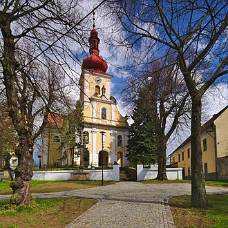
Église Saints-Pierre-et-Paul.


Transports
Par la route, Tištín se trouve à 8 km de Němčice nad Hanou, à 24 km de Prostějov, à 41,5 km d'Olomouc et à 255 km de Prague[5].
Notes et références
- ↑ (cs) Population des communes de la République tchèque au 1er janvier 2025.
- ↑ Distances à vol d'oiseau ou distances orthodromiques.
- ↑ D'après geoportal.gov.cz.
- ↑ (cs) Site municipal : histoire de la commune.
- ↑ Selon viamichelin.fr. Distance correspondant à l'itinéraire le plus court.
Content Disclaimer
Informasi ini disarikan dari Wikipedia dan disajikan kembali untuk tujuan edukasi. Konten tersedia di bawah lisensi CC BY-SA 3.0. Kami tidak bertanggung jawab atas ketidakakuratan data yang bersumber dari kontribusi publik tersebut.
- The information displayed on this website is sourced in part or in whole from Wikipedia and has been adapted for the purpose of restating it. We strive to provide accurate and relevant information, however:
- There is no guarantee of absolute accuracy. Wikipedia is an open, collaborative project that can be edited by anyone, so information is subject to change.
- It is not intended to constitute professional advice. The content displayed is for informational and educational purposes only. For important decisions (e.g., medical, legal, or financial), please consult a professional.
- Content copyright. Wikipedia is licensed under the Creative Commons Attribution-ShareAlike License (CC BY-SA). This means that content may be reused with appropriate attribution and shared under a similar license.
- Responsible use. Any risk arising from the use of information from this website is entirely the responsibility of the user.