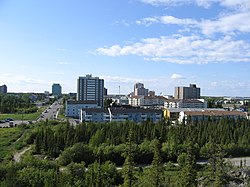
黃刀鎮 (英語:Yellowknife ),也譯作耶洛奈夫 、耶羅納夫 、黃刀市 ,是加拿大 西北地区 的首府。根據2021年加拿大人口普查 ,該市人口有大概20,000人,差不多佔了整個西北地区一半的人口。[ 1] [ 2]
黃刀鎮位處北極圈 以南約400公里,大奴湖 畔。湖的外圍还围着许多湖。黃刀鎮位在北緯62.5度,被北極光橢圓環帶覆蓋,加上地勢平坦,沒有山脈阻隔,極容易見到極光 。
由於近北極圈,黃刀鎮植被較稀疏,主要有樺樹 和雲杉 。另還有不少外露岩石披滿地衣 。
黃刀鎮基本上屬亞寒帶 氣候,全年的降雨量少於300 mm(12英寸),主因是受到西邊的山脈所影響。冬天氣溫可達攝氏零下幾十度,但夏季氣溫則最高曾達32.6 °C(90.7 °F)。
黄刀机场 (1981-2010年平均数据,1942年至今极端数据)
月份
1月
2月
3月
4月
5月
6月
7月
8月
9月
10月
11月
12月
全年
历史最高湿热指数
2.9
6.1
8.9
20.2
25.6
34.0
35.4
34.3
27.2
18.1
6.3
1.6
35.4
历史最高温 °C(°F)
3.4
6.2
9.3
20.4
26.3
31.1
32.5
32.6
26.1
19.0
7.8
2.8
32.6
平均高温 °C(°F)
−21.6
−18.1
−10.8
0.4
9.7
18.1
21.3
18.1
10.4
0.9
−10
−17.8
0.0
日均气温 °C(°F)
−25.6
−22.9
−16.8
−5.3
4.6
13.3
17.0
14.2
7.2
−1.7
−13.7
−21.8
−4.3
平均低温 °C(°F)
−29.5
−27.5
−22.7
−11
−0.5
8.5
12.6
10.2
4.0
−4.2
−17.5
−25.7
−8.6
历史最低温 °C(°F)
−51.2
−51.2
−43.3
−40.6
−22.8
−4.4
0.6
−0.6
−9.7
−28.9
−44.4
−48.3
−51.2
历史最低風寒指數
−64
−61
−56.8
−53.2
−31.8
−11.2
0.0
−4.8
−16.4
−36.3
−54.7
−58.9
−64
平均降水量 mm(英寸)
14.3
14.1
13.9
11.3
18.4
28.9
40.8
39.3
36.3
30.3
24.8
16.2
288.6
平均降雨量 mm(英寸)
0.1
0.0
0.2
2.5
13.8
28.9
40.8
39.2
32.7
12.1
0.3
0.2
170.7
平均降雪量 cm(英寸)
19.7
20.0
18.5
10.3
4.7
0.0
0.0
0.1
3.5
20.9
36.5
23.5
157.6
平均降水天数(≥ 0.2 mm)
10.7
10.0
8.4
5.0
6.6
7.6
9.6
10.5
11.2
13.4
14.4
11.2
118.5
平均降雨天数(≥ 0.2 mm)
0.2
0.1
0.3
1.2
5.3
7.5
9.6
10.4
10.6
5.5
0.6
0.2
51.3
平均降雪天数(≥ 0.2 cm)
11.9
11.0
9.2
4.4
2.1
0.1
0.0
0.1
1.2
10.0
16.0
12.8
78.6
平均相對濕度 (%)
64.6
61.6
54.7
52.5
45.9
45.2
47.9
55.7
64.7
75.2
77.8
69.2
59.6
月均日照時數
50.6
107.3
188.4
276.4
335.7
373.8
358.0
276.2
157.7
65.0
42.7
24.6
2,256.5
可照 百分比
26.8
43.5
51.8
62.2
60.8
63.0
61.2
55.5
40.3
21.0
20.2
15.4
43.5
平均紫外线指数
0
0
1
2
4
5
5
4
2
1
0
0
2
数据来源:Environment Canada [ 3] [ 4] [ 5] [ 6] [ 7]
在寒冷的早晨可能会产生浓重的冰雾
早於加拿大聯邦 成立時,包括黃刀鎮在內的西北地方,已經是加拿大聯邦一部分。當時此一帶已有一些原住民在此居住。後來淘金熱 ,大量加拿大東部的人們前來在西北地區找尋金礦,並相繼發現了黃金。於1936年,第一批居民在黃刀鎮定居。
历史人口统计 年份 人口 ±% 1941 1,410 — 1951 2,724 +93.2% 1956 3,100 +13.8% 1961 3,245 +4.7% 1966 3,741 +15.3% 1971 6,122 +63.6% 1976 8,256 +34.9% 1981 9,483 +14.9% 1986 11,753 +23.9% 1991 15,179 +29.2% 1996 17,275 +13.8% 2001 16,541 −4.2% 2006 18,736 +13.3% 2011 19,234 +2.7% 2016 19,569 +1.7% 2021 20,340 +3.9% 来源:Statistics Canada [ 8] [ 9] [ 10] [ 11] [ 12] [ 13] [ 14] [ 15] [ 16] [ 17] [ 18] [ 19] [ 1]
以採礦為主,亦有為觀賞極光而來的觀光客。
擺放於黃刀鎮 市政府前的麝牛塑像,因英語「Muskox」有伊隆·馬斯克 的「Musk」發音,取名為「Elon Muskox」。 黄金山脉 是黄刀市最著名的酒吧和旅馆野猫咖啡厅 于1937年开业,是黄刀市最古老的餐厅
^ 1.0 1.1 Census Profile, 2021 Census of Population . Statistics Canada. Statistics Canada. [2022-10-16 ] . (原始内容存档 于2022-10-17). ^ Census Profile, 2021 Census of Population . Statistics Canada. Statistics Canada. [2022-10-16 ] . (原始内容存档 于2022-10-18). ^ Yellowknife A . Canadian Climate Normals 1981–2010. Environment Canada . [2015-03-10 ] . Climate ID: 2204100. (原始内容存档 于2022-02-10). ^ Daily Data Report for April 2010 . Canadian Climate Data. Environment Canada . [16 June 2016] . Climate ID: 2204100. (原始内容存档 于2019-04-20). ^ Daily Data Report for June 2013 . Canadian Climate Data. Environment Canada . [16 June 2016] . Climate ID: 2204101. (原始内容存档 于2019-04-20). ^ Daily Data Report for May 2015 . Canadian Climate Data. Environment Canada . [16 June 2016] . Climate ID: 2204101. (原始内容存档 于2019-04-20). ^ Yellowknife, Canada - Monthly weather forecast and Climate data . Weather Atlas. [3 July 2019] . (原始内容存档 于2019-06-28). ^ Ninth Census of Canada, 1951 (PDF) . SP-7 (Population: Unincorporated villages and hamlets). Dominion Bureau of Statistics . March 31, 1954 [February 2, 2022] . (原始内容存档 (PDF) 于2021-11-28). ^ Table 6: Population by census subdivisions, 1901–1961. 1961 Census of Canada (PDF) . Series 1.1: Historical, 1901–1961. I: Population. Ottawa: Dominion Bureau of Statistics . March 8, 1963 [February 1, 2022] . (原始内容存档 (PDF) 于2020-09-02). ^ Table 2: Population of Census Subdivisions, 1921–1971. 1971 Census of Canada (PDF) . Population. Census Subdivisions (Historical). Ottawa: Statistics Canada . July 1973 [February 1, 2022] . (原始内容存档 (PDF) 于2020-08-27). ^ 1976 Census of Canada: Population - Geographic Distributions (PDF) . Statistics Canada . June 1977 [February 1, 2022] . (原始内容存档 (PDF) 于2022-01-14). ^ 1981 Census of Canada: Census subdivisions in decreasing population order (PDF) . Statistics Canada . May 1992 [February 1, 2021] . (原始内容存档 (PDF) 于2022-01-14). ^ 1986 Census: Population - Census Divisions and Census Subdivisions (PDF) . Statistics Canada . September 1987 [February 1, 2022] . (原始内容存档 (PDF) 于2020-05-08). ^ 91 Census: Census Divisions and Census Subdivisions - Population and Dwelling Counts (PDF) . Statistics Canada . April 1992 [February 1, 2022] . (原始内容存档 (PDF) 于2020-05-08). ^ 96 Census: A National Overview - Population and Dwelling Counts (PDF) . Statistics Canada . April 1997 [February 1, 2022] . (原始内容存档 (PDF) 于2021-11-28). ^ Population and Dwelling Counts, for Canada, Provinces and Territories, and Census Subdivisions (Municipalities), 2001 and 1996 Censuses - 100% Data (Northwest Territories) . Statistics Canada . August 15, 2012 [February 1, 2022] . (原始内容存档 于2022-02-03). ^ 2006 Census Corrections and updates . Statistics Canada . June 23, 2009 [February 1, 2022] . (原始内容存档 于2021-12-16). ^ Population and dwelling counts, for Canada, provinces and territories, and census subdivisions (municipalities), 2011 and 2006 censuses (Northwest Territories) . Statistics Canada . July 25, 2021 [February 1, 2022] . (原始内容存档 于2022-02-04). ^ Population and dwelling counts, for Canada, provinces and territories, and census subdivisions (municipalities), 2016 and 2011 censuses – 100% data (Northwest Territories) . Statistics Canada . February 8, 2017 [February 1, 2022] . (原始内容存档 于2022-02-03).


