The 1993 Storm of the Century (also known as the 93 Superstorm, The No Name Storm, or the Great Blizzard of '93/1993) was a cyclonic storm that formed over the Gulf of Mexico on March 12, 1993. The cold weather, heavy snowfall, high winds and storm surges that the storm brought affected a very large area; at its height, it stretched from Canada to Honduras.[1] The cyclone moved through the Gulf of Mexico and then through the eastern United States before moving on to eastern Canada. It eventually dissipated in the North Atlantic Ocean on March 15.
Heavy snow was first reported in highland areas as far south as Alabama and northern Georgia, with Union County, Georgia reporting up to 35 inches (89 cm) of snow. Birmingham, Alabama, reported a rare 13 in (33 cm) of snow.[2][3] The Florida Panhandle reported up to around 6 inches to a foot of snow,[4] with hurricane-force wind gusts and record low barometric pressures. Between Louisiana and Cuba, the hurricane-force winds produced high storm surges across the Big Bend of Florida which, in combination with scattered tornadoes, killed dozens of people.
Record cold temperatures were seen across portions of the Southern United States and Eastern United States in the wake of this storm. In the United States, the storm was responsible for the loss of electric power to more than 10 million households. An estimated 40 percent of the country's population experienced the effects of the storm[5] and it led to a total of 208 fatalities.[1] In all, the storm resulted in 318 deaths, and caused $5.5 billion (1993 USD) in damages.
The greatest recorded snowfall amounts were at Mount Le Conte in Tennessee, where 56 inches (140 cm) of snow fell, and Mount Mitchell in North Carolina, the tallest mountain in eastern North America, where 50 inches (130 cm) were measured to fall and 15-foot (4.6 m) snow drifts were reported.[6]
Meteorological history
Map plotting the storm's track and intensity, according to the Saffir–Simpson scale
A satellite image of the Storm of the Century on March 13, 1993.
A volcanic winter is thought to have started with the 1991 eruption of Mount Pinatubo. The temperature in the stratosphere rose to several degrees higher than normal, due to the absorption of radiation by the aerosol. The stratospheric cloud from the eruption persisted in the atmosphere for three years. The eruption, while not directly responsible, may have played a part in the formation of the 1993 Storm of the Century.[7]
During March 11 and 12, 1993, temperatures over much of the eastern United States began to drop as an arctichigh pressure system built over the Midwestern United States and the Great Plains. Concurrently, an extratropicalarea of low pressure formed over Mexico along a stationary front draped west to east. By the afternoon of March 12, a defined airmass boundary was present along the deepening low. An initial burst of convective precipitation off the southern coast of Texas (facilitated by the transport of tropical moisture into the region) enabled initial intensification of the surface feature on March 12. Supported by a strong split-polar jet stream and a shortwave trough, the nascent system rapidly deepened.[8] The system's central pressure fell to 991 mbar (29.26 inHg) by 00:00 UTC on March 13. A powerful low-level jet over eastern Cuba and the Gulf of Mexico enhanced a cold front extending from the low southward to the Isthmus of Tehuantepec. Furthermore, the subtropical jet stream was displaced unusually far south, reaching into the Pacific Ocean near Central America and extending toward Honduras and Jamaica. Intense ageostrophic flow was noted over the southern United States, with winds flowing perpendicular to isobars over Louisiana.[8]
As the area of low pressure moved through the central Gulf of Mexico, a short wave trough in the northern branch of the jet stream fused with the system in the southern stream, which further strengthened the surface low. A squall line developed along the system's cold front, which moved rapidly across the eastern Gulf of Mexico through Florida and Cuba.[8] The cyclone's center moved into north-west Florida early on the morning of March 13, with a significant storm surge in the northwestern Florida peninsula that drowned several people. This initially caused the storm to be a blizzard but also cyclonic.
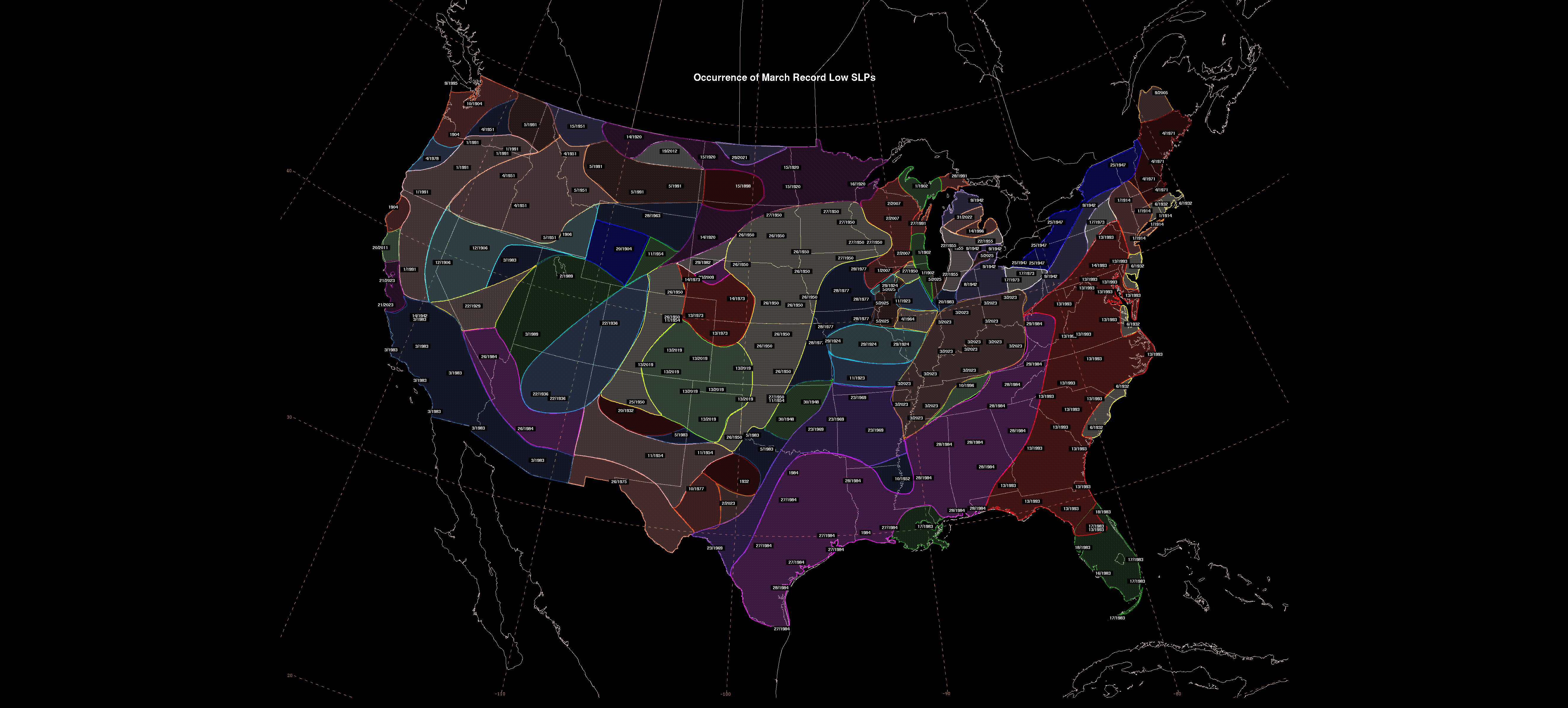
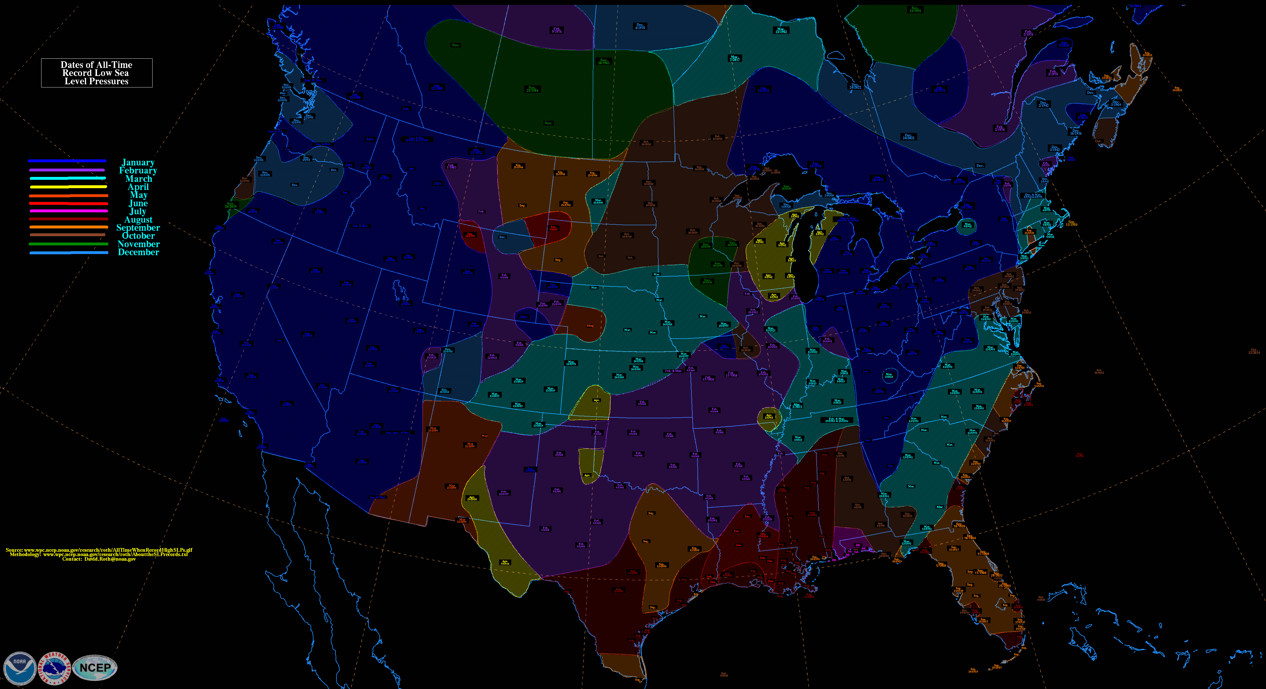
Barometric pressures recorded during the storm were low. Readings of 976.0 millibars (28.82 inHg) were recorded in Tallahassee, Florida, and even lower readings of 960.0 millibars (28.35 inHg) were observed in New England. Low pressure records for March were set in areas of twelve states along the Eastern Seaboard,[9] with all-time low pressure records set between Tallahassee and Washington, D.C.[10] Snow began to spread over the eastern United States, and a large squall line moved from the Gulf of Mexico into Florida and Cuba. The storm system tracked up the East Coast during Saturday and into Canada by early Monday morning. In the storm's wake, unseasonably cold temperatures were recorded over the next two days in the Southeast.
Forecasting
Storm of the Century marked a milestone in the weather forecasting of the United States. By March 8, 1993, several operational numerical weather prediction models and medium-range forecasters at the United States National Weather Service recognized the threat of a significant snowstorm. This marked the first time National Weather Service meteorologists were able to predict accurately a system's severity five days in advance. Official blizzard warnings were issued two days before the storm arrived, as shorter-range models began to confirm the predictions. Forecasters were finally confident enough of the computer-forecast models to support decisions by several northeastern states to declare a state of emergency even before the snow started to fall.[11]
The storm complex was large and widespread, affecting at least 26 US states and much of eastern Canada. It brought in cold air along with heavy precipitation and hurricane-force winds which, ultimately, caused a blizzard over the affected area; this also included thundersnow from Georgia to Pennsylvania and widespread whiteout conditions. Snow flurries were seen in the air as far south as Jacksonville, Florida,[12] and some areas of central Florida received a trace of snow. The storm severely impacted both ground and air travel. Airports were closed all along the eastern seaboard, and flights were cancelled or diverted, thus stranding many passengers along the way. Every airport from Halifax, Nova Scotia, to Tampa was temporarily closed due to the storm. Highways were also closed or restricted all across the affected region, even in states generally well prepared for snow emergencies.[citation needed]
Snowstorm Totals Totals are for the main system only.
Some affected areas in the Appalachian Mountain region saw 5 feet (1.5 m) of snow, and snowdrifts as high as 35 feet (11 m). Mount Le Conte, Tennessee recorded 56" and Mount Mitchell, NC recorded 50 in (130 cm) of snowfall. The volume of the storm's total snowfall was later computed to be 12.91 cubic miles (53.8 km3), an amount which would weigh (depending on the variable density of snow) between 5.4 and 27 billion tons.[citation needed]
The weight of the record snowfalls collapsed several factory roofs in the South; and snowdrifts on the windward sides of buildings caused a few decks with substandard anchoring to fall from homes. Though the storm was forecast to strike the snow-prone Appalachian Mountains, hundreds of people were nonetheless rescued from the Appalachians, many caught completely off guard on the Appalachian Trail or in cabins and lodges in remote locales. Snowdrifts up to 14 feet (4.3 m) were observed at Mount Mitchell. Snowfall totals of between 2 and 3 feet (0.61 and 0.91 m) were widespread across northwestern North Carolina. Boone, North Carolina—in a high-elevation area accustomed to heavy snowfalls—was nonetheless caught off-guard by more than 30 inches (76 cm) of snow and 24 hours of temperatures below 11 °F (−12 °C). Boone's Appalachian State University closed that week, for the first time in its history. Stranded motorists at Deep Gap broke into Parkway Elementary School to survive, and National Guard helicopters dropped hay in fields to keep livestock from starving in northern N.C. mountain counties.[citation needed]
In Virginia, the LancerLot sports arena in Vinton collapsed due to the weight of the record snowfall, forcing the Virginia Lancers of the ECHL to relocate to nearby Roanoke and become the Roanoke Express. Also collapsing were the roofs of a Lowe's store in Christiansburg and the Dedmon Center, at Radford University. Thousands of travelers were stranded along interstate highways in Southwest Virginia.[23]
Electricity was not restored to many isolated rural areas for up to three weeks, with power outages occurring all over the east. Nearly 60,000 lightning strikes were recorded as the storm swept over the country for a total of 72 hours. As one of the most powerful, complex storms in recent history, this storm was described as the "Storm of the Century" by many of the areas affected.[citation needed]
A hockey game hosted by the Philadelphia Flyers against the Los Angeles Kings was postponed due to a large window breaking from wind gusts just before the end of the first period.[24]
Gulf of Mexico
The United States Coast Guard dealt with "absolutely incredible, unbelievable" conditions within the Gulf of Mexico. The 200-foot (61 m) freighter Fantastico sank 70 miles (110 km) off Ft. Myers, Florida, and seven of her crew died when a Coast Guard helicopter was forced back to base due to low fuel levels after rescuing three of her crew. The 147-foot (45 m) freighter Miss Beholden ran aground on a coral reef 10 miles (16 km) from Key West, Florida. Several other smaller vessels sank in the rough seas. In all, the Coast Guard rescued 235 people from over 100 boats across the Gulf of Mexico during the tempest.[25]
Florida
The Derecho moves into the Florida coast during the overnight hours of March 13, 1993NOAA estimate of storm surges along Florida's Gulf Coast, March 13, 1993.[26]
Besides producing record-low barometric pressure across a swath of the Southeast and Mid-Atlantic states, and contributing to one of the nation's biggest snowstorms, the low produced a potent squall line ahead of its cold front. The squall line produced a serial derecho as it moved into Florida and Cuba shortly after midnight on March 13. Straight-line winds gusted above 100 miles per hour (87 kn; 160 km/h) at many locations in Florida as the squall line moved through. A substantial tree fall was seen statewide from this system. The supercells in the derecho produced eleven tornadoes. The first tornado was an F2 that touched down in Chiefland at 04:38 UTC on March 13, damaging several mobile homes and downing trees and power lines. Three people were killed and seven people sustained injures. Around the same time, an F1 tornado was spawned near Crystal River. After moving eastward into the town, the twister damaged 15 homes, several of them severely. A total of three people were injured. The next tornado was a waterspout that moved ashore over Treasure Island around 05:00 UTC. Rated F0, the tornado deroofed one home, damaged several others, and impacted a few boats.[27]
Around 05:04 UTC, an F0 tornado was reported in New Port Richey, damaging several homes and injuring 11 people. About 16 minutes later, an F2 tornado formed to the southwest of Ocala. Many trees fell and several storage buildings and a warehouse suffered extensive damage, while one hangar was destroyed and two others received major damage at the Ocala International Airport. At 05:20 UTC, approximately the same time as the Ocala tornado, another twister – rated F1 – touched down near LaCrosse. Several trees and power lines were downed and a few homes were destroyed, one from a propane explosion. One person was killed and four others received injuries. About 10 minutes later, another F2 twister was spawned near Howey-in-the-Hills. It moved through Mount Dora, destroying 13 homes, substantially damaging 80 homes, and inflicting minor damage on 266 homes. One person, a 5-month-old baby, was killed, while two others were injured.[27]
At 05:30 UTC, a waterspout-turned F0 tornado tossed a 23 ft (7.0 m) sailboat about 300 ft (91 m) at the Davis Islands yacht club in Tampa, while five other boats broke loose from their cradles and twelve were smashed into the seawall. About 30 minutes later,
an F1 tornado formed in Jacksonville, demolishing four dwellings and damaging sixteen others.[27] Also at 06:00 UTC, an F0 tornado spawned near Bartow snapped a few trees and damaged a few doors. The eleventh and final tornado developed in Jacksonville at 06:10 UTC. The twister damaged a few trees near the Jacksonville International Airport. At the airport itself, the tornado damaged several jetways and service vehicles, while a Boeing 737 was pushed about 40 ft (12 m).[27]
Storm surges in those areas reached up to 12 feet (3.7 m),[26] higher than many hurricanes. With little advance warning of incoming severe conditions, some coastal residents were awakened in the early morning of March 13 by the waters of the Gulf of Mexico rushing into their homes.[28] More people died from drowning in this storm than during Hurricanes Hugo and Andrew combined.[5] Overall, the storm's surge, winds, and tornadoes damaged or destroyed 18,000 homes.[29] A total of 47 people died in Florida due to this storm.[4]
Despite all the rainfall and tornadoes, lots of snow also dropped in the Panhandle regions of Florida. Areas saw snow of up to 1 foot near the coast and inland. In Tallahassee, around 1 to 2 inches of snow were dropped to the ground. In Jacksonville and Fernandina beach, traces of snow were seen in the air. Very cold temperatures were also seen in the state. Snow was seen as far south as Tampa Bay in central Florida. Tallahassee's lowest temperature was 17 degrees F (-8 degrees C) On March 13, Orlando saw 26 degrees F (-3 degrees C), and Miami saw 39 degrees F (4 degrees C ) That same day. In Orlando, there were mixed precipitations with rain, sleet and snow combined. Miami saw near record cold temperatures for the month of March, making it a very rare phenomenon for Florida. Florida is usually mild all year round so it was rare.
Cuba
In Cuba, wind gusts reached 100 mph (160 km/h) in the Havana area. A survey conducted by a research team from the Institute of Meteorology of Cuba suggests that the maximum winds could have been as high as 130 mph (210 km/h). It is the most damaging squall line ever recorded in Cuba.
There was widespread and significant damage in Cuba, with damage estimated as intense as F2.[8] The squall line finally moved out of Cuba near sunrise, leaving 10 deaths and US$1 billion in damage on the island.
North Atlantic
The cargo ship Gold Bond Conveyor en route from Halifax, Nova Scotia, Canada to Tampa, Florida foundered in the Atlantic Ocean 60 nautical miles (110 kilometres) SE of Sable Island, Nova Scotia with the loss of all 33 crew.[30] It is thought that water entered the hold where gypsum ore was being stored and caused the rock to shift and harden. This instability compounded with winds of 90 miles per hour (140 km/h) and 100-foot (30 m) waves led to her sinking. The Liberian-flagged ship was owned by Skaarup Shipping Corp., of Greenwich, Connecticut, and under charter to National Gypsum Co., a U.S. company. The ship had previously survived the Perfect Storm of 1991 two years earlier.[31]
Untuk sosiolog, lihat Robert King Merton. Robert C. MertonLahir31 Juli 1944 (umur 79)New York City, New York, Amerika SerikatKebangsaanAmerika SerikatAlmamaterUniversitas ColumbiaCaltechMITDikenal atasBlack–Scholes model ICAPM Merton's portfolio problemMerton ModelModel Jarrow-TurnbullManajemen kapital jangka panjangPenghargaanPenghargaan Nobel dalam Ekonomi (1997) Lifetime Achievement in Mathematical Finance (1999)Karier ilmiahBidangFinansial, EkonomiPembimbing doktoralPaul Samuelson Rob…
Peta infrastruktur dan tata guna lahan di Komune Belmont-sur-Buttant. = Kawasan perkotaan = Lahan subur = Padang rumput = Lahan pertanaman campuran = Hutan = Vegetasi perdu = Lahan basah = Anak sungaiBelmont-sur-Buttant merupakan sebuah komune di departemen Vosges yang terletak pada sebelah timur laut Prancis. Lihat pula Komune di departemen Vosges Referensi INSEE lbsKomune di departemen Vosges Les Ableuvenettes Ahéville Aingeville Ainvelle Allarm…
Artikel ini perlu dikembangkan agar dapat memenuhi kriteria sebagai entri Wikipedia.Bantulah untuk mengembangkan artikel ini. Jika tidak dikembangkan, artikel ini akan dihapus. Hapagfly Boeing 737-800 Hapagfly Airbus A310 Hapagfly adalah nama maskapai penerbangan Jerman. Kode IATA HF dan kode ICAO HLF. lbsAnggota European Low Fares Airline Association (ELFAA) easyJet · Flybe · MyAir · Norwegian Air Shuttle · Ryanair · SkyEurope · …
National Route 3国道3号 (Kokudō San-gōcode: ja is deprecated )Informasi rutePanjang:392.1 km[1] (243,6 mi)Persimpangan besarUjung Selatan: Rute 10 di Kagoshima, KagoshimaUjung Utara: Rute 2 in Moji-ku, KitakyushuSistem jalan bebas hambatanJalan Raya Nasional di JepangJalan Bebas Hambatan di Jepang Jalan Raya Nasional Jepang Rute 3 adalah jalan raya nasional yang menghubungkan Kagoshima dan Moji-ku, Kitakyushu. Data Rute Panjang: 392,1 km Awal: Moji-ku, Kitakyūshū (B…
Johann Baptist van Helmont. Jan Baptista (juga dieja Jean-Baptiste, Johannes Baptista, Joan Baptista, dll) van Helmont (Brusel, 1579 - 1644) ialah seorang dokter Belgia. Helmont menjadi dokter pada tahun 1599 dan pada tahun 1605 ia tinggal di Vilvoorde dekat Brusel. Helmont adalah seorang peneliti alam pertama di zamannya; ia menemukan asam karbon, yang manjadi otoritas dasar anatomi dan membangun keuntungan penting untuk praktik dokter, memberikan semua melalui perlawanan terbuka pada metode pe…
Arrone kota kecilcommune di Italia Tempat categoria:Articles mancats de coordenades Negara berdaulatItaliaRegion di ItaliaUmbraProvinsi di ItaliaProvinsi Terni NegaraItalia Ibu kotaArrone PendudukTotal2.555 (2023 )GeografiLuas wilayah41,04 km² [convert: unit tak dikenal]Ketinggian239 m Berbatasan denganFerentillo Labro (en) Montefranco Morro Reatino (en) Polino Terni SejarahSanto pelindungYohanes Pembaptis Organisasi politikAnggota dariThe most beautiful villages in Italy (en) Inform…
Galaktion Yeliseyevich AlpaidzeNama aslibahasa Georgia: გალაქტიონ ალფაიძეRusia: Галактио́н Елисе́евич Алпаи́дзеcode: ru is deprecated Lahir(1916-11-07)7 November 1916Kursebi, Kekaisaran Rusia(sekarang di Distrik Tqibuli, Georgia)Meninggal2 Mei 2006(2006-05-02) (umur 89)Moskwa, Federasi RusiaDikebumikanPemakaman Troyekurovskoye, MoskwaPengabdian Uni SovietDinas/cabang Tentara Merah / Angkatan Darat Uni SovietLama dinas1938…
Serbuan Yuan-Mongol ke JawaArmada Kubilai Khan melewati kepulauan Indonesia, ilustrasi oleh Sir Henry Yule (1871)Tanggal22 Januari 1293–awal Agustus 1293[1] (8 bulan)LokasiJawa Timur, tepatnya di kota Daha dan Majapahit. Sepanjang sungai Kali Mas/Brantas.Hasil Runtuhnya Kerajaan Kadiri, kemenangan Raden Wijaya dan didirikannya MajapahitPihak terlibat 大元 Kekaisaran Tiongkok-Mongol ( Dinasti Yuan) Kerajaan SinghasariMajapahit Kerajaan KadiriTokoh dan pemimpin Kubilai Khan (komandan t…
Betel (bahasa Ugarit: bt il, artinya rumah El atau rumah Allah,[1] Ibrani: בֵּית אֵלcode: he is deprecated , Beth El, Beth-El, atau Beit El; Greek: Βαιθηλcode: el is deprecated ; Latin: Bethelcode: la is deprecated ; Inggris: Bethelcode: en is deprecated ) adalah kota perbatasan yang menurut Alkitab Ibrani dan Perjanjian Lama di Alkitab Kristen terletak di antara wilayah suku Benyamin dan Efraim. Eusebius dari Kaisarea dan Hieronimus pada zaman mereka menggambarkannya sebag…
Artikel ini memiliki beberapa masalah. Tolong bantu memperbaikinya atau diskusikan masalah-masalah ini di halaman pembicaraannya. (Pelajari bagaimana dan kapan saat yang tepat untuk menghapus templat pesan ini) Kontributor utama artikel ini tampaknya memiliki hubungan dekat dengan subjek. Artikel ini mungkin memerlukan perapian untuk mematuhi kebijakan konten Wikipedia, terutama dalam hal sudut pandang netral. Silakan dibahas lebih lanjut di halaman pembicaraan artikel ini. (November 2023) (Pela…
Untuk kegunaan lain, lihat Hannibal (disambiguasi). Hannibal, putra dari Hamilcar BarcaPengabdianKartagoPangkatJenderalPerang/pertempuranPerang Punisia Kedua: Pertempuran Danau Trasimene, Pertempuran Trebia, Pertempuran Cannae, Pertempuran Zama Hannibal (bahasa Punik: 𐤇𐤍𐤁𐤏𐤋, translit. Ḥannībaʿl; 247 – antara 183 hingga 181 SM) adalah seorang pemimpin militer di Perang Punisia Kedua dan seorang politisi, kelak dia juga bekerja di profesi yang lain, dia disebut-sebut …
Group of national and state parks in northwestern California, United States Redwood National and State ParksIUCN category V (protected landscape/seascape)A forest of coast redwoods in fogShow map of CaliforniaShow map of the United StatesLocationHumboldt County & Del Norte County, California, USNearest cityCrescent CityCoordinates41°18′N 124°00′W / 41.3°N 124°W / 41.3; -124Area139,091 acres (562.88 km2)[1]EstablishedOctober 2, 1968Visitors458…
Skeletal formula CC-1088 is a thalidomide analogue inhibitor of phosphodiesterase 4 that was being developed up to 2005 by Celgene Corp., for treating of inflammatory diseases and myelodysplastic syndromes.[1] Apremilast (CC-10004) was found to be a preferable.[2] See also Apremilast Development of analogs of thalidomide References ^ K. Dredge (May 2005). CC-1088 Celgene. Current Opinion in Investigational Drugs. 6 (5): 513–7. PMID 15912966. ^ Molostvov G, Morris A, Rose P…
American politician John W. Haigis, Sr.Treasurer and Receiver General of MassachusettsIn office1928–1930GovernorAlvan T. FullerFrank G. AllenPreceded byWilliam S. YoungmanSucceeded byCharles F. HurleyMassachusetts State SenateIn office1923–1927Massachusetts State SenateIn office1913–1915Massachusetts House of Representatives3rd Franklin District[1]In office1909–1913Town of Montague, MassachusettsBoard of Water CommissionersIn office1910–1915Town of Montague, MassachusettsAssess…
Baye, Marne Koordinat: 48°51′20″N 3°45′54″E / 48.8556°N 3.765°E / 48.8556; 3.765NegaraPrancisArondisemenÉpernayKantonMontmort-LucyAntarkomuneCommunauté de communes de la Brie des ÉtangsKode INSEE/pos51042 / Untuk pengertian lain, lihat Baye. Baye adalah komune di departemen Marne, Champagne-Ardenne, Prancis. Demografi Populasi historis Tahun JumlahPend. ±% 482 — 393 — Sumber: …
Medical specialty For the scientific journal, see Urology (journal). This article needs additional citations for verification. Please help improve this article by adding citations to reliable sources. Unsourced material may be challenged and removed.Find sources: Urology – news · newspapers · books · scholar · JSTOR (September 2009) (Learn how and when to remove this template message) UrologistUrologist performing a TURPOccupationOccupation typeSpecialtyA…
Wilayah Ilocos di peta Filipina Wilayah Ilocos atau Wilayah I adalah wilayah pembagian administratif yang terletak di barat laut Filipina. Wilayah ini terbagi ke dalam 4 provinsi: Ilocos Norte, Ilocos Sur, La Union dan Pangasinan. Pusat wilayahnya terletak di San Fernando City, La Union. Pranala luar Executive Order No. 561: FORMATION OF THE SUPER REGIONS AND MANDATE OF THE SUPERREGIONAL DEVELOPMENT CHAMPIONS Diarsipkan 2008-09-17 di Wayback Machine. North Luzon Super Region: Potentials Diarsipk…
Mountain biking trail outside Moab, Utah Mountain bikers on the Slickrock Trail, September 2004 The Slickrock Trail, is a popular mountain biking destination in Grand County, Utah, United States, a few miles northeast of the city of Moab.[1][2][3][4][5] This 10.5-mile (16.9 km) trail[6][Note 1] takes riders over a landscape of petrified sand dunes and the eroded remnants of ancient sea beds. Mountain bikers rate the Slickrock Trail as …
Karim Adeyemi Adeyemi, 2022Informasi pribadiNama lengkap Karim-David Adeyemi[1]Tanggal lahir 18 Januari 2002 (umur 22)Tempat lahir Munich, JermanTinggi 180 m (590 ft 7 in)[2]Posisi bermain PenyerangInformasi klubKlub saat ini Borussia DortmundNomor 27Karier junior2008–2010 TSV Forstenried2010–2012 Bayern Munich2012–2018 SpVgg Unterhaching2018–2020 Red Bull SalzburgKarier senior*Tahun Tim Tampil (Gol)2018–2022 Red Bull Salzburg 68 (27)2018–2020 → …


")


