Share to: share facebook share twitter share wa share telegram print page

Cibola County, New Mexico

Cibola County
Cibola County Courthouse in Grants
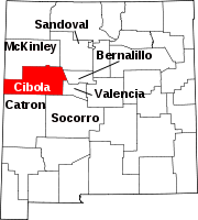
Map of New Mexico highlighting Cibola County
Location within the U.S. state of New Mexico
Map of the United States highlighting New Mexico
New Mexico's location within the U.S.
Coordinates: 34°55′N 107°59′W / 34.92°N 107.99°W / 34.92; -107.99
Country United States
State New Mexico
FoundedJune 19, 1981
Named forMythical Seven Cities of Cibola
SeatGrants
Largest cityGrants
Area
 • Total4,542 sq mi (11,760 km2)
 • Land4,539 sq mi (11,760 km2)
 • Water2.3 sq mi (6 km2)  0.05%
Population
 (2020)
 • Total27,172
 • Density6.0/sq mi (2.3/km2)
Time zoneUTC−7 (Mountain)
 • Summer (DST)UTC−6 (MDT)
Congressional district2nd
Websitewww.co.cibola.nm.us

Cibola County is a county in the U.S. state of New Mexico. As of the 2020 census, the population was 27,172.[1] Its county seat is Grants.[2] It is New Mexico's youngest county, and the third youngest county in the United States, created on June 19, 1981, from the westernmost four-fifths of the formerly much larger Valencia County.

Cibola County comprises the Grants, New Mexico Micropolitan Statistical Area. The county is a rich mining area with numerous Uranium mines.

Geography

Ventana Arch in El Malpais National Monument

According to the U.S. Census Bureau, the county has an area of 4,542 square miles (11,760 km2), of which 4,539 square miles (11,760 km2) is land and 2.3 square miles (6.0 km2) (0.05%) is water.[3]

Adjacent counties

National protected areas

Demographics

Historical population
CensusPop.Note
199023,794
200025,5957.6%
201027,2136.3%
202027,172−0.2%
U.S. Decennial Census[4]
1790-1960[5] 1900-1990[6]
1990-2000[7] 2010[8]

2000 census

As of the 2000 census,[9] there were 25,595 people, 8,327 households, and 6,278 families living in the county. The population density was 6 people per square mile (2.3 people/km2). There were 10,328 housing units at an average density of 2 units per square mile (0.77/km2). The racial makeup of the county was 39.61% White, 0.96% Black or African American, 40.32% Native American, 0.38% Asian, 0.05% Pacific Islander, 15.44% from other races, and 3.24% from two or more races. 33.42% of the population were Hispanic or Latino of any race.

There were 8,327 households, out of which 38.00% had children under the age of 18 living with them, 50.60% were married couples living together, 18.30% had a female householder with no husband present, and 24.60% were non-families. 21.10% of all households were made up of individuals, and 7.30% had someone living alone who was 65 years of age or older. The average household size was 2.95 and the average family size was 3.41.

In the county, the population was spread out, with 30.70% under the age of 18, 9.60% from 18 to 24, 27.50% from 25 to 44, 21.50% from 45 to 64, and 10.70% who were 65 years of age or older. The median age was 33 years. For every 100 females there were 95.50 males. For every 100 females age 18 and over, there were 92.20 males.

The median income for a household in the county was $27,774, and the median income for a family was $30,714. Males had a median income of $27,652 versus $20,078 for females. The per capita income for the county was $11,731. About 21.50% of families and 24.80% of the population were below the poverty line, including 32.00% of those under age 18 and 17.70% of those age 65 or over.

2010 census

As of the 2010 census, there were 27,213 people, 8,860 households, and 6,274 families living in the county.[10] The population density was 6.0 inhabitants per square mile (2.3 inhabitants/km2). There were 11,101 housing units at an average density of 2.4 units per square mile (0.93 units/km2).[11] The racial makeup of the county was 41.8% white, 41.0% American Indian, 1.0% black or African American, 0.5% Asian, 0.1% Pacific islander, 12.4% from other races, and 3.1% from two or more races. Those of Hispanic or Latino origin made up 36.5% of the population.[10] In terms of ancestry, 5.4% were Irish, and 1.5% were American.[12]

Of the 8,860 households, 38.0% had children under the age of 18 living with them, 41.1% were married couples living together, 20.8% had a female householder with no husband present, 29.2% were non-families, and 24.9% of all households were made up of individuals. The average household size was 2.79 and the average family size was 3.30. The median age was 36.6 years.[10]

The median income for a household in the county was $37,361 and the median income for a family was $41,187. Males had a median income of $36,027 versus $25,318 for females. The per capita income for the county was $14,712. About 20.1% of families and 24.0% of the population were below the poverty line, including 32.7% of those under age 18 and 14.3% of those age 65 or over.[13]

Education

The Mining Museum in Grants

School districts serving portions of the county include:[14]

All public schools in the county are operated by Grants/Cibola County Schools; the Quemado and Zuni facilities are in other counties.

Due to an agreement between Cibola County and McKinley County, residents of the Ramah Navajo Indian Reservation are bussed to schools in Ramah in McKinley County (including Ramah Middle/High School) even though they are physically in Cibola County, due to the long distance to the nearest Cibola County schools from the reservation.[15]

Corrections

Cibola County is home to three prisons:

In November 2018, following a private autopsy, a unit of the Cibola County Correctional Center (CCCC) was named in the abuse and wrongful death on May 25, 2018, of Roxsana Hernández Rodríguez. Rodríguez was a 33yo transgender immigrant from Honduras. The CCCC is operated under contract by CoreCivic.[19][20]

Politics

United States presidential election results for Cibola County, New Mexico[21]
Year Republican Democratic Third party
No.  % No.  % No.  %
2020 3,975 44.65% 4,745 53.30% 183 2.06%
2016 3,195 39.63% 3,741 46.40% 1,127 13.98%
2012 2,998 36.37% 4,961 60.18% 284 3.45%
2008 3,131 34.42% 5,827 64.05% 139 1.53%
2004 3,477 46.44% 3,913 52.26% 97 1.30%
2000 2,752 38.83% 4,127 58.23% 209 2.95%
1996 2,245 32.63% 4,030 58.58% 605 8.79%
1992 2,051 32.64% 3,334 53.06% 899 14.31%
1988 2,640 43.02% 3,458 56.35% 39 0.64%
1984 3,578 53.09% 3,140 46.59% 22 0.33%

Cibola County tends to support the Democratic Party. Only once in its history (1984) has it voted for a Republican presidential nominee, when Ronald Reagan won the county in his 49-state landslide.

At the state level, the only time it has voted for a Republican nominee for Governor was 2014, when Susana Martinez carried all but five counties in her reelection bid.

Communities

Acoma Pueblo, "Sky City", 2008
South side of Inscription Rock, El Morro National Monument. Photo by Timothy H. O'Sullivan, 1873.

City

Village

Census-designated places

There are 32 Census Designated Places contained within the county, largely designated in 1980.

Unincorporated communities

Ghost towns

See also

References

Specific
  1. ^ "Cibola County, New Mexico". United States Census Bureau. Retrieved July 1, 2023.
  2. ^ "Find a County". National Association of Counties. Archived from the original on May 31, 2011. Retrieved June 7, 2011.
  3. ^ "2010 Census Gazetteer Files". United States Census Bureau. August 22, 2012. Archived from the original on January 1, 2015. Retrieved January 1, 2015.
  4. ^ "U.S. Decennial Census". United States Census Bureau. Retrieved January 1, 2015.
  5. ^ "Historical Census Browser". University of Virginia Library. Archived from the original on August 11, 2012. Retrieved January 1, 2015.
  6. ^ "Population of Counties by Decennial Census: 1900 to 1990". United States Census Bureau. Retrieved January 1, 2015.
  7. ^ "Census 2000 PHC-T-4. Ranking Tables for Counties: 1990 and 2000" (PDF). United States Census Bureau. Archived (PDF) from the original on March 27, 2010. Retrieved January 1, 2015.
  8. ^ "State & County QuickFacts". United States Census Bureau. Archived from the original on June 6, 2011. Retrieved September 27, 2013.
  9. ^ "U.S. Census website". United States Census Bureau. Retrieved January 31, 2008.
  10. ^ a b c "DP-1 Profile of General Population and Housing Characteristics: 2010 Demographic Profile Data". United States Census Bureau. Archived from the original on February 13, 2020. Retrieved January 24, 2016.
  11. ^ "Population, Housing Units, Area, and Density: 2010 - County". United States Census Bureau. Archived from the original on February 13, 2020. Retrieved January 24, 2016.
  12. ^ "DP02 SELECTED SOCIAL CHARACTERISTICS IN THE UNITED STATES – 2006-2010 American Community Survey 5-Year Estimates". United States Census Bureau. Archived from the original on February 13, 2020. Retrieved January 24, 2016.
  13. ^ "DP03 SELECTED ECONOMIC CHARACTERISTICS – 2006-2010 American Community Survey 5-Year Estimates". United States Census Bureau. Archived from the original on February 13, 2020. Retrieved January 24, 2016.
  14. ^ "2020 CENSUS - SCHOOL DISTRICT REFERENCE MAP: Cibola County, NM" (PDF). U.S. Census Bureau. Archived (PDF) from the original on July 21, 2021. Retrieved July 12, 2022. - Text list
  15. ^ Linthicum, Leslie (March 6, 1995). "Navajos Say County Is Stealing Students". Albuquerque Journal. Albuquerque, New Mexico. pp. A1, A3. - Clipping of first and of second page at Newspapers.com. Page 2 text details: A, B, and C
  16. ^ CoreCivic. "CoreCivic: Better the Public Good". cca.com. Retrieved April 1, 2018.
  17. ^ "Cibola County Correctional Center". Corrections Corporation of America. Retrieved August 26, 2016.
  18. ^ "Western New Mexico Correctional Facility". New Mexico Corrections Department. Retrieved August 26, 2016.
  19. ^ Bixby, Scott; Betsy Woodruff (November 26, 2018). "Trans Woman Was Beaten in ICE Custody Before Death, Autopsy Finds". The Daily Beast. The Daily Beast Company. Retrieved November 27, 2018.
  20. ^ admin (November 26, 2018). "Justice for Roxsana: Announcing Legal Action To Hold Government Accountable for Transgender Asylum-Seeker's Death". TransGender Law Center. Retrieved November 27, 2018.
  21. ^ Leip, David. "Dave Leip's Atlas of U.S. Presidential Elections". uselectionatlas.org. Retrieved April 1, 2018.
General

Further reading

  • Baldwin, J.A. and D.R. Rankin. (1995). Hydrogeology of Cibola County, New Mexico [Water-Resources Investigations Report 94-4178]. Albuquerque: U.S. Department of the Interior, U.S. Geological Survey.
  • Maxwell, C.H. (1989). Mineral resources of the Petaca Pinta wilderness study area, Cibola County, New Mexico [U.S. Geological Survey Bulletin 1734-H]. Denver: U.S. Department of the Interior, U.S. Geological Survey.

External links

Media related to Cibola County, New Mexico at Wikimedia Commons

34°55′N 107°59′W / 34.92°N 107.99°W / 34.92; -107.99

Read more information:

Questa voce o sezione sull'argomento storia della Germania non cita le fonti necessarie o quelle presenti sono insufficienti. Puoi migliorare questa voce aggiungendo citazioni da fonti attendibili secondo le linee guida sull'uso delle fonti. Impero romano-germanico intorno al 1690 La storia della Germania è caratterizzata da una grande complessità, ed è strettamente dipendente dalla definizione politico-geografica che si vuole dare al termine stesso di Germania. Per Gaio Giulio Cesare tu…

Teluk Tokyo東京湾Tōkyō-wanFoto Landsat Teluk TokyoWilayah Teluk Tokyo dalam pengertian yang sempit (merah jambu) dan pengertian yang luas (merah jambu dan biru).LetakHonshu, JepangKoordinat35°25′N 139°47′E / 35.417°N 139.783°E / 35.417; 139.783Asal sungaiSungai AraSungai EdoSungai ObitsuSungai YoroAsal aliran lautSamudera PasifikTerletak di negaraJepangArea permukaan1500 kilometer persegiKedalaman rata-rata40 meterKedalaman maksimal70 meterKepulauanSarushima …

Questa voce sull'argomento centri abitati dell'Ohio è solo un abbozzo. Contribuisci a migliorarla secondo le convenzioni di Wikipedia. Segui i suggerimenti del progetto di riferimento. WarrencityWarren – VedutaWomens Park LocalizzazioneStato Stati Uniti Stato federato Ohio ConteaTrumbull AmministrazioneSindacoMichael J. O'Brien TerritorioCoordinate41°14′18″N 80°48′52″W / 41.238333°N 80.814444°W41.238333; -80.814444 (Warren)Coordinate: 41°14′18…

Artikel ini sebatang kara, artinya tidak ada artikel lain yang memiliki pranala balik ke halaman ini.Bantulah menambah pranala ke artikel ini dari artikel yang berhubungan atau coba peralatan pencari pranala.Tag ini diberikan pada November 2022. Artikel ini sebatang kara, artinya tidak ada artikel lain yang memiliki pranala balik ke halaman ini.Bantulah menambah pranala ke artikel ini dari artikel yang berhubungan atau coba peralatan pencari pranala.Tag ini diberikan pada Oktober 2022. Francis M…

Gelagah Kaso, Saccharum spontaneumdari Cihideung Ilir, Ciampea, Bogor Klasifikasi ilmiah Kerajaan: Plantae (tanpa takson): Angiospermae (tanpa takson): Monokotil (tanpa takson): Commelinids Ordo: Poales Famili: Poaceae Subfamili: Arundinoideae Tribus: Arundineae Genus: Saccharum Spesies: S. spontaneum Nama binomial Saccharum spontaneumL.[1] Sinonim Imperata klaga Jungh. sinonim selengkapnya pada The Plant List[2] Gelagah (Saccharum spontaneum)[3] atau Tibarau adalah …

Keean JohnsonLahir25 Oktober 1996 (umur 27)Colorado, Amerika SerikatPekerjaanAktorTahun aktif2002–sekarang Keean Johnson (lahir 25 Oktober 1996)[1] adalah aktor dan penari asal Amerika Serikat. Lahir di Colorado,[2] ia memainkan salah satu peran utama, Hugo, dalam film Alita: Battle Angel. Di televisi, ia telah berperan sebagai Adam Freeman di acara Spooksville dan Colt Wheeler di Nashville, serta memiliki peran berulang di The Fosters dan Guidance.[3][4&#…

Promozione1966-1967 Competizione Promozione Sport Calcio Edizione 8ª Organizzatore FIGC - LNDComitato Regionale Campania Luogo  Italia Cronologia della competizione 1965-1966 1967-1968 Manuale Voce principale: Prima Categoria 1966-1967. Il campionato di calcio di Prima Categoria 1966-1967 è stato il V livello del campionato italiano. A carattere regionale, fu l'ottavo campionato dilettantistico con questo nome dopo la riforma voluta da Zauli del 1958. Questi sono i gironi organizzati dall…

Giri MulyaDesaNegara IndonesiaProvinsiKalimantan SelatanKabupatenTanah BumbuKecamatanKuranjiKode pos72272Kode Kemendagri63.10.10.2001 Luas200 km²Jumlah penduduk2086 jiwaKepadatan10.43 jiwa/km² Giri Mulya adalah salah satu desa di wilayah kecamatan Kuranji, Kabupaten Tanah Bumbu, Provinsi Kalimantan Selatan, Indonesia. Giri Mulya merupakan Kota Kecamatan dari Kecamatan Kuranji, desa ini merupakan desa dengan fasilitas paling lengkap sejak awal terbentuknya, dimana sejak awal pembentukannya…

Patung Hanoman, dengan gunung Dronagiri di tangan kanannya dan gada di tangan kirinya. Gada (Bahasa sansekerta: गदा gadā, Kannada: ಗದೆ, Telugu: గద, Tamil: gadai, Melayu: gedak, Tagalog Lama: batuta) adalah semacam martil atau cokmar tumpul yang berasal dari India. Terbuat dari kayu atau logam, gada pada dasarnya adalah kepala bundar yang dipasang pada sebuah batang, dengan duri di atasnya. Di luar India, gada juga diadopsi sebagai senjata di Asia Tenggara, dimana gada digunakan …

هذه قائمة مرتبة من الثقوب السوداء الأكبر حجما المعروفة (و المرشحة المحتملة ) لأن تكون الأكبر، وتقاس بوحدة كتلة شمسية (M☉)، أو كتلة الشمس تساوي (حوالي 2 × 1030 كجم). مقدمة المجرات التي توجد فيها الثقوب السوداء كبيرة الحجم قليلة وتشمل مجرة درب التبانة، مجرات المجموعة المحلية وعدد ق…

يفتقر محتوى هذه المقالة إلى الاستشهاد بمصادر. فضلاً، ساهم في تطوير هذه المقالة من خلال إضافة مصادر موثوق بها. أي معلومات غير موثقة يمكن التشكيك بها وإزالتها. (نوفمبر 2019) الدوري الفلسطيني الممتاز لقطاع غزة الموسم 2018–19 البلد  فلسطين النسخة 13 عدد الفرق 12 الفترة 8 سبتمبر 2018 - 10 …

Oʻzbekiston Respublikasining Davlat MadhiyasiLagu kebangsaan  UzbekistanPenulis lirikAbdulla Oripov, 1992KomponisMutal Burhanov, 1947Penggunaan1992Sampel audioLagu Kebangsaan Uzbekistanberkasbantuan Sampel audioLagu kebangsaan Uzbekistanberkasbantuan Dengan vokal Lagu Kebangsaan Republik Uzbekistan (bahasa Uzbek: O‘zbekiston Respublikasining Davlat Madhiyasi) terbentuk ketika Uzbekistan masih berupa republik bagian dari Uni Soviet. Setelah kemerdekaan pada tahun 1991, lagu kebangsaan yan…

Badan Regulasi Telekomunikasi Indonesia BRTIGambaran umumSingkatanBRTIDidirikan8 September 2000Dasar hukum pendirianUndang-Undang Nomor 36 Tahun 1999Dibubarkan26 November 2020Dasar hukum pembubaranPeraturan Presiden Nomor 112 Tahun 2020Kantor pusatMenara Ravindo, Kav.75 Lantai 11, Jl. Kebon Sirih, Daerah Khusus Ibukota Jakarta 10340Situs webhttp://www.brti.or.idSunting kotak info • L • BBantuan penggunaan templat ini Badan Regulasi Telekomunikasi Indonesia disingkat BRTI adala…

Lembah Hudson Untuk nama majalah, lihat Hudson Valley (majalah). Lembah Hudson merujuk pada lembah Sungai Hudson dan permukiman sekitarnya di negara bagian New York, Amerika Serikat, darii utara Westchester County ke utara hingga kota Albany dan Troy. Secara historis kawasan ini merupakan permukiman Eropa di Amerika Serikat timur laut dan tempat pertempuran strategis pada peperangan era kolonial, sekarang terdiri dari pinggiran kota wilayah metropolitan New York City di ujung selatan dan berubah…

2020 United States House of Representatives election in Guam ← 2018 November 3, 2020 (first round)November 17, 2020 (runoff) 2022 →   Candidate Michael San Nicolas Robert A. Underwood Wil Castro Party Democratic Democratic Republican First round 13,00045.95% 9,30032.87% 5,94221.0% Runoff 10,46759.62% 7,09040.38% Eliminated Delegate before election Michael San Nicolas Democratic Elected Delegate Michael San Nicolas Democratic This article needs additional citations for …

GeragaiKecamatanKegiatan masyarakat Lagan Ulu, Kec Geragai menggunakan sungai sebagai jalur transportasi dengan menggunakan perahuNegara IndonesiaProvinsiJambiKabupatenTanjung Jabung TimurPemerintahan • CamatIDUAR AIDI, SKMPopulasi • Total- jiwaKode pos36764Kode Kemendagri15.07.10 Kode BPS1506012 Desa/kelurahan8 Desa1 Kelurahan Pembakaran gas dari minyak produksi PetroChina di ladang Jabung di Geragai Geragai adalah sebuah kecamatan di Kabupaten Tanjung Jabung Timur,…

Josef Suk Rekam medali Kompetisi seni rupa Mewakili  Cekoslowakia Permainan Olimpiade 1932 Los Angeles Musik Josef Suk (4 Januari 1874 – 29 Mei 1935) adalah seorang komponis dan pemain biola Ceko. Ia belajar di bawah bimbingan Antonín Dvořák, yang putrinya ia nikahi.[1] Referensi Kutipan ^ Josef Suk. Olympedia. Diakses tanggal 26 July 2020.  Sumber Černušák, Gracián (ed.) (1965). Československý hudební slovník II. M-Ž (dalam bahasa Cheska). Prague: S…

Grand Declaration of WarAlbum studio karya MayhemDirilis2000GenreBlack metalDurasi45:52LabelSeason of Mist/Necropolis RecordsProduserMayhemKronologi Mayhem Wolf's Lair Abyss(1997)Wolf's Lair Abyss1997 Grand Declaration of War(2000) Chimera(2004)Chimera2004 Grand Declaration of War (2000) adalah album kedua kelompok black metal Norwegia Mayhem. Album ini adalah album konsep, membahas tema-tema perang dan kiamat. Banyak penggemar lama Mayhem menolak album ini karena musiknya dianggap terlalu a…

Замки Кипра — список, включающий в себя крепостные сооружения, возведённые, реконструированные либо разрушенные на территории острова Кипр в периоды господства на нём византийцев, крестоносцев, венецианцев и турок-османов. Большинство дошедших до наших дней кипрских …

Address by US president Grover Cleveland This article relies largely or entirely on a single source. Relevant discussion may be found on the talk page. Please help improve this article by introducing citations to additional sources.Find sources: 1895 State of the Union Address – news · newspapers · books · scholar · JSTOR (September 2021) The 1895 State of the Union Address was written by Grover Cleveland. It was presented on Monday, December 2, 1895, to …

Kembali kehalaman sebelumnya