|
Gainsborough, Saskatchewan
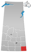
Gainsborough (2016 population: 254) is a village in the Canadian province of Saskatchewan within the Rural Municipality of Argyle No. 1 and Census Division No. 1. A farming community, the village is located on Highway 18 in the southeastern corner of Saskatchewan. Gainsborough is approximately 6 kilometres (3.7 mi) from the Manitoba border, and 19 kilometres (12 mi) from the North Dakota, United States border. The first post office was established on April 1, 1884[1] as the community of Antler. On September 1, 1885, the name of the community changed to Gainsborough,[2] after Gainsborough, Lincolnshire in England, which was the former home of J. J. Sadler, an early settler.[3] Location8 miles east is the community of Pierson, Manitoba. To the west 8 miles is the village of Carievale. 16 miles straight north of Gainsborough is the hamlet of Fertile. The closest communities to the south are Antler and Sherwood, North Dakota. Nearby towns to the north and west are Storthoaks, Carnduff, Glen Ewen, Oxbow, and Bellegarde, while to the east are Lyleton, Tilston and Melita, Manitoba. The nearest population centres with more than 10,000 people are approximately an hour's drive away: Estevan, which is westward on Highway 18, and Minot, North Dakota is a 75-minute drive almost directly south. Brandon is a 2-hour drive away, while Regina, Saskatchewan and Winnipeg are each approximately 3.0-3.5 hours away by car. Antler is the closest border crossing station between Canada and the US, and like most small posts on the frontier it is closed overnight. Gainsborough is approximately equidistant to two 24-hour border crossings: North Portal, Saskatchewan 90 km to the west, and Boissevain, Manitoba 120 km to the east. HistoryGainsborough incorporated as a village on May 25, 1894.[4] The Gainsborough Creek forms most of the southern boundary of the town, while the rest of the community is bordered by open fields and pasture. A tributary of the Souris River, the creek is prone to flooding during the spring thaw. Though several nearby communities made national headlines as disaster areas during severe flooding in 2011, most buildings in Gainsborough did not require unusual extraordinary protection measures or sandbagging. In 2014, extended heavy rainfall in the region resulted in severe flash flooding that forced the complete evacuation of residents to neighbouring communities and made national headlines.[5][6][7][8] Provincial premier Brad Wall did an aerial survey of the flood area that allowed images and video of the flooded village to be recorded near the maximum height of the waters.[9][10] DemographicsIn the 2021 Census of Population conducted by Statistics Canada, Gainsborough had a population of 227 living in 113 of its 144 total private dwellings, a change of -10.6% from its 2016 population of 254. With a land area of 0.94 km2 (0.36 sq mi), it had a population density of 241.5/km2 (625.5/sq mi) in 2021.[13] In the 2016 Census of Population, the Village of Gainsborough recorded a population of 254 living in 124 of its 144 total private dwellings, a -14.6% change from its 2011 population of 291. With a land area of 0.87 km2 (0.34 sq mi), it had a population density of 292.0/km2 (756.2/sq mi) in 2016.[14] EconomySaskatchewan is in the CST Zone, and since 1967 it has not observed daylight saving time meaning that local clocks do not get changed in summer. A practical effect on border towns like Gainsborough is that they only align with neighbouring communities in Manitoba and North Dakota for half the year, which may lead to misunderstandings regarding the timing of scheduled inter-community events. Primary income of community members is derived from agricultural businesses (farming, ranching) and petroleum drilling services. Places of interest
Amenities, associations, and clubs
Notable people
Gallery
See also
References
External links
|
||||||||||||||||||||||||||||||||||||||||||||||||||||||||||||


