Share to: share facebook share twitter share wa share telegram print page

Mountrail County, North Dakota

Mountrail County
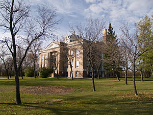
Mountrail County Courthouse in Stanley
Map of North Dakota highlighting Mountrail County
Location within the U.S. state of North Dakota
Map of the United States highlighting North Dakota
North Dakota's location within the U.S.
Coordinates: 48°12′N 102°22′W / 48.2°N 102.37°W / 48.2; -102.37
Country United States
State North Dakota
FoundedJanuary 4, 1873
1892 (eliminated)
January 29, 1909 (reestablished)
SeatStanley
Largest cityNew Town
Area
 • Total
1,942 sq mi (5,030 km2)
 • Land1,825 sq mi (4,730 km2)
 • Water116 sq mi (300 km2)  6.0%
Population
 (2020)
 • Total
9,809
 • Estimate 
(2023)
9,383 Decrease
 • Density5.1/sq mi (2.0/km2)
Time zoneUTC−6 (Central)
 • Summer (DST)UTC−5 (CDT)
Congressional districtAt-large
Websitewww.co.mountrail.nd.us

Mountrail County is a county in the northwestern part of North Dakota, United States. As of the 2020 census, the population was 9,809.[1] Its county seat is Stanley.[2] The county was originally created in 1873, then removed in 1892, annexed by Ward County. It was re-created and organized in 1909.[3][4] The county is home to the headquarters of the Three Affiliated Tribes of the Mandan, Hidatsa, and Arikara people, and a large part of the county belongs to the tribe's Fort Berthold reservation.[5][6]

History

The Dakota Territory legislature created the county (as Mountraille County) on January 4, 1873, with area annexed from Buffalo County. The origin of its name came from Joseph Mountraille, a locally famed Metis voyageur and mail carrier from Pembina under Norman Kittson's employment.[7][8] The county was not organized at that time, nor was it attached to another county for administrative or judicial purposes. The new county lost territory in 1885 when a portion was annexed off to create Garfield County (now extinct). This situation continued until February 21, 1891, when Mountrail County was attached to Ward County, for "judicial and other purposes". The following year (November 8, 1892), the North Dakota legislature voted to dissolve the county and have its territory absorbed by Ward County.

An election held in Ward County on November 3, 1908, authorized the re-creation of Mountrail County, although with different boundaries than the previous county proposal. The countywide vote totals were 4207 to 4024, but the result was contested in court. On January 16, 1909, the state Supreme Court upheld the vote,[9] so the county government was organized on January 29 of that year.[4][10][11]

Oil production from the Bakken formation in the early 21st century attracted workers and reversed decades of population decline in the county. From 2010 to 2015, especially, population markedly increased, creating its own strains.

Outline map of Mountrail County, North Dakota, 1917

Geography

The Missouri River flows southeastward along the SW boundary line of Mountrail County, and Shell Creek drains the lower central part of the county into the Missouri, discharging at Shell Creek Bay. The terrain consists of rolling hills, largely devoted to agriculture. Its NE portion is dotted with ponds and lakes.[12] The Laurentian Divide runs east–west through the central part of the county, with the northern areas sloping to the north and the southern areas sloping to the south. Its highest point is on the upper west boundary line, at 2,480 ft (760 m) ASL.[13] The county has a total area of 1,942 square miles (5,030 km2), of which 1,825 square miles (4,730 km2) is land and 116 square miles (300 km2) (6.0%) is water.[14]

Mountrail County is one of several western North Dakota counties with significant exposure to the Bakken Formation in the Williston Basin.

Major highways

Transit

Adjacent counties

Protected areas[12]

Lakes[12]

  • Cottonwood Lake
  • Lake Sakakawea
  • Powers Lake (part)
  • Rat Lake
  • Robinson Lake
  • Shell Lake
  • Van Hook Arm
  • White Lake

Demographics

Historical population
CensusPop.Note
19108,491
192012,14043.0%
193013,54411.6%
194010,482−22.6%
19509,418−10.2%
196010,0777.0%
19708,437−16.3%
19807,679−9.0%
19907,021−8.6%
20006,631−5.6%
20107,67315.7%
20209,80927.8%
2023 (est.)9,383[15]−4.3%
U.S. Decennial Census[16]
1790-1960[17] 1900-1990[18]
1990-2000[19] 2010-2020[1]

2020 census

As of the 2020 census, there were 9,809 people, 3,715 households, and 2,407 families in the county.[20] The population density was 5.4 inhabitants per square mile (2.1/km2) There were 5,108 housing units.

2010 census

As of the 2010 census, there were 7,673 people, 2,793 households, and 1,852 families in the county. The population density was 4.20 people per square mile (1.62 people/km2). There were 4,119 housing units at an average density of 2.26 units per square mile (0.87/km2). The racial makeup of the county was 65.6% White, 30.6% Native American, 0.2% Black or African American, 0.2% Asian, 0.8% from other races, and 2.6% from two or more races. Those of Hispanic or Latino origin made up 3.7% of the population. In terms of ancestry, 36.6% were Norwegian, 24.4% were German, 6.6% were Irish, and 0.8% were American.

Of the 2,793 households, 31.1% had children under the age of 18 living with them, 48.3% were married couples living together, 11.4% had a female householder with no husband present, 33.7% were non-families, and 28.3% of all households were made up of individuals. The average household size was 2.55 and the average family size was 3.11. The median age was 37.0 years.

The median income for a household in the county was $53,912 and the median income for a family was $63,238. Males had a median income of $43,386 versus $29,432 for females. The per capita income for the county was $25,762. About 13.5% of families and 16.5% of the population were below the poverty line, including 24.2% of those under age 18 and 14.2% of those age 65 or over.

Population by decade

Communities

Cities

Unincorporated communities[12]

Government

Aspects of county government are subdivided into townships.

Townships

Politics

Mountrail County was historically a swing county, but now leans strongly Republican. Bill Clinton won both of his terms, and Barack Obama carried this county in the 2008 election. However, he wasn't able to carry this county in 2012, falling to Republican Mitt Romney by over 16%. Kamala Harris received the smallest vote by a Democratic candidate (27.6%) since Progressive Party candidate Robert La Follette received an overwhelming vote in 1924.

United States presidential election results for Mountrail County, North Dakota[21][22]
Year Republican Democratic Third party(ies)
No.  % No.  % No.  %
2024 2,877 70.64% 1,125 27.62% 71 1.74%
2020 2,824 67.80% 1,256 30.16% 85 2.04%
2016 2,582 62.88% 1,220 29.71% 304 7.40%
2012 1,962 56.75% 1,403 40.58% 92 2.66%
2008 1,406 47.86% 1,477 50.27% 55 1.87%
2004 1,527 50.40% 1,465 48.35% 38 1.25%
2000 1,466 50.62% 1,256 43.37% 174 6.01%
1996 965 36.90% 1,277 48.83% 373 14.26%
1992 1,017 30.92% 1,393 42.35% 879 26.73%
1988 1,443 41.73% 1,977 57.17% 38 1.10%
1984 1,959 55.11% 1,565 44.02% 31 0.87%
1980 2,165 60.36% 1,183 32.98% 239 6.66%
1976 1,430 38.57% 2,189 59.03% 89 2.40%
1972 2,038 58.30% 1,391 39.79% 67 1.92%
1968 1,494 44.33% 1,662 49.32% 214 6.35%
1964 1,131 30.71% 2,548 69.18% 4 0.11%
1960 1,894 45.50% 2,264 54.38% 5 0.12%
1956 1,699 47.23% 1,891 52.57% 7 0.19%
1952 2,516 62.93% 1,437 35.94% 45 1.13%
1948 1,395 42.22% 1,521 46.04% 388 11.74%
1944 1,666 45.11% 1,981 53.64% 46 1.25%
1940 1,981 44.67% 2,392 53.93% 62 1.40%
1936 700 14.68% 2,775 58.19% 1,294 27.13%
1932 986 22.17% 3,284 73.83% 178 4.00%
1928 2,354 52.30% 2,003 44.50% 144 3.20%
1924 1,354 36.19% 130 3.48% 2,257 60.33%
1920 2,960 72.73% 687 16.88% 423 10.39%
1916 740 32.64% 1,262 55.67% 265 11.69%
1912 407 28.05% 307 21.16% 737 50.79%

Education

School districts include:[23]

See also

References

  1. ^ a b "State & County QuickFacts". United States Census Bureau. Retrieved May 9, 2024.
  2. ^ "Find a County". National Association of Counties. Retrieved June 7, 2011.
  3. ^ "County History". North Dakota.gov. The State of North Dakota. Archived from the original on February 2, 2015. Retrieved February 1, 2015.
  4. ^ a b Long, John H. (2006). "Dakota Territory, South Dakota, and North Dakota: Individual County Chronologies". Dakota Territory Atlas of Historical County Boundaries. The Newberry Library. Archived from the original on November 11, 2007. Retrieved February 25, 2019.
  5. ^ "Our Tribe". MHA Nation. Retrieved June 28, 2024.
  6. ^ "Mountrail County ND". www.nd-direct.com. Retrieved June 28, 2024.
  7. ^ "County History - North Dakota State Government - ND Portal". nd.gov. State of North Dakota. Retrieved May 11, 2023.
  8. ^ Lounsberry, Clement A. (Clement Augustus) (1919). Early history of North Dakota: essential outlines of American history. Washington, D. C.: Liberty Press. p. 237. Retrieved May 11, 2023.
  9. ^ State ex rel. McCue v. Blaisdell, 119 N.W. 360 (N.D. 1909).
  10. ^ "Dakota Territory Historical Counties: Interactive Map". Atlas of Historical County Boundaries. The Newberry Library. Archived from the original on August 11, 2006. Retrieved July 6, 2010.
  11. ^ "North Dakota Historical Counties: Interactive Map". Atlas of Historical County Boundaries. The Newberry Library. Archived from the original on August 11, 2006. Retrieved July 6, 2010.
  12. ^ a b c d "Mountrail County · North Dakota". Google Maps. Retrieved April 27, 2024.
  13. ^ ""Find an Altitude/Mountrail County ND" Google Maps (accessed February 25, 2019)". Archived from the original on May 21, 2019. Retrieved February 25, 2019.
  14. ^ "2010 Census Gazetteer Files". United States Census Bureau. August 22, 2012. Archived from the original on January 29, 2015. Retrieved February 1, 2015.
  15. ^ "Annual Estimates of the Resident Population for Counties: April 1, 2020 to July 1, 2022". Retrieved April 1, 2023.
  16. ^ "U.S. Decennial Census". United States Census Bureau. Retrieved February 1, 2015.
  17. ^ "Historical Census Browser". University of Virginia Library. Retrieved February 1, 2015.
  18. ^ Forstall, Richard L., ed. (April 20, 1995). "Population of Counties by Decennial Census: 1900 to 1990". United States Census Bureau. Retrieved February 1, 2015.
  19. ^ "Census 2000 PHC-T-4. Ranking Tables for Counties: 1990 and 2000" (PDF). United States Census Bureau. April 2, 2001. Archived (PDF) from the original on March 27, 2010. Retrieved February 1, 2015.
  20. ^ "US Census Bureau, Table P16: Household Type". United States Census Bureau. Retrieved May 9, 2024.
  21. ^ Leip, David. "Atlas of US Presidential Elections". uselectionatlas.org. Retrieved December 23, 2020.
  22. ^ The leading "other" candidate, Socialist Eugene Debs received 372 votes, Progressive Theodore Roosevelt, received 347 votes, while Prohibition candidate Eugene Chafin received 18 votes.
  23. ^ "2020 CENSUS - SCHOOL DISTRICT REFERENCE MAP: Mountrail County, ND" (PDF). U.S. Census Bureau. Retrieved November 30, 2024. - Text list
  • Mountrail County maps, Sheet 1 (northern) and Sheet 2 (southern), North Dakota DOT

48°12′N 102°22′W / 48.20°N 102.37°W / 48.20; -102.37

Read other articles:

1990 Non-circulating coins Face value Coin Obverse design Reverse design Composition Mintage Available Obverse Reverse $1 Eisenhower Centennial dollar[1] 2 profiles of Eisenhower Eisenhower's house near Gettysburg, PA, now part of Eisenhower Nat'l Historic Site Ag 90%, Cu 10% Authorized: 4,000,000 (max) Uncirculated: 241,669 W Proof: 1,144,461 P 1990 1991 Non-circulating coins Face value Coin Obverse design Reverse design Composition Mintage Available Obverse Reverse 50¢ Mount Rushmore …

UMY beralih ke halaman ini. Untuk kegunaan lain, lihat UMY (disambiguasi). Muhammadiyah University of YogyakartaUniversitas Muhammadiyah YogyakartaNama lainꦈꦤꦶꦮ꦳ꦼꦂꦱꦶꦠꦱ꧀​ꦩꦸꦲꦩ꧀ꦩꦢꦶꦪꦃ​ꦔꦪꦺꦴꦒꦾꦏꦂꦠMotoUnggul dan Islami Muda MenduniaJenisPerguruan Tinggi SwastaDidirikan1 Maret 1981AfiliasiIslamRektorProf. Dr. Ir. Gunawan Budiyanto, M.P., IPM.AlamatJl. Brawijaya, Tamantirto, Kec. Kasihan, Kabupaten Bantul, Daerah Istimewa Yogyakarta, Indone…

Nick AldisAldis pada Januari 2013Nama lahirNicholas AldisLahir6 November 1986 (umur 37)Docking, Norfolk, InggrisPasanganMickie James ​(m. 2015)​Anak1Karier gulat profesionalNama ringBrutus Magnus[1][2]Magnus[3]Nick Aldis[1]Sir Brutus Magnus[4]Tinggi6 ft 4 in (193 cm)[5]Berat242 pon (110 kg)[5]Asal dariKing's Lynn, Inggris[1][2]Dilatih olehDropkixx Academy[6]F…

Creation of clothing from an aesthetic standpoint See also: Stage clothes Costume design for Gianetta - The Gondoliers Part of a series onCostume Background History Industry Costume coordination Use of costume in Athenian tragedy Wardrobe supervisor Society and culture Fursuit Cosplay Costume party Masque Masquerade ball Parade World Costume Festival Design Costume design Costume designer Spirit gum Elements and methods Body painting Disguise Fake moustache Fatsuit Illusion costume Inflatable co…

2013 video game 2013 video gameRisk of RainDeveloper(s)Hopoo GamesPublisher(s)Gearbox Publishing[a]Producer(s)Duncan DrummondPaul MorseDesigner(s)Matthew GriffinDuncan DrummondPaul MorseProgrammer(s)Duncan DrummondArtist(s)Duncan DrummondComposer(s)Chris ChristodoulouEngineGameMakerPlatform(s)Windows, OS X, Linux, PlayStation 4, PlayStation Vita, Nintendo Switch, Xbox OneRelease November 8, 2013 WindowsNovember 8, 2013OS X, LinuxOctober 28, 2014PS4, VitaApril 12, 2016SwitchSeptember 20, …

SodalitUmumKategoriTektosilikat tanpa H2O zeolitikRumus(unit berulang)Na8(Al6Si6O24)Cl2Klasifikasi Strunz9.FB.10Sistem kristalKubikKelas kristalHekstetrahedral (43m) H-M symbol: (4 3m)Grup ruangP43nSel unita = 8.876(6) Å; Z = 1IdentifikasiWarnaRoyal blue, hijau, kuning, violet, umumnya berurat putihPerawakanMasif; kadang-kadang (jarang) berbentuk dodekahedraBentuk kembaranUmum pada {111} membentuk prisma pseudoheksagonalBelahanBuruk pada {110}FrakturKonkoida hingga tidak rataSifa…

العلاقات المالطية الهندوراسية مالطا هندوراس   مالطا   هندوراس تعديل مصدري - تعديل   العلاقات المالطية الهندوراسية هي العلاقات الثنائية التي تجمع بين مالطا وهندوراس.[1][2][3][4][5] مقارنة بين البلدين هذه مقارنة عامة ومرجعية للدولتين: وجه المقارنة…

Arena in Chicago, United States Credit Union 1 ArenaFormer namesUIC Pavilion (1982–2018)Location525 South Racine AvenueChicago, Illinois 60607Coordinates41°52′29″N 87°39′22″W / 41.87472°N 87.65611°W / 41.87472; -87.65611OwnerUniversity of Illinois ChicagoOperatorUniversity of Illinois ChicagoCapacity10,300 (concerts), 9,500 (boxing and wrestling), 8,000 (basketball)SurfaceConcreteConstructionBroke groundJune 1, 1979[1]OpenedMay 31, 1982Renovated2001C…

La Domnonée (lat. Dumnonia) désigne au VIe siècle un royaume brittonique centré sur le Sud-Ouest de l'Angleterre. Le terme est ensuite employé à partir du VIIIe siècle dans l'hagiographie bretonne pour désigner une partie de la péninsule armoricaine[1]. Situations géographiques Grande-Bretagne En Grande-Bretagne, alors appelée « Bretagne insulaire », ce royaume s'est étendu sur l'actuel comté de Devon (ce dernier nom étant l'évolution du mot Dumnonia), et ant…

This article needs additional citations for verification. Please help improve this article by adding citations to reliable sources. Unsourced material may be challenged and removed.Find sources: The Fiddle's Requiem – news · newspapers · books · scholar · JSTOR (October 2016) (Learn how and when to remove this message) 1911 American filmThe Fiddle's RequiemJP McGowan (left), Robert Vignola (right)Directed bySidney OlcottProduced bySidney OlcottStarringGen…

Diplomatic visit by US House Speaker Nancy Pelosi and five other Democratic House members 2022 visit by Nancy Pelosi to TaiwanNancy Pelosi and President Tsai Ing-wen hold a press conference in Taiwan's Presidential Office.DateAugust 2–3, 2022 (2022-08-02 – 2022-08-03)LocationTaipei, Taiwan United States politician Nancy Pelosi, while serving as the speaker of the U.S. House of Representatives, visited Taiwan (officially the Republic of China) on August 2, 2022. A delegati…

Pour les articles homonymes, voir Bastié. Jean BastiéJean Bastié en 2001.FonctionsPrésidentSociété de géographie1995-2009Jacqueline Beaujeu-GarnierJean-Robert PitteSecrétaire généralAnnales de géographieBiographieNaissance 6 mars 1919ToulouseDécès 9 avril 2018 (à 99 ans)14e arrondissement de ParisNationalité françaiseActivité GéographeAutres informationsA travaillé pour Institut de géographieUniversité Paris-SorbonneDistinction Médaille d'argent du CNRS (1968)modifier …

Tamil vegetable side dish This article needs additional citations for verification. Please help improve this article by adding citations to reliable sources. Unsourced material may be challenged and removed.Find sources: Kuzhambu – news · newspapers · books · scholar · JSTOR (September 2023) (Learn how and when to remove this message) KuzhambuEnnai kathirikkai kuzhambu (Stuffed eggplant kuzhambu)Place of originTamil Nadu, IndiaRegion or stateSouth India a…

Cocktail CasinoIBA official cocktailCasinoTypeCocktailBase spirit Gin ServedStraight up: chilled, without iceStandard garnishLemon twist and maraschino cherryStandard drinkware Cocktail glassIBA specifiedingredients† 4 cl gin (Old Tom) 1 cl Maraschino 1 cl fresh lemon juice 2 dashes orange bitters PreparationPour all ingredients into shaker with ice cubes. Shake well. Strain into chilled cocktail glass. Garnish with a lemon twist and a maraschino cherry. Serve without a straw.Commonly servedAl…

American basketball player (born 1993) Tony WrotenWroten in a 2019-20 ACB match with Club Joventut BadalonaPersonal informationBorn (1993-04-13) April 13, 1993 (age 31)Seattle, Washington, USListed height6 ft 6 in (1.98 m)Listed weight205 lb (93 kg)Career informationHigh schoolGarfield (Seattle, Washington)CollegeWashington (2011–2012)NBA draft2012: 1st round, 25th overall pickSelected by the Memphis GrizzliesPlaying career2012–2022PositionPoint guard / shooting…

本條目存在以下問題,請協助改善本條目或在討論頁針對議題發表看法。 此條目需要补充更多来源。 (2017年12月19日)请协助補充多方面可靠来源以改善这篇条目,无法查证的内容可能會因為异议提出而被移除。致使用者:请搜索一下条目的标题(来源搜索:若望保祿二世 — 网页、新闻、书籍、学术、图像),以检查网络上是否存在该主题的更多可靠来源(判定指引)。 此…

此條目可参照英語維基百科相應條目来扩充。 (2021年5月6日)若您熟悉来源语言和主题,请协助参考外语维基百科扩充条目。请勿直接提交机械翻译,也不要翻译不可靠、低品质内容。依版权协议,译文需在编辑摘要注明来源,或于讨论页顶部标记{{Translated page}}标签。 约翰斯顿环礁Kalama Atoll 美國本土外小島嶼 Johnston Atoll 旗幟颂歌:《星條旗》The Star-Spangled Banner約翰斯頓環礁地…

Railway maintenance depot in Blackpool, Lancashire Blackpool Train Maintenance DepotDepot sidings after electrification (2018)LocationLocationBlackpool, Lancashire, EnglandCoordinates53°49′39″N 3°02′37″W / 53.8276°N 3.0435°W / 53.8276; -3.0435OS gridSD313373CharacteristicsOwnerNetwork RailOperatorNorthern TrainsDepot codeBPTypeDMU, EMU Blackpool Train Maintenance Depot is a traction maintenance depot located in Blackpool, Lancashire, England. Blackpool TMD's T…

Jean-FrédéricTitre de noblesseMargraveBiographieNaissance 18 octobre 1654AnsbachDécès 22 mars 1686 ou 1er avril 1686AnsbachSépulture Église Saint-Gumbertus d'AnsbachNom dans la langue maternelle Johann Friedrich von Brandenburg-AnsbachFormation Université de Strasbourg (d)Université de GenèveActivités Collectionneur d'œuvres d'art, homme politiqueFamille Maison de HohenzollernPère Albert IIMère Sophie-Marguerite d'Oettingen-OettingenFratrie Dorothée-Charlotte de Brandebourg-An…

1980 book by Robert Boettcher Gifts of Deceit Book coverAuthorRobert BoettcherCountryUnited StatesLanguageEnglishSubjectPolitics, South Korea United States relations, Unification movementGenrenon-fictionPublisherHolt, Rinehart and WinstonPublication date1980Media typeHardcoverPages402ISBN978-0-03-044576-7 Gifts of Deceit: Sun Myung Moon, Tongsun Park, and the Korean Scandal is a 1980 non-fiction book on Koreagate and the Fraser Committee, a congressional subcommittee which investigated Sout…

Kembali kehalaman sebelumnya