Share to: share facebook share twitter share wa share telegram print page


Okhotnykove

Okhotnykove
Cağa Quşçu Camisi mosque in Okhotnikovo
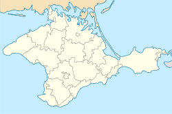
Okhotnykove is located in Crimea
Okhotnykove
Okhotnykove
Okhotnykove is located in Ukraine
Okhotnykove
Okhotnykove
Coordinates: 45°14′21″N 33°35′39″E / 45.23917°N 33.59417°E / 45.23917; 33.59417
Country Ukraine
(occupied by Russia)
Republic Crimea
Raion Saky Raion
First mentioned1806
Population
 (2014)
 • Total
1,550

Okhotnykove (Ukrainian: Охотникове; Russian: Охотниково, romanizedOkhotnikovo), known officially until 1948 by its Crimean Tatar name of Cağa Quşçu (Ukrainian: Джага-Кущи, romanizedDzhaha-Kushchy; Russian: Джага́-Кущу́, romanizedDzhaga-Kushchu) is a village in Crimea, a peninsula internationally recognised as part of Ukraine but occupied by Russia since 2014. It is currently administered as part of Saky Raion.

History

Okhotnykove was first mentioned in a document dating to 19 April 1806, where its population was listed, in seventeen households, as including 105 Crimean Tatars, ten Crimean Roma, and four slaves.[1] Between 1860 and 1864, the village was completely depopulated after its inhabitants fled amidst the Crimean War, and repopulated by Volga Tatars.[2]

In 1926, the village had a population of 95. Of this population, 59 were Ukrainians, 24 were Tatars, and 13 were Estonians.[3] With the deportation of the Crimean Tatars, the village was renamed to Okhotnykove by an act of the Presidium of the Supreme Soviet on 18 May 1948.[4]

In 2011, the Okhotnykovo Solar Park was constructed in the village by Activ Solar.[5]

Demographics

According to the 2001 Ukrainian census, 69.7 percent of people in Okhotnykove spoke Russian, with 16.8 percent speaking Ukrainian and another 12.2 percent speaking Crimean Tatar.[6] The total population of Okhotnykove was 1,550 according to the 2014 Crimean census,[7] a decline from its 2001 population of 1,696.[8]

References

  1. ^ Lashkov, Fyodor (1897). Сборник документов по истории Крымско-татарского змлевладения (Окончание) [Collection of Documents on the History of Crimean Tatar Land Ownership] (in Russian). Simferopol: Tavrich. Gub. Tip. p. 151.
  2. ^ Khanatskago, K. V. (1867). Памятная книжка Таврической губерніи [Memorial Book of Taurida Governorate] (in Russian). Simferopol: Printing House of Taurida Governorate. p. 427.
  3. ^ Список населенных пунктов Крымской АССР [List of settlements in the Crimean ASSR] on Wikimedia Commons. Accessed 8 August 2023
  4. ^ Указ Президиума ВС РСФСР от 18.05.1948 о переименовании населённых пунктов Крымской области [Act by the Presidium of the SS RSFSR from 18.5.1948 on renaming settlements in the Crimean Oblast] on Wikisource. Accessed 8 August 2023
  5. ^ "Mission accomplished for Activ Solar: final phase of Ukraine solar plant completed". pv-tech.org. 30 September 2011.
  6. ^ "Розподіл населення за рідною мовою, Автономна Республіка Крим" [Population distribution by native language, Autonomous Republic of Crimea]. All-Ukrainian Population Census (in Ukrainian). Archived from the original on 6 March 2016. Retrieved 8 August 2023.
  7. ^ "Таблицы с итогами Федерального статистического наблюдения "Перепись населения в Крымском федеральном округе"" [Tables with the results of the Federal Statistical Observation "Population Census in the Crimean Federal District"]. Federal State Statistics Service of Russia (in Russian). Archived from the original on 24 September 2015. Retrieved 8 August 2023.
  8. ^ "Автономна Республіка Крим" [Autonomous Republic of Crimea]. Pop-stat.mashke.org (in Ukrainian). Archived from the original on 4 October 2013. Retrieved 8 August 2023.
Prefix: a b c d e f g h i j k l m n o p q r s t u v w x y z 0 1 2 3 4 5 6 7 8 9

Portal di Ensiklopedia Dunia

Kembali kehalaman sebelumnya