Share to: share facebook share twitter share wa share telegram print page

1933 Long Beach earthquake

1933 Long Beach earthquake
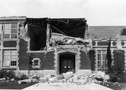
Damage to the John Muir School, Pacific Avenue, Long Beach
1933 Long Beach earthquake is located in California
1933 Long Beach earthquake
Los Angeles
Los Angeles
UTC time1933-03-11 01:54:00
ISC event905457
USGS-ANSSComCat
Local dateMarch 10, 1933 (1933-03-10)
Local time5:54 P.M. PST[1]
Magnitude6.4 Mw [2]
Depth10 km (6.2 mi) [2]
Epicenter33°37′52″N 118°00′00″W / 33.631°N 118.000°W / 33.631; -118.000 [3]
FaultNewport-Inglewood Fault[4]
TypeStrike-slip[5]
Areas affectedSouth Coast (California)
United States
Total damage$40 million [1]
Max. intensityMMI VIII (Severe) [1]
Peak acceleration0.22 g [6]
Peak velocity20 cm/s (est) [7]
TsunamiNo
AftershocksM5.4 on Oct 2 1933 [8]
Casualties115–120 killed [1][9]
Camping out in Southgate, California after an earthquake on March 10, 1933

The 1933 Long Beach earthquake took place on March 10 at 5:54 P.M. PST south of downtown Los Angeles. The epicenter was offshore, southeast of Long Beach, California, on the Newport–Inglewood Fault.[10] The earthquake had a magnitude estimated at 6.4 Mw, and a maximum Mercalli intensity of VIII (Severe). Damage to buildings was widespread throughout Southern California. It resulted in 115 to 120 fatalities and an estimated $40 million worth of property damage, equivalent to $941 million in 2023. The majority of the fatalities resulted from people running out of buildings exposing themselves to the falling debris.

Damage

Damaged buildings throughout Long Beach
Compton Union High School
Compton Junior High School
Damage to building in Long Beach.
Destroyed building in Huntington Park

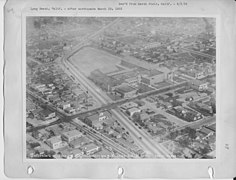
Major damage occurred in the densely populated city of Long Beach on the south-facing coast of Los Angeles County. However, the damage was also found in the industrial area south of downtown Los Angeles. An estimated 75,000 mi2 area was impacted, being felt as far as San Joaquin Valley, Owens Valley, and Northern Baja California. The magnitude of the earthquake is considered medium, but a significant amount of damage occurred due to unfavorable geological conditions (landfill, water-soaked alluvium) combined with poorly constructed buildings. At Long Beach, buildings collapsed, water tanks fell through roofs, and houses were tossed off their foundations. School buildings were among the structures that incurred the most severe damage.[11] Within seconds, 120 schools within the Long Beach area were damaged, 70 of which were destroyed. It was recognized that unreinforced masonry bearing walls were the reason that school buildings suffered so much damage.[12] On March 20, 2008, a Los Angeles Times article stated that "the 1933 quake changed the landscape, leading to improved school construction standards and a heightened awareness of earthquake risks."[13] Among other buildings, the La Grande Station, the main Los Angeles terminal of the Atchison, Topeka, and Santa Fe Railroad, was heavily damaged.[14]

Aftermath

The earthquake highlighted the need for earthquake-resistant design for structures in California. More than 230 school buildings either were destroyed, suffered major damage, or were judged unsafe to occupy. Casualties would have been much higher had the earthquake occurred a few hours earlier while school was in session. Many schools were permanently closed for a long time due to the building being unsafe for inhabitation or not meeting earthquake safety regulations at the time. Since these schools were deemed unsafe, students would report to classes held in tents. Large sums of money were needed to upgrade these damaged school buildings.[15]

Only 30 days after the earthquake, Governor James Rolph Jr. signed the Field Act to govern the planning, design and construction of public school buildings.[16] The Field Act mandated that building designs be based on high-level building standards adopted by the state and enforced by independent plan review and inspection. The plans and specifications must be prepared by competent designers qualified through state registration.[17]

A group of local scientists, architects, and builders formed a Joint Technical Committee on Earthquake Protection to propose ways to minimize loss of life and property in future earthquakes. The committee was chaired by CalTech physicist Robert Millikan, and included architects John C. Austin and Sumner Hunt. In June 1933 they released their report, which advocated for stronger building codes.

The Bureau of Public Roads also took action to rebuild roads, highways, and bridges.[18] The economy of Long Beach was able to return to normal swiftly because of the rise of the aircraft industry. To support the World War II efforts, Long Beach created naval yards and increased the number of aircraft produced. This directly helped Long Beach repair and stabilize the economy after the disaster.[19]

This earthquake prompted the federal government to play an active role in disaster relief. The government created the Reconstruction Finance Corporation, providing loans for reconstructing buildings that were affected during the natural disaster.

The damage to the La Grande Station indirectly led to the construction of Los Angeles Union Station, which was built on top of what was at that time the Chinatown, Los Angeles.[20]

Cause

The epicenter and its relative location to offshore faults

A 2016 press release by the United States Geological Survey indicates that research shows the 1933 Long Beach earthquake may have been man-made, caused by oil and gas extraction underneath the city.[21] Further studies indicate that several, if not most earthquakes during the peak years of Los Angeles's oil boom were likely caused by tectonic stress induced by methods used at the time which did not replace the millions of barrels of removed oil with other liquids.[22][23] A study done by the USGS suggests that drilling in a Huntington Beach area caused the 1933 earthquake. Other studies done by the USGS have also indicated that oil drilling may have been responsible for earthquakes in the surrounding areas in the 1920s. This study was done by two scientists that studied early state oil drilling records. They found that the epicenters of these earthquakes were located near areas where significant changes[clarification needed] occurred in oil production areas.[24] Man-made earthquakes are still an issue, especially in Oklahoma and Texas. Recent studies have shown that the injection of wastewater into the ground increases the occurrence of earthquakes.[25]

Within the Los Angeles depositional basin, northwest-trending groups of faulted anticlines were viewed to be caused by oil and gas extraction underneath the city. The extraction of oil and gas produces salty water,[clarification needed] adding stress to faults, causing earthquakes. Often wastewater and natural gas production will increase the magnitude of the earthquake making them even more dangerous.[further explanation needed][26]

The Newport–Inglewood Fault, the source of the 1933 earthquake, is a right-lateral strike-slip fault trending northwest–southeast, and parallel to other major right-lateral faults in California. The fault spans about 46 miles onshore from Culver City to Newport Beach, where it enters the Pacific Ocean. This fault is expected to produce an earthquake of magnitude 7.4.[27] The 1933 Long Beach earthquake was only a magnitude of about 6.4, approximately ten times less vibration amplitude and 1,000 times less energy release than that of a magnitude of 7.4 earthquake.[citation needed]

Appearances in documentaries and popular culture

The earthquake plays a significant part in the novel The Last Tycoon (1941) by F. Scott Fitzgerald. During the disruption caused by the quake, the hero, Monroe Stahr, meets Kathleen Moore, with whom he falls in love.

The earthquake is also included in John Fante's Ask the Dust (1939), and the earthquake scene in the novel is subject of a public art installation in Pershing Square called "Hey Day" by Barbara McCarren.

Footage of the earthquake appeared in the film Encounter with Disaster, released in 1979 and produced by Sun Classic Pictures.

Gallery

See also

References

  1. ^ a b c d Stover, C. W.; Coffman, J. L. (1993), Seismicity of the United States, 1568–1989 (Revised) – U.S. Geological Survey Professional Paper 1527, United States Government Printing Office, pp. 78, 130, 131, archived from the original on 2019-04-13, retrieved 2016-10-29
  2. ^ a b ISC (2015), ISC-GEM Global Instrumental Earthquake Catalogue (1900–2009), Version 2.0, International Seismological Centre, archived from the original on 2019-05-20, retrieved 2015-07-12
  3. ^ USGS. "M6.4 – 7km WNW of Newport Beach, CA". United States Geological Survey. Archived from the original on 2018-03-16. Retrieved 2017-08-28.
  4. ^ "Southern California Earthquake Data Center: Long Beach Earthquake". scedc.caltech.edu. Retrieved 2021-10-26.
  5. ^ Hauksson, E.; Gross, S. (1991), "Source parameters of the 1933 Long Beach earthquake" (PDF), Bulletin of the Seismological Society of America, 81 (1), Seismological Society of America: 81, archived (PDF) from the original on 2016-04-23, retrieved 2016-04-09
  6. ^ "The 1933 Long Beach Earthquake".
  7. ^ Hough, S. E.; Graves, R. W. (22 June 2020). "Nature:The 1933 Long Beach Earthquake (California, USA) Ground Motions and Rupture Scenario". Scientific Reports. 10 (1): 10017. Bibcode:2020NatSR..1010017H. doi:10.1038/s41598-020-66299-w. PMC 7308333. PMID 32572047.
  8. ^ Hough, S. E.; Graves, R. W. (22 June 2020). "Nature:The 1933 Long Beach Earthquake (California, USA) Ground Motions and Rupture Scenario". Scientific Reports. 10 (1): 10017. Bibcode:2020NatSR..1010017H. doi:10.1038/s41598-020-66299-w. PMC 7308333. PMID 32572047.
  9. ^ National Geophysical Data Center / World Data Service (NGDC/WDS) (1972), Significant Earthquake Database (Data Set), National Geophysical Data Center, NOAA, doi:10.7289/V5TD9V7K, archived from the original on 2017-07-21, retrieved 2016-04-09
  10. ^ "Southern California Earthquake Data Center: Long Beach Earthquake". scedc.caltech.edu. Retrieved 2021-05-01.
  11. ^ Public Domain This article incorporates public domain material from Earthquake History of California. United States Geological Survey. Archived from the original on 2000-08-17. Retrieved 2018-05-02.
  12. ^ Green, Melvyn; Watson, Anne L. (1988). "Building Codes: Evaluating Buildings in Seismic Zones". APT Bulletin. 20 (2): 13–17. doi:10.2307/1494245. JSTOR 1494245.
  13. ^ "From the Archives: The 1933 Long Beach earthquake". Los Angeles Times. 2019-03-08. Retrieved 2021-11-17.
  14. ^ Southern California Institute of Architecture (2004). "On the History of the Santa Fe Freight Depot, Los Angeles". Archived from the original on 2006-04-27. Retrieved 2006-05-12.
  15. ^ J. Edmund Eaton (1933). "Long Beach, California, Earthquake of March 10, 1933: Geological Notes". AAPG Bulletin. 17. doi:10.1306/3d932b6c-16b1-11d7-8645000102c1865d. ISSN 0149-1423.
  16. ^ Alquist, A. E. (February 2007). "The Field Act and Public School Construction: A 2007 Perspective" (PDF). California Seismic Safety Commission. Archived (PDF) from the original on 3 November 2010. Retrieved 27 January 2011.
  17. ^ "The 1933 Long Beach Earthquake". conservation.ca.gov. Retrieved 2021-10-13.
  18. ^ Batten, Donna (2013), ""Natural Disasters." Gale Encyclopedia of Everyday Law", Gale Encyclopedia of Everyday Law, 2, Gale: 915–918, archived from the original on 2019-03-06, retrieved 2019-03-04
  19. ^ Johnson, Daniel J (2003), Long Beach. Dictionary of American History, vol. 5 (3rd ed.), Charles Scribner's Sons, pp. 148, 149
  20. ^ Chang, Irene (1990-11-14). "Metro Rail Excavation Casts New Light on 'Old Chinatown'". Los Angeles Times. Archived from the original on 2020-08-25. Retrieved 2021-12-18.
  21. ^ Davis, Donyelle (2016), Some Early 20th Century Earthquakes in Los Angeles Area Might Have Been Man-Made, Department of the Interior, U.S. Geological Survey
  22. ^ Hough, Susan (2018), "Revisiting Earthquakes in the Los Angeles, California, Basin During the Early Instrumental Period: Evidence for an Association With Oil Production", Journal of Geophysical Research: Solid Earth, 123 (12): 10, 684–10, 705, Bibcode:2018JGRB..12310684H, doi:10.1029/2017JB014616, S2CID 133679728
  23. ^ Lester, Liza (2018), Oil extraction likely triggered mid-century earthquakes in Los Angeles, American Geophysical Union blog
  24. ^ Barragan, Bianca (2016-10-31). "Study: Oil drilling may have caused devastating 1933 Long Beach earthquake". Curbed LA. Retrieved 2021-11-17.
  25. ^ "Study: Drilling may have caused deadly 1933 Long Beach quake". Orange County Register. 2016-10-31. Retrieved 2021-11-17.
  26. ^ Morton, Mary (2019-08-16). "Sinking Wastewater Triggers Deeper, Stronger Earthquakes". Eos. 100. doi:10.1029/2019eo130663. ISSN 2324-9250. S2CID 202188716.
  27. ^ "The 1933 Long Beach Earthquake". conservation.ca.gov. Retrieved 2021-11-09.
  28. ^ "Quake! (Short 1933)". IMDb.
  29. ^ "Quake! Its Effect on Long Beach and Compton California Silent Film Long Beach Earthquake". YouTube. Archived from the original on 2021-12-13.
  30. ^ "Quake! Its Effect on Long Beach and Compton California".
  31. ^ "When The Earth Trembled (1933)". YouTube.
  32. ^ "Long Beach / Southern California Earthquake – 1933 – CharlieDeanArchives / Archival Footage". YouTube.

Further reading

External links

Read more information:

1999 novel by Orson Scott Card Ender's Shadow First editionAuthorOrson Scott CardCover artistLisa FalkensternCountryUnited StatesLanguageEnglishSeriesEnder's Game seriesGenreScience fictionPublisherTor BooksPublication dateSeptember 1999Media typePrint (Hardcover & Paperback)Pages379 (Hardcover)480 (Paperback)ISBN0-312-86860-XOCLC41565235Dewey Decimal813/.54 21LC ClassPS3553.A655 E58 1999Followed byShadow of the Hegemon  Ender's Shadow (1999) is a parallel science fi…

Solomon J. HottensteinLahir5 Mei 1844Lehigh County, PennsylvaniaMeninggal24 Mei 1896Manassas, VirginiaDikebumikanManassas CemeteryKesatuan107th Pennsylvania InfantryPerang/pertempuranPerang Saudara AmerikaPenghargaanMedal of HonorPasanganRebecca ClarkAnak7 Solomon Joseph Hottenstein (5 Mei 1844 – 24 Mei 1896) adalah seorang prajurit Amerika Serikat dan anggota 107th Pennsylvania Infantry yang berjuang dalam Perang Saudara Amerika dan dianugerahi Medal of Honor karena merebut bend…

Questa voce o sezione sull'argomento cantanti statunitensi non cita le fonti necessarie o quelle presenti sono insufficienti. Commento: fonti insufficienti Puoi migliorare questa voce aggiungendo citazioni da fonti attendibili secondo le linee guida sull'uso delle fonti. Segui i suggerimenti del progetto di riferimento. Axl RoseAxl Rose nel 2023 Nazionalità Stati Uniti GenereHard rockHeavy metalSleaze metal Periodo di attività musicale1983 – in attività Strument…

Homeotic protein bicoidIdentifiersOrganismeDrosophila melanogasterSimbolbcdUniProtP09081PencarianStrukturSwiss-modelDomainInterPro (Atas) Gradien protein Bicoid Nuklir dalam embrio Drosophila transgenik tetap yang membawa gen fusi Bicoid-GFP. Gambar milik Julien O. Dubuis dan Thomas Gregor. (Bawah) Protein bicoid-GFP (hijau) dan mRNA bicoid berlabel IKAN (merah) di ujung anterior embrio Drosophila transgenik tetap. Kedua embrio berorientasi dengan kutub anterior di sebelah kiri. Gambar milik Sha…

Monte ChabertonVista del monte dalla val di SusaStato Francia Regione Provenza-Alpi-Costa Azzurra DipartimentoAlte Alpi Altezza3 131 m s.l.m. Prominenza1 281 m Isolamento12,21 km CatenaAlpi Coordinate44°57′51″N 6°45′06.7″E / 44.964167°N 6.751861°E44.964167; 6.751861Coordinate: 44°57′51″N 6°45′06.7″E / 44.964167°N 6.751861°E44.964167; 6.751861 Mappa di localizzazioneMonte Chaberton Dati SOIUSAGrande ParteAl…

Konten dan perspektif penulisan artikel ini tidak menggambarkan wawasan global pada subjeknya. Silakan bantu mengembangkan atau bicarakan artikel ini di halaman pembicaraannya, atau buat artikel baru, bila perlu. (Pelajari cara dan kapan saatnya untuk menghapus pesan templat ini) Peringkat bintang lima superior di Hotel Vier Jahreszeiten Kempinski di Munich, Jerman Peringkat hotel biasa digunakan untuk mengklasifikasikan hotel berdasarkan kualitasnya. Awalnya peringkat ini dibuat untuk menginfor…

Cartilagini aritenoidiCartilagini della laringeAnatomia del Gray(EN) Pagina 1075 Sistemarespiratorio Localizzazione anatomicalaringe Sviluppo embriologico4º e 6º arco branchiale IdentificatoriMeSHArytenoid+CartilageA02.165.507.083 TAA06.2.04.001 FMA55109 Modifica dati su Wikidata · Manuale La cartilagini aritenoidi o cartilagini aritenoidee[1] sono strutture cartilaginee facenti parte delle cartilagini principali della laringe[1]. Indice 1 Disposizione e rapporti 1.1 Arti…

Disambiguazione – Se stai cercando altri significati, vedi Goiás (disambigua). Goiásstato federato(PT) Estado de Goias (dettagli) LocalizzazioneStato Brasile AmministrazioneCapoluogoGoiânia GovernatoreRonaldo Caiado (UNIÃO) dal 2019 TerritorioCoordinatedel capoluogo16°40′S 49°15′W / 16.666667°S 49.25°W-16.666667; -49.25 (Goiás)Coordinate: 16°40′S 49°15′W / 16.666667°S 49.25°W-16.666667; -49.25 (Goiás) Altitudine607…

Ford Ranger (T6)InformasiProdusenFord Motor CompanyMasa produksi2011–sekarangPerakitanRayong, Thailand (AAT)Silverton, South Africa Buenos Aires, Argentina (Ford Argentina)Bodi & rangkaKelasTruk pikapBentuk kerangka2-door single cab2-door extended cab4-door double cabTata letakMesin depan, penggerak roda belakang/4WDMobil terkaitMazda BT-50JMC YuhuPenyalur dayaMesin2.5 L Duratec 25 I4 (bensin)2.2 L Duratorq I4 (diesel)3.2 L Duratorq I5 (diesel)Transmisi5-speed manual6-speed automatic6…

Tri SokaꦠꦿꦶꦱꦺꦴꦏTanggal pendirian5 Agustus 1981; 42 tahun lalu (1981-08-05)StatusAliran penghayat kepercayaan terhadap Tuhan YMETipeOrganisasiLokasiPedukuhan Parangrejo, Kalurahan Girijati, Kapanéwon Purwosari, Kabupaten Gunungkidul, Provinsi Daerah Istimewa YogyakartaBahasa resmi Jawa dan IndonesiaKetuaBudhiasih Suparno Tri Soka atau Paguyuban Ngolah Rasa Tri Soka (Jawa: ꦠꦿꦶꦱꦺꦴꦏ, translit. Tri Soka) adalah aliran penghayat kepercayaan terhadap Tuhan yan…

Bijection between the vertex set of two graphs In graph theory, an isomorphism of graphs G and H is a bijection between the vertex sets of G and H f : V ( G ) → V ( H ) {\displaystyle f\colon V(G)\to V(H)} such that any two vertices u and v of G are adjacent in G if and only if f ( u ) {\displaystyle f(u)} and f ( v ) {\displaystyle f(v)} are adjacent in H. This kind of bijection is commonly described as edge-preserving bijection, in accordance with the general notion of isomorphis…

2021 film score by Benjamin WallfischMortal Kombat: Original Motion Picture SoundtrackFilm score by Benjamin WallfischReleasedApril 16, 2021Recorded2020–2021StudioStudio 301, SydneyGenreFilm scoreLength79:40LabelWaterTower MusicBenjamin Wallfisch chronology The Invisible Man(2020) Mortal Kombat(2021) The Starling(2021) Mortal Kombat soundtrack chronology Mortal Kombat: Annihilation(1997) Mortal Kombat: Original Motion Picture Soundtrack(2021) Singles from Mortal Kombat: Original Motion…

Disambiguazione – Se stai cercando altri significati, vedi Copacabana (disambigua). Questa voce o sezione sull'argomento Brasile è ritenuta da controllare. Motivo: la voce non segue il Wikipedia:Modello di voce/Centro abitato Partecipa alla discussione e/o correggi la voce. Segui i suggerimenti del progetto di riferimento. CopacabanabairroCopacabana – VedutaLa spiaggia di Copacabana si trova nel quartiere omonimo, nel sud della città di Rio de Janeiro. LocalizzazioneStato Brasile…

Un intercetto di Brent Grimes degli Hamburg Sea Devils. L'intercetto nel football americano avviene quando un giocatore della squadra che difende si impossessa della palla che è stata lanciata, in avanti o all'indietro, o persa per un fumble dalla squadra avversaria senza che la palla abbia toccato terra.[1] Il gioco continua fin quando il giocatore che ha intercettato non viene bloccato oppure riesce a ritornare il pallone nella end zone avversaria segnando un touchdown, realizzando qu…

Artikel ini sebatang kara, artinya tidak ada artikel lain yang memiliki pranala balik ke halaman ini.Bantulah menambah pranala ke artikel ini dari artikel yang berhubungan atau coba peralatan pencari pranala.Tag ini diberikan pada Oktober 2022. Lucid Group, Inc.SebelumnyaAtieva, Inc.JenisPerusahaan publikKode emitenNasdaq: LCID (Class A)Nasdaq-100 componentISINUS5494981039IndustriOtomotifPenyimpanan energiDidirikan2007; 17 tahun lalu (2007)PendiriBernard TseSam WengKantorpusatNewark, C…

Artikel ini sebatang kara, artinya tidak ada artikel lain yang memiliki pranala balik ke halaman ini.Bantulah menambah pranala ke artikel ini dari artikel yang berhubungan atau coba peralatan pencari pranala.Tag ini diberikan pada Maret 2010. JAWS kependekan dari Job Access With Speech adalah sebuah pembaca layar (screen reader) merupakan sebuah peranti lunak (software) yang berguna untuk membantu penderita tunanetra menggunakan komputer. JAWS diproduksi oleh the Blind and Low Vision Group (Free…

Method in Itô calculus This article is about numerical methods in stochastic models (stochastic differential equations). For the same issue, but in deterministic realm, see Euler method and Ordinary differential equation. In Itô calculus, the Euler–Maruyama method (also called the Euler method) is a method for the approximate numerical solution of a stochastic differential equation (SDE). It is an extension of the Euler method for ordinary differential equations to stochastic differential eq…

Artikel ini sebatang kara, artinya tidak ada artikel lain yang memiliki pranala balik ke halaman ini.Bantulah menambah pranala ke artikel ini dari artikel yang berhubungan atau coba peralatan pencari pranala.Tag ini diberikan pada Februari 2023. Cephalallus unicolor Klasifikasi ilmiah Kerajaan: Animalia Filum: Arthropoda Kelas: Insecta Ordo: Coleoptera Famili: Cerambycidae Genus: Cephalallus Spesies: Cephalallus unicolor Cephalallus unicolor adalah spesies kumbang tanduk panjang yang tergolong f…

Gua LayyaeLeang LayyaeLokasiKabupaten Maros, Sulawesi Selatan, IndonesiaKedalaman135 mGeologikarst / batu kapur / batu gampingSitus webvisit.maroskab.go.idcagarbudaya.kemdikbud.go.id Gua Layyae atau Leang Layyae (Inggris: Layyae Cave ) adalah sebuah gua di Kawasan Karst Maros-Pangkep, Taman Nasional Bantimurung-Bulusaraung, wilayah administratif Kabupaten Maros, Sulawesi Selatan, Indonesia. Gua ini adalah jenis gua alam dan gua vertikal dengan kedalaman 135 meter. Secara morfologis, gua ini…

Hardcore punkOrigini stilistichePunk rockHard rockHeavy metalRumorismo Origini culturaliNato negli Stati Uniti d'America all'inizio anni ottanta e poi diffusosi in Gran Bretagna e nel resto dell'Europa, si propose come una forma di punk rock più dura e veloce, tendenzialmente avversa alla melodia e all'esposizione commerciale. Strumenti tipicichitarra, basso, batteria PopolaritàRaccoglie ascolti soprattutto negli anni ottanta nella scena underground; raramente nel mainstream all'inizio degli s…

Kembali kehalaman sebelumnya