At a length of 6,768 feet (2,063 m), it was the world's longest pedestrian footbridge from its opening[8][9][10] until October 2016, when it became the second-longest after being surpassed by the 7,974-foot (2,430 m) Mile Into the Wild Walkway.[11][12] The Walkway over the Hudson allows bicycles and the Mile Into The Wild does not. Also, the Walkway over the Hudson does not have an admission fee.
History
Construction
In 1868, no bridge spanned the Hudson south of the TroyŌĆōWaterford Bridge. That year, an engineer proposed a railroad bridge across the Hudson River at Poughkeepsie, in a letter published in the Poughkeepsie Eagle newspaper. The proposal seemed so absurd that the Eagle ridiculed it, and it was effectively forgotten for a few years.[13][14]
Over the years, many plans had been made for a fixed span across the Hudson River south of Albany to replace numerous car float and ferry operations. One of the most persistent was originally chartered in 1868 as the Hudson Highland Suspension Bridge Company, whose proposed bridge would have crossed from Anthony's Nose to Fort Clinton, now roughly the site of the Bear Mountain Bridge. It was never built.
The State of New York chartered the Poughkeepsie Bridge Company in 1872 with the support of Harvey G. Eastman, Mayor of Poughkeepsie and a member of the New York State Assembly. Eastman had met Andrew Carnegie, principal owner of the Keystone Bridge Company of Pittsburgh and previously a manager at the Pennsylvania Railroad (PRR). J. Edgar Thomson, President of the PRR, was persuaded to provide financial support, and Keystone became the contractor for the initial attempt to build a bridge at Poughkeepsie. Keystone prepared a four pier bridge design, but the Panic of 1873 killed financial support for project.[15]: 51ŌĆō57
In 1875 Eastman and his colleagues made a second attempt at a bridge project, developing an agreement with the American Bridge Company of Chicago (founded 1870). American Bridge developed a plan and confronted the challenge of building the support piers in deep water. Pier construction began in 1876, but the contractors encountered the failure of a pier foundation and related construction difficulties in 1877. By early 1878 the company was bankrupt, and Eastman died later that year. It took several more years to find new investors for the project.[15]: 58ŌĆō60
In 1886, the Manhattan Bridge Building Company was organized to finance the construction. Among the prominent backers was Henry Clay Frick, the coal tycoon and associate of Carnegie. The Union Bridge Company of Athens, Pennsylvania, which had completed the Michigan Central cantilever bridge at Niagara (see Niagara Cantilever Bridge), was subcontracted to build the Poughkeepsie Bridge. Dawson, Symmes and Usher were the foundation engineers, while John F. O'Rourke, P. P. Dickinson and Arthur B. Paine were the structural engineers. The bridge was designed by Charles Macdonald and Arthur B. Paine. As is typical for cantilever bridges, construction was carried out by constructing cribwork, masonry piers, towers, fixed truss sections on falsework, and finally cantilever sections, with the final cantilever interconnection (suspended) spans floated out or raised with falsework. The first train crossed the bridge on December 29, 1888, and it was formally opened for scheduled passenger service on January 1, 1889.
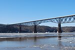
Considered an engineering marvel of the day, the bridge has seven main spans. The total length is 6,768 feet (2,063 m), including approaches, and the top of the deck is 212 feet (65 m) above water. It is a multispan cantilever truss bridge, having two river-crossing cantilever spans of 548 feet (167 m) each, one center span of 546 feet (166 m), two anchor (connecting) spans of 525 feet (160 m), two shore spans of 201 feet (61 m) each, a 2,641 feet (805 m) approach viaduct on the eastern bank and a 1,033 feet (315 m) approach viaduct on the western bank. All seven spans were built of newly available Bessemer process "mild" (between 0.16% and 0.29% carbon) steel, while the two approach viaducts were built of iron. It formed part of the most direct rail route between the industrial northeastern states and the midwestern and western states.[16]
Operation
Poughkeepsie Bridge ca. 1900Under the Bridge, early 20th century
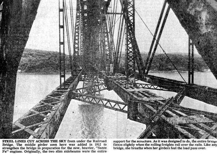
A strengthening of the bridge was completed in 1907[18] to handle heavier freight trains by engineerRalph Modjeski, of the famed bridge civil engineering firm Modjeski and Masters, who added a third line of trusses down the middle, a central girder, and interleaved columns.[19][20] In 1917ŌĆō18, the double tracks on the bridge were converted to gauntlet track operation to center the weight of heavier New Haven Railroad 2-10-2 steam locomotives. Even so, trains were restricted to 12 miles per hour.[21] In 1959, the gauntlet tracks were replaced by a centered single track.[17]
During World War II, the bridge was a vital link for war freight traffic, guarded around the clock by United States Army soldiers. At its peak, nearly 3,500 train cars crossed over the Hudson on a daily basis.[14][17]
Decline
From Highland's Johnson-Iorio Park
Traffic across the bridge began a slow decline in the 1950s as industry shrank in New England and with it the need for the raw materials railroads excelled at transporting. Traffic from the connecting New York, Ontario & Western ceased when that railroad shut down on March 30, 1957. Another connection, the coal-, slate-, and cement-hauling Lehigh & New England, shut down in 1961. At the same time, some new traffic began crossing the bridge, such as the New Haven's "Super Jet", one of the first trains to carry truck trailers. The Penn Central's acquisition of the New Haven in 1969 discouraged connecting traffic with the Erie Lackawanna, which competed with other Penn Central routes. After 1971, only one through train in each direction, for Erie Lackawanna, crossed the bridge.[22]
On May 8, 1974, a tie fire damaged about 700 feet (210 m) of decking and underlying girders on the bridge's eastern section.[23] It was likely started by a spark from an eastbound Penn Central freight train that had just crossed the span.[24] The Penn Central had neglected the bridge's fire-protection system, which had no water on the day of the fire, and had laid off employees who kept watch for such fires.[13] A photograph of the last train, a run-through from the Erie Lackawanna, was included in a 40th anniversary web feature by the Poughkeepsie Journal.[25]
In August 1974, the Penn Central applied for $1.75 million to repair and improve the bridge from the federal government through the Regional Rail Reorganization Act of 1973.[26] By 1975, efforts had shifted to acquiring a combination of state and railroad funding. In November 1975, a formal agreement between the New York State Department of Transportation and the trustees of the Penn Central was approved, allowing the $359,000 insurance payout for the bridge to be spent on repairs, with the state paying the rest. In December, U.S. Representative Benjamin A. Gilman announced that $486,000 appropriated by the state legislature for repairs was undergoing final review by the state.[27] Authorization for the state to spend its share on bridge repairs had still not been given when, on April 1, 1976, ownership of the bridge changed with the inception of Conrail.[28] Having been forced to include the route over the bridge (the Maybrook Line)
In 1981, seven years after the fire, which was hot enough to warp the gauntlet track, ending rail service.
in its new system at the behest of Connecticut Senator Abraham Ribicoff, Conrail announced that it would not promise to repair and use the bridge despite a Connecticut foundation's offer to pay half the repair cost if the bridge were used again. The railroad further said that other work required to make the entire Maybrook route usable would raise the reactivation cost to $45.8 million.[29][30]
Seven years passed; pieces of the bridge's eastern approach viaduct over Poughkeepsie began falling onto U.S. Route 9 below, damaging passing vehicles. In response, the city sued Conrail and forced it to spend $300,000 in 1983 to remove the decking over the superstructure. Conrail then sought to dispose of the unused bridge and eventually abandoned and tore up the Maybrook Line between Hopewell Junction and Maybrook, New York, in 1983ŌĆō1984.[30]
Railway Management Associates (1984–1998)
Conrail made initial plans to sell the bridge to bridge enthusiast and lawyer Donald L. Pevsner, by an option granted to him on February 1, 1984.[31][32] Conrail and Central Hudson Gas and Electric were involved with negotiations regarding Central Hudson's two electrical circuits traversing the bridge. The New York State Supreme Court endorsed an agreement in September 1984 whereby Conrail would make every attempt to obtain the permits by May 1985 to demolish the bridge, and Central Hudson would make every attempt to find an alternative route for its circuits by May 1985. Conrail knew that there was lead paint on the bridge, permits for demolition might be difficult to obtain, and demolition costs would be high.[33] Later in 1984, Conrail advised Pevsner to take title of the bridge in a shell corporation, with no assets but the bridge and no funds to pay for necessary insurance and maintenance: the railroad just wanted to be rid of the bridge, whatever the ethics of such disposal. This decision was made personally by then-Conrail Chairman L. Stanley Crane, at a time when Conrail was owned by the U.S. government. Pevsner refused, and let his option expire on November 1, 1984.[13] One day later, on November 2, 1984, Conrail sold the bridge for $1 to a group of investors from St. Davids, Pennsylvania, called Railway Management Associates to "get it off the books". The only known member of this investor group was a convicted bank swindler and ex-felon named Gordon Schreiber Miller.[34][35][36] For less than a year, Miller collected $10,000 in monthly rent paid by Central Hudson Gas & Electric Corporation for its two 115,000-volt and 69,000-volt circuits representing six power cables across the Hudson, attached to the south side of the bridge since 1949.[37] Central Hudson de-energized those power lines and relocated them under the river by early 1985, thereby ending Miller's only source of bridge income.[30][33][35] For the next fourteen years, Miller and his successor, Vito Moreno, spent little to nothing on maintenance or insurance; critical bridge navigation lights were mostly inoperative, resulting in large U.S. Coast Guard fines against the Miller corporation that all went unpaid. Further, all of the 2,200-pound brackets that connected Central Hudson's de-energized high-tension power lines to the south side of the bridge continued to deteriorate by rusting. Though Central Hudson admitted that it normally had a legal duty to remove its abandoned power lines, it refused to remove its abandoned bridge-affixed lines, instead relying on a claim that it no longer owned the lines at issue pursuant to prior litigation with Conrail that was decided on September 26, 1984,[38] and won a similar legal opinion before the New York State Public Service Commission in 1995, which was left to stand on April 1, 1999, when The Poughkeepsie-Highland Railroad Bridge Company, Inc., as the successor owner to Gordon Schreiber Miller and Vito Moreno, withdrew its 1998 complaint against Central Hudson on January 27, 1999.[39]
Restoration
Detail of concrete decking and original steel structureOpening Day crowds, October 3, 2009The elevator as seen from Upper Landing Park
On June 4, 1998, following the long nonpayment of Dutchess and Ulster County taxes on the bridge by prior owners Gordon Schreiber Miller and his successor, Vito Moreno, Moreno deeded the bridge to a nonprofit volunteer organization called Walkway Over the Hudson, which took title through its nonprofit New York corporation, the Poughkeepsie-Highland Railroad Bridge Company, Inc., hoping to turn it into a pedestrian and cyclist walkway. The deed was recorded in both counties on June 5, 1998. The former Central Hudson power lines were finally removed in 2009, as part of Walkway construction. On December 21, 2010, the Walkway corporation conveyed the entire structure to the New York State Bridge Authority, which restored high-limit liability insurance and "deep-pocket" maintenance assurance for the first time since November 2, 1984.[40] On September 5, 2009, conversion work and repairs to the structural steel and the laying of concrete slabs for the walkway were completed. The volunteer head of "Walkway", as it is known locally, said in 2008, "We think people will come from all over. It's the equivalent of the Eiffel Tower, or the Golden Gate Bridge."[41] The project initially received support from local residents, city and state officials totaling about $1,000,000, plus forgiveness of $550,000 in taxes inherited from the previous owners.[42][43] Walkway then solicited funding from both the State and Federal governments for historic preservation, and from private philanthropic organizations.[44] Funding sources as of January 13, 2016, include:[45]
The Dyson Foundation, which has donated almost $20 million, including guaranteeing $8.1 million in loans that were made by Ulster Savings Bank and M&T Bank to complete the project in 2009 (now paid-off), plus $2.3 million to build the elevator that was completed in 2014.
New York State funding, from various entities, totals about $22.5 million.
Federal government funding, from various entities, totals about $3.5 million.
Scenic Hudson, Inc., which has donated $1 million.
The Jane W. Nuhn Charitable Trust has donated $500,000.
The M&T Charitable Foundation has donated between $50,000 and $100,000.
Amy P. Goldman and Sarah Arno have donated between $100,000 and $250,000.
The total budget as of October 2009 totaled about $38.8 million. The Walkway Group raised a total of $30.7 million as of October 23, 2009. The $8.1 million deficit was financed by lines of credit from Ulster Savings Bank ($4 million) and M&T Bank ($4.1 million) that were drawn-upon to complete the project in 2009.[46] These lines of credit were converted to loans, with an additional $2.3 million allocated to 2014 elevator construction, and were guaranteed and paid-off by The Dyson Foundation (see above).[47]
The project was separated into four phases, with the first two completed as of October 2009:[48]
Phase 1 ŌĆō attain ownership of the bridge.
Phase 2 ŌĆō structural analysis of the bridge and creation of a comprehensive plan, including budget and timeline for completion. The group also had to find funding for the project and secure funding for the start of construction.
Phase 3 ŌĆō construct and open the first 1,800 feet (550 m) of the walkway on the Ulster side. The Dutchess side will get an elevator and 900 feet (270 m) of walkway. This phase was complete on October 3, 2009 (the grand-opening date), excepting a $2.3 million elevator installation in Poughkeepsie that was completed during the summer of 2014.
Phase 4 ŌĆō construct and open the remaining 4,068 feet (1,240 m) of the walkway and its resultant connections to the Hudson Valley Rail Trail in Highland and the Dutchess Rail Trail in Poughkeepsie. The walkway was completed on September 5, 2009, and opened to the public on October 3, 2009. The Hudson Valley Rail Trail connection was finished in the autumn of 2010. The Dutchess Rail Trail connection has also been completed.
The piers were inspected in 2008 and given a clean bill of health.[49] Similarly, Bergmann Associates, P.C. (of Rochester and Albany, New York), project engineers and managers, has stated in writing that the wind loads were carefully examined for the replacement, solid-concrete Walkway decking, and that this item is not a safety problem.[50] The decking work was completed on September 5, 2009. Walkway opened the bridge to the public on October 3, 2009, in time for the quadricentennial celebration of Henry Hudson sailing up the Hudson River, and that day handed it over to the New York State Office of Parks, Recreation and Historic Preservation for management. Despite this, inevitable comparisons have been drawn to the similar Kinzua Bridge, in northwestern Pennsylvania, which blew over in a microburst tornado when the bolts connecting the steel framework to the piers failed. Ironically, renovation work was going on to strengthen the corroded areas when the tornado destroyed most of this former Erie Railroad viaduct. During Hurricane Irene, residents living within 500 feet of the Poughkeepsie Bridge were evacuated as a precaution, and emergency repairs to reduce bridge sway (by the addition of new steel X-braces, supplanting the original turnbuckle-adjusted tension rods) were hurriedly installed.[citation needed]
The opening ceremony of the Walkway Over the Hudson State Historic Park was held on October 3, 2009, as part of wider NY400 celebrations, featured music by Pete Seeger, and was attended by Governor David Paterson, Senator Chuck Schumer, Congressman Maurice Hinchey, president of nearby Vassar CollegeCatharine Bond Hill,[52] John May, engineer of the last train across the bridge, and other officials. Paterson said, "This bridge is now the longest footbridge in the world."[8]
The walkway immediately saw many more visitors than the expected 267,000 per year. In its first three months, it saw about 415,000 people.[53]
The walkway is operated as part of the New York State Historic Park System, open from 7:00 a.m. to dusk. Limited, wheelchair-friendly parking is available on either end of the bridge:
East end: 61 Parker Avenue, city of Poughkeepsie; charges $5 fee to park[54]
There are restrooms located at the ends of the walkway, although at the time of a 2008 engineering survey of the bridge, there was "not a johnny on the spot."[55] Pets are permitted, but owners should bring equipment to clean up. Bicycles and roller blades (but not skateboards) are permitted, and the walkway is flat and relatively wheelchair-friendly.[54]
On May 22, 2013, the Walkway Over the Hudson organization opened a new east pavilion, built entirely through donations of money and services. The pavilion will be occupied by the volunteers who serve as walkway ambassadors who greet and offer assistance to visitors.[56]
In October 2013, a "mobile web tour" was introduced, consisting of QR codes at locations on the walkway which link to Web content related to the spot.[57]
In summer 2014, an elevator connecting Upper Landing Park to the walkway was opened. This allows visitors to reach the center of the span via a more direct route. It also connects the walkway to the Poughkeepsie waterfront area, which is near the railroad station, Mid-Hudson Children's Museum, and Waryas Park.
On June 29, 2018, the $5.4 million, 3,500-square-foot Ulster Welcome Center at the western gateway officially opened. The facility has a plaza and amphitheater, 1,400 square foot covered patio and concession stand and public restrooms.[58] On June 20, 2019, the $3 million Dutchess Welcome Center at the eastern end of the park was dedicated and opened to the public. The 1,800 square-foot facility features restrooms, bike racks, tourist information, an outdoor patio with benches and a water fountain for dogs. Dual entrances are off Washington Street and Orchard Place.[59] A new glassed-in elevator, opened on June 20, 2019, that takes visitors to the Walkway from Upper Landing Park has been rebuilt with new "energy chain" technology which will make operations more reliable.[citation needed]
On October 25, 2021, Governor Kathy Hochul dedicated the new East Gate Plaza for the Walkway Over The Hudson. The location, outside the Poughkeepsie entrance, doubled the gathering space on top of the Washington Street stairs. The space is suitable for community and other events. The project cost $2 million and was funded through State Parks Capital Funds, the Environmental Protection Fund and support from the Friends of the Walkway.[60]
Events and incidents
The first footrace on the walkway occurred the day after the official opening on October 4, 2009. The 5k race started on the Highland side, crossed to the Poughkeepsie side and turned around at the parking lot and finished back in Highland. The race was won by James Boeding in a time of 16:26. The female winner was Kira DiCaprio in 20:12. There were 660 recorded finishers of the race.[61] The 5K race, called "Treetops to Rooftops," has become an annual event, organized by the Mid-Hudson Road Runners Club.[62] The inaugural Walkway Marathon was held on June 13, 2015, with full and half marathons and a 5K run. A new addition in 2016 was the Think Differently Dash, a one-mile race for people with physical and developmental disabilities.
On May 15, 2010, LEDs were turned on for the first time, designed to allow nighttime use of the bridge, though due to funding limitations this is expected to only be used on special occasions. Some 3,000 people paid $5 apiece to attend the sold-out ceremony.[63] Crowd management presented a problem, prompting criticism and an apology from walkway organizational leaders, but ultimately no incident or injury.[64]
Though typically closed at sunset each day, the walkway often has events after sundown. Some of these openings (such as for Independence Day and in December) include fireworks displays.[65] In July 2012, in a photograph taken from the walkway, an amateur photographer captured what the New York Daily News described as a "breathtaking juxtaposition" capturing fireworks and a bolt of lightning in the same image.[66] Some of the nighttime events have featured members of the Mid-Hudson Astronomical Association, who have provided telescopes for public viewing of the moon, stars, and planets from the walkway,[67] along with lectures by local astronomer Bob Berman.[68]
On January 21, 2017, a march was held there as part of the worldwide 2017 Women's March the day after the inauguration of Donald Trump as president, drawing an estimated 5,000 participants, extending the entire length of the walkway.[69]
^ abcMabee, Carleton (2001). Bridging The Hudson: The Poughkeepsie-Highland Railroad Bridge and Its Connecting Railroad Lines. Purple Mountain Press. ISBN1-930098-24-3.
^ ab"History". Walkway Over the Hudson. Archived from the original on April 1, 2017. Retrieved December 8, 2016.
^ abWolf, Donald E. (2010). Crossing the Hudson; Historic Bridges and Tunnels of the River. Rivergate Books. ISBN9780813547084.
^Poughkeepsie Eagle. Souvenir Edition, January 1, 1889; plus independent engineering articles from the period.
^ abcDrury, George H. (1994). The Historical Guide to North American Railroads: Histories, Figures, and Features of more than 160 Railroads Abandoned or Merged since 1930. Waukesha, Wisconsin: Kalmbach Publishing. pp. 222ŌĆō229, 248. ISBN0-89024-072-8.
^Earlier demolition bids received by Conrail in 1983 were reported in Carleton Mabee's book, "Bridging The Hudson: The Poughkeepsie Railroad Bridge and Its Connecting Rail Lines", also cited in Footnote 3.
^For the entire saga of Donald Pevsner's involvement with Conrail, which saved the bridge from Conrail demolition in 1984, see his Oral History Project [1] by the Hudson Valley Institute at Marist College, updated to March 17, 2004.
^Documentation of the annual rent amount paid by Central Hudson to Conrail prior to the Miller bridge purchase is located in New York State Public Service Commission records; in Court documents for the case of Consolidated Rail Corporation v. Central Hudson Gas & Electric Corporation (cited in Footnote 9); and in Poughkeepsie Journal news stories in 1984-5.
^Consolidated Rail Corporation v. Central Hudson Gas & Electric Corporation, Supreme Court, County of Westchester, State of New York.
^Dispute between Central Hudson Gas & Electric Corporation and The Poughkeepsie-Highland Railroad Bridge Company, Inc., New York State Public Service Commission CASE 98-E-0439.
^Walkway organization press release, December 22, 2010.
^"Hudson rail bridge to be high-altitude walkway". Associated Press. October 26, 2008.
^Marano, Greg (August 10, 2008). "Design has helped to protect span, experts say". Pouhgkeepsie Journal. p. 2A – via Newspapers.com. 'We determined that the condition has not changed much at all since 1969'
^Email from Peter Melewski, Bergmann Associates, P.C. Project Manager (Albany office), to Donald L. Pevsner, dated December 4, 2009: in possession of the Walkway Group.
Mapa ├®tnico de Yemen Seg├║n World Population,[1] en Yemen hab├Ła, en 2019, 29.388.000 hab., con una densidad de 53,5 hab/km┬▓. La poblaci├│n urbana era del 35,2%, con un m├Īximo en la capital, San├Ī, de 3,937.000 hab. Ciudades como Taiz, Al Hudayda y Aden tienen en torno a 500.000 hab. La mayor parte de los yemen├Łes es de origen ├Īrabe; no obstante, es una sociedad fuertemente tribal, con cerca de 400 tribus zaidinas o zaid├Łes en el norte y grupos de castas hereditarias en las zonas ur…
Museo Nazionale del Brasile(PT) Museu Nacional Il Palazzo di San Cristoforo (Pa├¦o de S├Żo Crist├│v├Żo), sede del Museo Nazionale, in una fotografia del 2011 UbicazioneStato Brasile Localit├ĀRio de Janeiro IndirizzoParco di Boa Vista (Quinta da Boa Vista), S├Żo Crist├│v├Żo[1] Coordinate22┬░54ŌĆ▓21ŌĆ│S 43┬░13ŌĆ▓34ŌĆ│W / 22.905833┬░S 43.226111┬░W-22.905833; -43.226111Coordinate: 22┬░54ŌĆ▓21ŌĆ│S 43┬░13ŌĆ▓34ŌĆ│W / 22.905833┬░S 43.226111┬░W-22.905833; -43.…
Ini adalah nama Korea; marganya adalah Kim. Artikel ini bukan mengenai Bona (penyanyi). KeiKei di bulan Mei 2018Nama asalĻ╣Ćņ¦ĆņŚ░LahirKim Ji-yeon20 Maret 1995 (umur 28)Incheon, Korea SelatanPendidikanSekolah Menengah Atas Incheon YoungsunPekerjaanPenyanyiaktrisKarier musikGenreK-popTahun aktif2014ŌĆōsekarangLabelWoollim EntertainmentArtis terkaitLovelyz Nama KoreaHangulĻ╣Ćņ¦ĆņŚ░ HanjaķćæÕ┐ŚÕ¦Ė Alih AksaraGim Ji-yeonMcCuneŌĆōReischauerKim Chi-y┼Ån Kim Ji-yeon (Hangul: Ļ╣Ćņ¦ĆņŚ…
I3 i3 dengan Vim dan TerminalTipemanajer jendela menyusun dan perangkat lunak bebas Versi pertama16 Maret 2009; 14 tahun lalu (2009-03-16)[1]Versi stabil 4.23 (29 Oktober 2023) LisensiLisensi BSD[2]Karakteristik teknisSistem operasiGNU/Linux, BSD (en), macOS dan mirip Unix Ukuran1.3 MiB[3]Bahasa pemrogramanC Informasi pengembangPembuatMichael StapelbergSumber kode Kode sumberPranala Debiani3-wm Arch Linuxi3-wm Ubuntui3-wm Gentoox11-wm/i3 Fedorai3 Informasi tambahanSi…
Ashurnasirpal IIAssyrianAshurnasirpal II, dengan prasasti AkkadiaBerkuasa883 - 859 BCPendahuluTukulti-Ninurta IIPenerusShalmaneser IIIAyahTukulti-Ninurta II Ashur-nasir-pal II (tengah) bertemu dengan seorang pejabat tinggi setelah pertempurannya sukses. Ashur-nasir-pal II (transliteration: A┼Ī┼Īur-n─üß╣Żir-apli, berarti Ashur adalah wali dari ahli waris[1]) adalah raja Assyria yang memimpin dari 883 sampai 859 BC. Ashurnasirpal II menggantikan ayahnya, Tukulti-Ninurta II, 883 SM. Selama …
Susu Amaltheia diminum oleh Zeus Dalam mitologi Yunani, Amalteia atau Amalthea (Yunani Kuno: ß╝ł╬╝╬¼╬╗╬Ė╬Ą╬╣╬▒) merupakan nama dari seekor kambing betina yang dipakai untuk memberikan Zeus susu.[1][2] Etimologi Nama Amalthea, dalam bahasa Yunani berarti dewi lembut, julukan yang menandakan kehadiran dewi pengasuh[3] atau dewi-gadis[4] yang oleh orang Hellenes diketahui berlokasi di Kreta, di mana orang Minoa menyebutnya versi Dikte.[5] Dalam mitologi Infan…
Duta Besar Amerika Serikat untuk Antigua dan BarbudaSegel Kementerian Dalam Negeri Amerika SerikatPetahanaLinda Swartz Taglialatelasejak 1 Februari 2016Dicalonkan olehPresiden Amerika SerikatDitunjuk olehPresidendengan nasehat SenatPejabat perdanaPaul Byrnessebagai Charg├® d'AffairesDibentuk1 November 1981Situs webU.S. Embassy - Bridgetown Duta Besar Amerika Serikat untuk Antigua dan Barbuda adalah perwakilan resmi pemerintahan Amerika Serikat untuk pemerintahan Antigua dan Barbuda. Nama ja…
Cipoh agung Ilustrasi Status konservasi Risiko Rendah (IUCN 3.1)[1] Klasifikasi ilmiah Domain: Eukaryota Kerajaan: Animalia Filum: Chordata Kelas: Aves Ordo: Passeriformes Superfamili: Malaconotoidea Famili: Aegithinidae Genus: Aegithina Spesies: Aegithina lafresnayeiHartlaub, 1844 Cipoh agung (Aegithina lafresnayei ) adalah spesies burung dalam keluarga Aegithinidae. Ia dijumpai di Kamboja, China, Laos, Malaysia, Myanmar, Thailand, dan Vietnam. Habitat aslinya adalah Hutan tropis d…
Jaya ArjaBiografiKematianBelandean Tempat pemakamanMakam Mantri Jaya Arja Data pribadiAgamaIslam KegiatanPekerjaanPanglima perang Jaya Arja adalah seorang panglima terkenal yang berjuang melawan penjajah Belanda pada masa Perang Banjar Barito di pedalaman Indonesia. Meskipun mungkin belum dikenal secara luas di beberapa daerah, namanya menjadi legenda di kawasan Belandean, terutama di Kecamatan Alalak, Kabupaten Barito Kuala.[1] Kehidupan Awal Makam Jaya Arja di Belandean Muara, Alalak, …
Artikel ini bukan mengenai Cosette.Artikel atau bagian artikel ini diterjemahkan secara buruk. Kualitas terjemahannya masih kurang bagus. Bagian-bagian yang mungkin diterjemahkan dari bahasa lain masih perlu diperhalus dan disempurnakan. Anda dapat mempertimbangkan untuk menelusuri referensinya dan menulis ulang artikel atau bagian artikel ini. Anda juga dapat ikut bergotong royong pada ProyekWiki Perbaikan Terjemahan. (Pesan ini dapat dihapus jika terjemahan dirasa sudah cukup tepat. Lihat pula…
Artikel ini perlu dikembangkan agar dapat memenuhi kriteria sebagai entri Wikipedia.Bantulah untuk mengembangkan artikel ini. Jika tidak dikembangkan, artikel ini akan dihapus.Artikel ini tidak memiliki referensi atau sumber tepercaya sehingga isinya tidak bisa dipastikan. Tolong bantu perbaiki artikel ini dengan menambahkan referensi yang layak. Tulisan tanpa sumber dapat dipertanyakan dan dihapus sewaktu-waktu.Cari sumber: Bashkiria 1917ŌĆō1919 ŌĆō berita ┬Ę surat kaba…
United States historic placeKort GroceryU.S. National Register of Historic Places Kort GroceryShow map of KentuckyShow map of the United StatesLocationFour Mile Pike, Camp Springs, KentuckyCoordinates39┬░0ŌĆ▓1ŌĆ│N 84┬░21ŌĆ▓49ŌĆ│W / 39.00028┬░N 84.36361┬░W / 39.00028; -84.36361Built1880Built byPeter KortMPSGerman Settlement, Four Mile Creek Area TRNRHP reference No.83002606[1]Added to NRHPMarch 9, 1983 Kort Grocery, also known as Camp Springs Grocery, is …
Resolusi 6Dewan Keamanan PBBBendera Perserikatan Bangsa-BangsaTanggal17 Mei 1946Sidang no.42KodeS/RES/6 (Dokumen)TopikPendaftaran keanggotaanRingkasan hasil11 mendukungTidak ada menentangTidak ada abstainHasilDiadopsiKomposisi Dewan KeamananAnggota tetap Tiongkok (ROC) Prancis Britania Raya Amerika Serikat Uni SovietAnggota tidak tetap Australia Brasil Mesir Meksiko Belanda Polandia Resolusi 6 Dewan Keamanan Perserikatan Bangsa-Ban…
Singapore Telecommunications LimitedKantor pusat Singtel Di SingapuraJenisPublikIndustriTelekomunikasiDidirikanSingapura (1879)KantorpusatSingapuraTokohkunciSimon Israel, (Ketua) Chua Sock Koong, (CEO) Jeann Low, CFOProdukJasa telepon genggam Internet Jasa jaringan permanenPendapatan$15.34 juta SGD (2022)Karyawan>25,000Situs webSingtel Singapore Telecommunications Limited (SGX: T48) (disingkat Singtel) adalah perusahaan telekomunikasi terbesar di Singapura. Bila pelanggan dari anak perusahaan…
Shelley Winters (terlahir Shirley Schrift; 18 Agustus 1920 ŌĆō 14 Januari 2006) adalah seorang aktris Amerika Serikat. Winters adalah anak perempuan dari pasangan kaum Yahudi ŌĆö Jonas Schrift (seorang immigran) dan Rose Winter (lahir di AS) ŌĆö yang bermukim di Negara Bagian Illinois. Shelley Winters sekitar tahun 1940-an Ia belajar di Hollywood Studio Club dan berkongsi kamar dengan Marilyn Monroe. Winters kabarnya pernah berselingkuh dengan Joseph P. Kennedy, Sr., ayah mantan Presiden John F.…


.jpg)
_-_cropped.jpg)


")


")


